
Hudson Strait links the Atlantic Ocean and Labrador Sea to Hudson Bay in Canada. This strait lies between Baffin Island and Nunavik, with its eastern entrance marked by Cape Chidley in Quebec and Resolution Island off Baffin Island. The strait is about 750 km long with an average width of 125 km, varying from 70 km at the eastern entrance to 240 km at Deception Bay.

The Arctic Archipelago, also known as the Canadian Arctic Archipelago, is a group of islands north of the Canadian mainland.
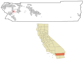
Romoland is a census-designated place (CDP) in Riverside County, California, United States. The population was 1,684 at the 2010 census, down from 2,764 at the 2000 census.

Crestline is a census-designated place in the San Bernardino Mountains of San Bernardino County, California, USA. The population was 10,770 at the 2010 census, up from 10,218 at the 2000 census.

Orr is a city in Saint Louis County, Minnesota, United States. The population was 267 at the 2010 census.

The Cape York meteorite is named for Cape York, near the location of its discovery in Savissivik, Meteorite Island, Greenland, and is one of the largest iron meteorites in the world.

Cloo was an American digital cable television channel with programming originally dedicated to the crime and mystery genres, though it often fell out of this format in its later years with a more generic selection of series and films, and was used as an example of channel drift and superfluous channel bundling, presenting series easily found through other venues. The network was owned and operated by NBCUniversal.

Irwin Glacier is a steep tributary glacier in the Bowers Mountains of Antarctica, draining northeast from Edlin Névé and at the terminus coalescing with Montigny Glacier, with which it enters the larger Graveson Glacier. The glacier was mapped by the United States Geological Survey from surveys and U.S. Navy air photos, 1960–64, and was named by the Advisory Committee on Antarctic Names for Carlisle S. Irwin, a former glaciologist who participated in the study of Meserve Glacier in 1966–67. The glacier lies situated on the Pennell Coast, a portion of Antarctica lying between Cape Williams and Cape Adare.

The Danco Coast is that portion of the west coast of the Antarctic Peninsula between Cape Sterneck and Cape Renard. This coast was explored in January and February 1898 by the Belgian Antarctic Expedition under Adrien de Gerlache, who named it for Lieutenant Emile Danco who died on the expedition.
Beascochea Bay is a bay, 10 nautical miles (19 km) long and 5 nautical miles (9 km) wide, indenting the Graham Coast of Graham Land, Antarctica, between Kiev Peninsula and Barison Peninsula, and entered south of Cape Perez. The glaciers Lever, Funk, Cadman, Talev and Butamya feed the bay.

Graham Coast is the portion of the west coast of Graham Land in Antarctic Peninsula, extending 172 km between Cape Bellue to the southwest and Cape Renard to the northeast.

Mount Cloos is a dome-shaped mountain probably over 915 metres (3,000 ft) high, standing at the north side of Girard Bay and 2.3 miles (3.7 km) northeast of Cape Cloos, on the northwest coast of Kiev Peninsula in Graham Land. It was discovered by the Belgian Antarctic Expedition of 1897–99 under Gerlache. It was named in association with Cape Cloos by the French Antarctic Expedition of 1908–10 under Jean-Baptiste Charcot.
Obelisk Col is a col at about 150 m on the east side of Cape Obelisk, James Ross Island, aligned north-south between Rum Cove and Rohss Bay. Named after Cape Obelisk by the United Kingdom Antarctic Place-Names Committee (UK-APC) in 1983.
Vogel Glacier is a glacier flowing into Flandres Bay 3 nautical miles (6 km) southeast of Cape Willems, on the west coast of Graham Land. The glacier appears on an Argentine government chart of 1952. Named by the United Kingdom Antarctic Place-Names Committee (UK-APC) in 1960 for Hermann W. Vogel (1834–1898), German chemist who introduced the first orthochromatic emulsion for photographic plates in 1903.
Deliverance Point is a rocky point 2.5 nautical miles (5 km) south of Cape Tuxen on the west coast of Graham Land. It was discovered by the French Antarctic Expedition, 1908–10, under Jean-Baptiste Charcot, and was so named because Charcot and two companions were rescued here after being separated from the ship Pourquoi-Pas? for several days, while on an exploration of the area in a small boat.
Hotine Glacier is a glacier 10 nautical miles (19 km) long which is divided at its mouth by Mount Cloos, flowing west into both Deloncle Bay and Girard Bay on Kiev Peninsula, on the west coast of Graham Land, Antarctica. It was first charted by the Belgian Antarctic Expedition under Gerlache, 1897–99, and was named by the UK Antarctic Place-Names Committee in 1959 for Brigadier Martin Hotine, Director of Overseas Surveys.
Mount Rio Branco is a mountain, 975 m, standing 2.5 nautical miles (4.6 km) east of Cape Perez on the west coast of Graham Land. Discovered by the French Antarctic Expedition, 1908–10, and named by Charcot for Baron Rio Branco, at that time Minister of Foreign Affairs of Brazil.


