Related Research Articles

Thurston Island is a largely ice-covered, glacially dissected island, 135 nautical miles long and 55 nautical miles wide, lying between between Amundsen Sea and Bellingshausen Sea a short way off the northwest end of Ellsworth Land, Antarctica. The island is separated from the mainland by Peacock Sound, which is occupied by the west portion of Abbot Ice Shelf.
The Bay of Winds is a coastal embayment between Cape Dovers and Avalanche Rocks in Antarctica. It was discovered by the Western Base Party of the Australasian Antarctic Expedition, 1911–14, under Mawson, who so named it because of the almost constant outflow of cold dense air from the plateau into the bay.
Cape Folger is an ice-covered cape forming the east side of the entrance to Vincennes Bay on the Budd Coast of Antarctica. The position of Cape Folger correlates closely with the west end of Charles Wilkes' "Budd's High Land", as charted as a coastal landfall by the United States Exploring Expedition in 1840. The cape was mapped from aerial photographs taken by U.S. Navy Operation Highjump, 1946–47, and was named by the Advisory Committee on Antarctic Names for Commander Edward C. Folger, Jr., U.S. Navy, commander of the icebreaker Edisto which assisted Operation Windmill parties in establishing astronomical control stations in the Windmill Islands, close southwest in Vincennes Bay.
King Peninsula is an ice-covered peninsula, 100 nautical miles long and 20 nautical miles wide, lying south of Thurston Island and forming the south side of Peacock Sound, Antarctica. It projects from the continental ice sheet and trends west between the Abbot Ice Shelf and Cosgrove Ice Shelf to terminate at the Amundsen Sea.
Athos Range is the northernmost range in the Prince Charles Mountains of Mac. Robertson Land, Antarctica. The range consists of many individual mountains and nunataks that trend east–west for 40 miles (64 km) along the north side of Scylla Glacier.
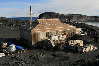
Cape Royds is a dark rock cape forming the western extremity of Ross Island, facing on McMurdo Sound, Antarctica. It was discovered by the British National Antarctic Expedition (BrNAE) (1901–1904) and named for Lieutenant Charles Royds, Royal Navy, who acted as meteorologist on the expedition. Royds subsequently rose to become an Admiral and was later Commissioner of the Metropolitan Police, London. The cape is the site of Shackleton's Hut, the expedition camp of the British Antarctic Expedition, 1907–09.

Posadowsky Glacier is a glacier about 9 nautical miles long, flowing north to Posadowsky Bay immediately east of Gaussberg. Posadowsky Bay is an open embayment, located just east of the West Ice Shelf and fronting on the Davis Sea in Kaiser Wilhelm II Land. Kaiser Wilhelm II Land is the part of East Antarctica lying between Cape Penck, at 87°43'E, and Cape Filchner, at 91°54'E, and is claimed by Australia as part of the Australian Antarctic Territory. Other notable geographic features in this area include Drygalski Island, located 45 mi NNE of Cape Filchner in the Davis Sea, and Mirny Station, a Russian scientific research station.
Conradi Peak is an isolated peak, 1,040 metres (3,410 ft) high, rising northward of the Napier Mountains and inland from the coast, some 19 nautical miles (35 km) southwest of Cape Borley. It was discovered in January 1930 by the British Australian New Zealand Antarctic Research Expedition (BANZARE) under Mawson, who named it after a prominent member of the South African government who, in 1929, rendered much help to BANZARE during the stay of the Discovery at Cape Town.
Chapman Snowfield is a large snowfield lying west of the central ridge in the Churchill Mountains in the Ross Dependency region of Antarctica.
Cape Close is a cape on the coast of Enderby Land, 30 nautical miles (60 km) west of Cape Batterbee. It was discovered by the British Australian New Zealand Antarctic Research Expedition, 1929–31, under Mawson, who named it for Sir Charles Close, President of the Royal Geographical Society, 1927–30.

Cape Jules is a rocky cape with a small cove along its northern end, 3 nautical miles (6 km) west of Zelee Glacier Tongue, Antarctica. It was discovered and named by the French expedition under Dumont d'Urville, 1837–40. Jules is the given name of the discoverer, Captain Jules Dumont d'Urville, as well as his son. The area was charted by the Australasian Antarctic Expedition in 1912–13, and again by the British Australian and New Zealand Antarctic Research Expedition in 1931, both under Mawson. The French Antarctic Expedition under Michel Barre established astronomical control at this locality in 1951.
Cape Kolosov is a point along the west side of the ice-covered peninsula that forms the east side of the entrance to Amundsen Bay, Antarctica. It was photographed in 1956 from Australian National Antarctic Research Expeditions aircraft, and rephotographed in 1958 by a Soviet expedition. The cape was named after the polar aviation navigator V. Kolosov, who died in the Arctic.

Field Glacier is a glacier on Pernik Peninsula, Loubet Coast in Graham Land, situated south of Salmon Cove, and flowing west into Lallemand Fjord just south of Kanchov Peak. It was mapped from air photos taken by the Falkland Islands and Dependencies Aerial Survey Expedition, 1956–57. In association with the names of glaciologists grouped in this area, it was named by the UK Antarctic Place-Names Committee after William B.O. Field, an American glaciologist and surveyor, sometime Research Fellow of the American Geographical Society.
Fitchie Bay is a bay lying between Cape Dundas and Cape Whitson on the south side of Laurie Island, in the South Orkney Islands. It was charted in 1903 by the Scottish National Antarctic Expedition under William Speirs Bruce, who named it for John Fitchie, second mate of the expedition ship Scotia.
Forel Glacier is a glacier 1.5 nautical miles (3 km) wide and 4 nautical miles (7 km) long, flowing southwest into Blind Bay, on the west coast of Graham Land, Antarctica. It was first roughly surveyed in 1936 by the British Graham Land Expedition under John Rymill. Its lower reaches were surveyed in 1949 by the Falkland Islands Dependencies Survey, and the glacier named by them for François-Alphonse Forel, a noted Swiss glacier physicist and author, and first President of the International Commission of Glaciers in 1894.
Cape Moyes is an ice-covered headland fronting on the Shackleton Ice Shelf, 18 nautical miles (33 km) west of Cape Dovers. It was discovered by the Australasian Antarctic Expedition (AAE) under Mawson, 1911–1914, and named by him for Morton H. Moyes, meteorologist with the AAE Western Base party.

Cape Meteor is a cape marked by steep cliffs in the coastal area of Mowinckelkysten, north of Svartstranda beach, and forms the eastern extremity of Bouvetøya island in the South Atlantic.
Cape Lollo, located at 54°25′S3°29′E, is a cape which forms the northeastern extremity of Bouvetøya in Norway. It was first charted in 1898 by a German expedition under Carl Chun, and was recharted and named in December 1927 by a Norwegian expedition under Captain Harald Horntvedt.
Cape Hunter is a rocky promontory on the west shore of Commonwealth Bay, Antarctica, 8 nautical miles (15 km) west of Cape Denison. It was discovered in 1912 and explored the following year by the Australasian Antarctic Expedition under Douglas Mawson, who named it for John G. Hunter, chief biologist of the expedition.
Cape Keltie is an ice-covered cape on the Clarie Coast of Antarctica, 11 nautical miles (20 km) west of Cape Cesney. It was discovered from the Aurora by the Australasian Antarctic Expedition (1911–14) under Douglas Mawson, and roughly charted at a distance of about 10 nautical miles (19 km) as lying in 66°5′S 133°0′E. It was named by Mawson for Sir John Scott Keltie, Secretary of the Royal Geographical Society, 1892–1915. The identification of this feature is based upon the G.D. Blodgett map of 1955, compiled from aerial photos taken by U.S. Navy Operation Highjump (1946–47).
References
- ↑ "Dovers, Cape". Geographic Names Information System . United States Geological Survey, United States Department of the Interior . Retrieved 2012-01-27.
![]() This article incorporates public domain material from "Dovers, Cape". Geographic Names Information System . United States Geological Survey.
This article incorporates public domain material from "Dovers, Cape". Geographic Names Information System . United States Geological Survey.
| | This Queen Mary Land location article is a stub. You can help Wikipedia by expanding it. |