
Sir Douglas Mawson OBE FRS FAA was an Australian geologist, Antarctic explorer, and academic. Along with Roald Amundsen, Robert Falcon Scott, and Sir Ernest Shackleton, he was a key expedition leader during the Heroic Age of Antarctic Exploration.
Drygalski Island is an ice-capped island that is 20.4 kilometres (11 nmi) long and rises to 325 m (1,066 ft) in the Davis Sea of the Southern Ocean, about 85 km (53 mi) north of the coast of Queen Mary Land and 45 km (28 mi) north-northeast of Cape Filchner. The island has an area of 220 km2 (85 sq mi).

The Queen Alexandra Range is a major mountain range of the Transantarctic Mountains System, located in the Ross Dependency region of Antarctica.

Xavier Guillaume Mertz was a Swiss polar explorer, mountaineer, and skier who took part in the Far Eastern Party, a 1912–1913 component of the Australasian Antarctic Expedition, which claimed his life. Mertz Glacier on the George V Coast in East Antarctica is named after him.

Denman Glacier is a glacier 11 to 16 km wide, descending north some 110 km (70 mi), which debouches into the Shackleton Ice Shelf east of David Island, Queen Mary Land. It was discovered in November 1912 by the Western Base party of the Australasian Antarctic Expedition under Sir Douglas Mawson. Mawson named the glacier for Lord Denman, Governor-General of Australia in 1911, a patron of the expedition.

The Australasian Antarctic Expedition was a 1911–1914 expedition headed by Douglas Mawson that explored the largely uncharted Antarctic coast due south of Australia. Mawson had been inspired to lead his own venture by his experiences on Ernest Shackleton's Nimrod expedition in 1907–1909. During its time in Antarctica, the expedition's sledging parties covered around 4,180 kilometres (2,600 mi) of unexplored territory, while its ship, SY Aurora, navigated 2,900 kilometres (1,800 mi) of unmapped coastline. Scientific activities included meteorological measurements, magnetic observations, an expansive oceanographic program, and the collection of many biological and geological samples, including the discovery of the first meteorite found in Antarctica. The expedition was the first to establish and maintain wireless contact between Antarctica and Australia. Another planned innovation – the use of an aircraft – was thwarted by an accident before the expedition sailed. The plane's fuselage was adapted to form a motorised sledge or "air-tractor", but it proved to be of very limited use.
Cape Hordern is an ice-free cape, overlain by morainic drift, at the northwest end of the Bunger Hills in Antarctica. It was probably sighted from Watson Bluff by A.L. Kennedy and other members of the Western Base Party of the Australasian Antarctic Expedition under Mawson, 1911–14, who charted the west wall of what appeared to be two small islands lying north of Cape Hoadley in about 100°35′E. It was named "Hordern Island" by Mawson for Sir Samuel Hordern of Sydney, a patron of the expedition. It was renamed Cape Hordern by the Advisory Committee on Antarctic Names (US-ACAN) following correlation of Kennedy's map with the US-ACAN map of 1955 compiled from aerial photographs taken by U.S. Navy Operation Highjump, 1946–47.

SY Aurora was a 580-ton barque-rigged steam yacht built by Alexander Stephen and Sons Ltd. in Dundee, Scotland, in 1876, for the Dundee Seal and Whale Fishing Company. It was 165 feet (50 m) long with a 30-foot (9.1 m) beam. The hull was made of oak, sheathed with greenheart and lined with fir. The bow was a mass of solid wood reinforced with steel-plate armour. The heavy side frames were braced by two levels of horizontal oak beams. Her primary use was whaling in the northern seas, and she was built sturdily enough to withstand the heavy weather and ice that would be encountered there. That strength proved useful for Antarctic exploration as well and between 1911 and 1917 she made five trips to the continent, both for exploration and rescue missions.
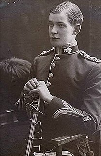
Belgrave Edward Sutton Ninnis was an English officer in the Royal Fusiliers and an Antarctic explorer who was a member of Douglas Mawson's 1911 Australasian Antarctic expedition.
Aurora Peak is an Antarctic peak 535 metres (1,755 ft) high along the west side of the Mertz Glacier, 4 miles (6 km) south of Mount Murchison. It was discovered by the Australasian Antarctic Expedition (1911–14) under Douglas Mawson. The members of the eastern coastal party named it after the expedition ship Aurora [1].
The Gillies Islands are three small, rocky islands protruding above Shackleton Ice Shelf 3 nautical miles (6 km) north of Cape Moyes.
Cape Hoadley is a prominent rock coastal outcrop forming the west portal of the valley occupied by Scott Glacier in East Antarctica. It was discovered by the Western Base Party of the Australasian Antarctic Expedition under Mawson in November 1912, and named by him for C.A. Hoadley, a geologist with the party.
Kennedy Peak is a small peak protruding above the continental ice 2 nautical miles (4 km) south of Mount Barr Smith, on the west side of Denman Glacier, Antarctica. It was mapped from air photos taken by U.S. Navy Operation Highjump, 1946–47, and named by the Advisory Committee on Antarctic Names (US-ACAN) for A.L. Kennedy, a cartographer with the Australasian Antarctic Expedition Western Base party, in recognition of the close correlation of his 1912–13 running survey of the eastern half of the Queen Mary Coast with the US-ACAN map of 1955 compiled from aerial photographs.
Roscoe Glacier is an Antarctic channel glacier, 12 nautical miles (22 km) long and 3 to 5 nautical miles (9 km) wide, debouching from a small valley onto the west portion of Shackleton Ice Shelf, midway between Cape Moyes and Junction Corner. Charted as a valley depression during a southern reconnaissance in March 1912 by F. Wild and other members of the Western Base Party of the Australasian Antarctic Expedition under Mawson. Delineated from aerial photographs taken by U.S. Navy Operation Highjump, 1946–47, and named by the Advisory Committee on Antarctic Names (US-ACAN) for John H. Roscoe, geographer, author of Antarctic Bibliography, and scientific advisor to the director of United States Antarctic Program. Roscoe served as photogrammetrist with the central task group of U.S. Navy Operation Highjump, 1946–47, and with U.S. Navy Operation Windmill, 1947–48, and assisted the latter group in establishing astronomical control stations along Wilhelm II, Queen Mary, Knox and Budd Coasts.

The air-tractor sledge was a converted fixed-wing aircraft taken on the 1911–1914 Australasian Antarctic Expedition, the first plane to be taken to the Antarctic.

Leslie Hatton Whetter ; was a surgeon and Antarctic explorer from New Zealand. A graduate of the University of Otago, in 1911 he joined the Australasian Antarctic Expedition (AAE), led by Douglas Mawson. During 1912, Whetter joined two sledging parties, the first to lay supplies, and the second to explore the area to the west of the Main Base at Cape Denison. On the second expedition, his party of three man-hauled a sledge 158 miles (254 km) from the Cape Denison base, and in the process discovered the first meteorite to be found in Antarctica. Mawson thought Whetter lazy, and the two clashed several times, Mawson describing Whetter as "not fit for a polar expedition".

The Far Eastern Party was a sledging component of the 1911–1914 Australasian Antarctic expedition, which investigated the previously unexplored coastal regions of Antarctica west of Cape Adare. Led by Douglas Mawson, the party aimed to explore the area far to the east of their main base in Adélie Land, pushing about 500 miles (800 km) towards Victoria Land. Accompanying Mawson were Belgrave Edward Ninnis, a lieutenant in the Royal Fusiliers, and Swiss ski expert Xavier Mertz; the party used sledge dogs to increase their speed across the ice. Initially they made good progress, crossing two huge glaciers on their route south-east.

Percy Correll (1892–1974) was a mechanic and an assistant physicist on Sir Douglas Mawson's scientific expedition to Antarctica from 1911–1914, the Australasian Antarctic Expedition.

In common with many of the expeditions of the Heroic Age, Douglas Mawson's Australasian Antarctic Expedition (AAE) employed dog-hauled sledges as a principal means of transportation during exploration of the continent. Dog sledges could carry more weight and travel faster than man-hauled sledges; they were more reliable in the freezing temperatures than motor-sledges; and dogs had proved to be more adaptable to harsh Antarctic conditions than ponies.

