
Kīlauea is an active shield volcano in the Hawaiian Islands. It is located along the southeastern shore of Hawaii Island. The volcano is between 210,000 and 280,000 years old and grew above sea level about 100,000 years ago. Since the islands were settled it has been the most active of the five volcanoes that together form the island.

Chatham Lighthouse, known as Twin Lights prior to 1923, is a lighthouse in Chatham, Massachusetts, near the "elbow" of Cape Cod. The original station, close to the shore, was built in 1808 with two wooden towers, which were both replaced in 1841. In 1877, two new towers, made of cast iron rings, replaced those. One of the towers was moved to the Eastham area, where it became known as Nauset Light in 1923.

Cape Poge Light, sometimes called Cape Pogue Light, is at the northeast tip of Chappaquiddick Island that is part of Martha's Vineyard, off the coast of Cape Cod, Massachusetts.
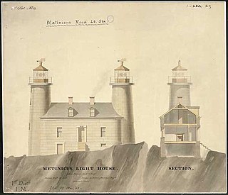
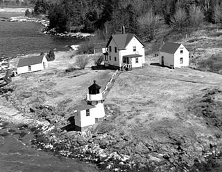
Matinicus Rock Light is a lighthouse on Matinicus Rock, a windswept rock 25 miles (40 km) off the coast of Maine. It is one of eleven seacoast lights off the coast of Maine. First established in 1827, the present surviving structures date to 1857. The lighthouse was added to the National Register of Historic Places as Matinicus Rock Light Station on March 14, 1988.

Goat Island Light is a lighthouse located off Cape Porpoise near Kennebunkport in southern Maine. Goat Island Light was established in 1835 to guard the entrance to Cape Porpoise Harbor. The original station was upgraded in 1859 to the current brick tower with a fifth order Fresnel lens. Keeper's quarters were added to the island in 1860. The light station was automated by the United States Coast Guard in 1990 and is currently active. The keepers dwellings and tower are leased to the Kennebunkport Conservation Trust. Goat Island Light can be seen from shore in Cape Porpoise Harbor just off State Route 9 north of Kennebunkport or is viewable by boat. The island is currently closed to the public except by special arrangement.
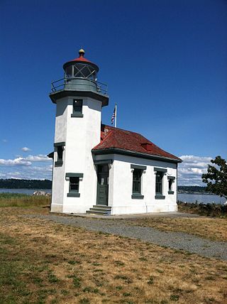
The Point Robinson Light is an operational aid to navigation and historic lighthouse on Puget Sound, located at Point Robinson, the easternmost point of Maury Island, King County, in the U.S. state of Washington. The site was listed on the National Register of Historic Places in 2004.
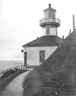
Cape Sarichef Light is a lighthouse located on the northwest tip of Unimak Island, approximately 630 miles (1,010 km) southwest of Anchorage, Alaska. The most westerly and most isolated lighthouse in North America, Cape Sarichef Light marks the northwest end of Unimak Pass, the main passage through the Aleutian Islands between the Bering Sea and the Pacific Ocean. When it was first lit on July 1, 1904, it was Alaska's second coastal lighthouse, and the only staffed U.S. lighthouse on the Bering Sea. Today, the lighthouse is automated, and the beacon is mounted on a skeleton tower.
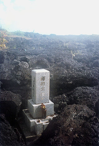
Kapoho, Hawaii, is a now-uninhabited unincorporated area in Puna district, Hawaii County, Hawaii, US, located near the eastern tip of the island of Hawaii, in the easternmost subaerial end of the graben overlying Kīlauea's east rift zone. Originally destroyed by an eruption of Kīlauea in 1960, it was rebuilt as a community of private homes and vacation rentals. The town was again destroyed by lava during the 2018 lower Puna eruption, this time with the bay largely buried by lava as well.

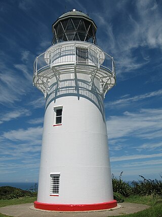
The Daniel K. Inouye Kīlauea Point Lighthouse, also known as Kīlauea Light, is a lighthouse located on Kīlauea Point on the island of Kauaʻi, Hawaiʻi in the Kīlauea Point National Wildlife Refuge.
Access to Otiki Hill passes through private property, and since November 2021 has been restricted - owing to Covid-19 concerns. The current advice is not to travel to the cape until further notice.

Bakers Island Light is a historic lighthouse on Bakers Island in Salem, Massachusetts. The station was originally established in 1791, with a daymark. This was replaced in 1798 by two lights atop a keeper's house, one at each end. After storm damage in 1815, an octagonal stone tower was constructed. The current round stone tower was added in 1820. The 1820 tower was taller, leading to the names "Ma" and "Pa". The two remained in service until 1926, when the older, shorter tower was removed.

Annisquam Harbor Light Station is a historic lighthouse on Wigwam Point in the Annisquam neighborhood of Gloucester, Massachusetts. It can be viewed from nearby Wingaersheek Beach, Gloucester. It lies on the Annisquam River and is one of the four oldest lighthouses to surround the Gloucester peninsula as well as; Eastern Point Light, Ten Pound Island Light, and Thacher Island Light.

Deer Isle Thorofare Light, also known as Mark Island Light, is a lighthouse on Penobscot Bay, Maine, about 1.8 nautical miles west-southwest of Stonington. It was built in 1857.

Little River Light is a lighthouse on an island at the mouth of the Little River, in Cutler, Maine. A light station was first established at this site in 1846, and the present structure was built in 1876. It is one of the only iron lighthouses in the state, and was listed on the National Register of Historic Places as Little River Light Station on March 14, 1988. The light station is now owned by the American Lighthouse Foundation, which offers overnight stays in the keeper's house, and occasional tours of the property.
Squirrel Point Light is a lighthouse marking the southwestern point of Arrowsic Island on the Kennebec River. It was established in 1898, as part of a major upgrade of the river's lights — the Doubling Point Light and the separate Range Lights on the point, Perkins Island Light, and Squirrel Point Light were all built at the same time. The light station was listed on the National Register of Historic Places as Squirrel Point Light Station on January 21, 1988.

Cape Scott Lighthouse is at the northwestern extremity of Vancouver Island, British Columbia.


