Cape Simpson (Greenland)

Last updated
Cape Simpson
Kap Simpson
Greenland edcp location map.svg
Red pog.svg
Cape Simpson
Coordinates: 72°7′N22°15′W / 72.117°N 22.250°W / 72.117; -22.250
LocationNE Greenland
Offshore water bodies Davy Sound
Greenland Sea
Area
  Total Arctic
Elevation729 m (2,392 ft)

Cape Simpson (Danish : Kap Simpson) is a headland in the Greenland Sea, Northeast Greenland. Administratively it is part of the Northeast Greenland National Park.

Contents

History

This headland was named "Cape Simpson" in 1822 by William Scoresby (1789 – 1857). [1] Numerous remains of former Inuit habitation were found at that time in the area near the cape. [2]

Materials for a Norwegian hunting station known as "Simpson Stranda" were brought to the area of the headland by Norwegian ship Veslekari in 1929, but the hut was never built. Another hut, "Kap Simpson Hytte", was built by the Sirius Dog Sled Patrol between 1955 and 1956. [1]

Geography

Cape Simpson is located in the Greenland Sea, north of Cape Biot on the opposite side of the mouth of Davy Sound. [3]

Cape Simpson rises at the southeastern end of Traill Island, whose shore trending northwest of the cape forms the northeastern coast of Davy Sound. It is a conspicuous headland. The Vandyke Cliffs, steep and displaying multicolored strata, rise above the cape at a sheer angle right from the shore. Dream Bay (Drømmebugten) is located about 14 km (8.7 mi) WNW of the headland and larger Mountnorris Fjord to the northeast. Most of the years the sea around the cape is filled with ice, even in the summer. [4]

Map of NE Greenland and Iceland. Operational Navigation Chart C-1, 1st edition.jpg
Map of NE Greenland and Iceland.

Bibliography

See also

Related Research Articles

<span class="mw-page-title-main">Traill Island</span>

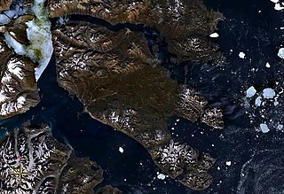
Traill Island is a large island in eastern Greenland. It is named after zoologist Thomas Stewart Traill. The island is a part of the Northeast Greenland National Park.

<span class="mw-page-title-main">Cape Hope</span> Headland in east Greenland

Cape Hope is a headland in the Scoresby Sound, east Greenland, Sermersooq municipality.

Cape Atholl, also known as Kangaarasuk, is a headland in Northwest Greenland, Avannaata municipality.

<span class="mw-page-title-main">Cape Brewster</span> Headland in Sermersooq, Greenland

Cape Brewster is a headland in the Greenland Sea, east Greenland, Sermersooq municipality.

Cape Nansen is a headland in the Greenland Sea, east Greenland, Sermersooq municipality. This cape is named after Fridtjof Nansen. Cape Nansen is an important geographical landmark.

Cape Cort Adelaer, also known as Cape Adelaer, is a headland in the North Atlantic Ocean, southeast Greenland, Sermersooq municipality. This cape is named after Norwegian seaman Cort Adeler (1622–1675) who distinguished himself for services rendered to the Royal Dano-Norwegian Navy.

<span class="mw-page-title-main">Cape Bridgman</span> Headland in northeast Greenland

Cape Bridgman is a headland in the Wandel Sea, Arctic Ocean, northeast Greenland.

Segelsällskapet Fjord is a fjord in King Christian X Land, eastern Greenland.

<span class="mw-page-title-main">Antarctic Haven</span>

Antarctic Haven is a bay in King Christian X Land, Northeastern Greenland.

Fleming Fjord is a fjord in King Christian X Land, eastern Greenland.

Cape Møsting is a headland in the North Atlantic Ocean, southeast Greenland, Kujalleq municipality.

<span class="mw-page-title-main">Cape Moltke</span> Headland in southeast Greenland

Cape Moltke is a headland in the North Atlantic Ocean, southeast Greenland, Kujalleq municipality.

Cape Brown is a headland in the Greenland Sea, east Greenland, Sermersooq municipality.

Cape Biot is a headland in the Greenland Sea, Northeast Greenland, Sermersooq municipality.

<span class="mw-page-title-main">Davy Sound</span>

The Davy Sound is a sound in King Christian X Land, Northeast Greenland. Administratively it is part of the Northeast Greenland National Park zone.

<span class="mw-page-title-main">Mackenzie Bay</span>

Mackenzie Bay is a bay of the Greenland Sea in King Christian X Land, Greenland. Administratively it belongs to the NE Greenland National Park area.

Cape Bismarck is a headland in King Frederick VIII Land, Northeast Greenland. Administratively it is part of the Northeast Greenland National Park.

<span class="mw-page-title-main">Cape Clarence Wyckoff</span> Headland in northern Greenland

Cape Clarence Wyckoff, also known as Cape Wyckoff, is a broad headland in the Wandel Sea, Arctic Ocean, northernmost Greenland. Administratively it is part of the Northeast Greenland National Park.

<span class="mw-page-title-main">Cape Henry Parish</span> Headland in Greenland

Cape Henry Parish is a broad headland in the Wandel Sea, Arctic Ocean, northernmost Greenland. Administratively it is part of the Northeast Greenland National Park.

<span class="mw-page-title-main">Herluf Trolle Land</span>

Herluf Trolle Land is an area in Peary Land, North Greenland. Administratively it is part of the Northeast Greenland National Park.

References

  1. 1 2 Place names, NE Greenland
  2. William Scoresby, Journal of a Voyage to the Northern Whale-Fishery. Including Researches and Discoveries on the Eastern Coast of West Greenland, p. 253-267
  3. "Kap Simpson". Mapcarta. Retrieved 17 August 2019.
  4. Prostar Sailing Directions 2005 Greenland and Iceland Enroute, p. 118