
Sir Douglas Mawson was a British-born Australian geologist, Antarctic explorer, and academic. Along with Roald Amundsen, Robert Falcon Scott, and Sir Ernest Shackleton, he was a key expedition leader during the Heroic Age of Antarctic Exploration.

Mawson Station, commonly called Mawson, is one of three permanent bases and research outposts in Antarctica managed by the Australian Antarctic Division (AAD). Mawson lies in Holme Bay in Mac. Robertson Land, East Antarctica in the Australian Antarctic Territory, a territory claimed by Australia. Established in 1954, Mawson is Australia's oldest Antarctic station and the oldest continuously inhabited Antarctic station south of the Antarctic Circle. It houses approximately 20 personnel over winter and up to 53 in summer.

Mac. Robertson Land is the portion of Antarctica lying southward of the coast between William Scoresby Bay and Cape Darnley. It is located at 70°00′S65°00′E. In the east, Mac. Robertson Land includes the Prince Charles Mountains. It was named by the British Australian and New Zealand Antarctic Research Expedition (BANZARE) (1929–1931), under Sir Douglas Mawson, after Sir Macpherson Robertson of Melbourne, a patron of the expedition.
Scott Glacier is a glacier, 7 miles (11.3 km) wide and over 20 miles (32 km) long, flowing north-northwest to the Antarctic coast between Denman Glacier and Mill Island. It was discovered by the Western Base Party of the Australasian Antarctic Expedition (1911–1914) under Mawson and named for Capt. Robert F. Scott.

Queen Mary Land or the Queen Mary Coast is the portion of the coast of Antarctica lying between Cape Filchner, in 91° 54' E, and Cape Hordern, at 100° 30' E. It is claimed by Australia as part of the Australian Antarctic Territory.
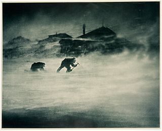
Cape Denison is a rocky point at the head of Commonwealth Bay in George V Land, Antarctica. It was discovered in 1912 by the Australasian Antarctic Expedition (1911–14) under Douglas Mawson, who named it for Sir Hugh Denison of Sydney, a patron of the expedition. The cape was the site of the expedition's main base. Called by Mawson "the windiest place on Earth", the site experiences fierce katabatic winds.
Mawson Peninsula is a high, narrow, ice-covered peninsula on the George V Coast, on the west side of the Slava Ice Shelf, Antarctica, terminating in Cape Hudson. It extends for over 30 nautical miles (56 km) in a northwesterly direction. The peninsula was photographed from the air by U.S. Navy Operation Highjump, 1946–47, and was sketched and photographed by Phillip Law of the Australian National Antarctic Research Expeditions who flew along it to its northern end in February 1959. It was named by the Antarctic Names Committee of Australia for Sir Douglas Mawson.
Cape Ann is a cape on the coast of East Antarctica, surmounted by Mount Biscoe rising to a peak of 700 metres.
The Scott Mountains are a large number of isolated peaks lying south of Amundsen Bay in Enderby Land of East Antarctica, Antarctica. Discovered on 13 January 1930 by the British Australian New Zealand Antarctic Research Expedition (BANZARE) under Sir Douglas Mawson. He named the feature Scott Range after Captain Robert Falcon Scott, Royal Navy. The term mountains is considered more appropriate because of the isolation of its individual features.

The Australasian Antarctic Expedition was a 1911–1914 expedition headed by Douglas Mawson that explored the largely uncharted Antarctic coast due south of Australia. Mawson had been inspired to lead his own venture by his experiences on Ernest Shackleton's Nimrod expedition in 1907–1909. During its time in Antarctica, the expedition's sledging parties covered around 4,180 kilometres (2,600 mi) of unexplored territory, while its ship, SY Aurora, navigated 2,900 kilometres (1,800 mi) of unmapped coastline. Scientific activities included meteorological measurements, magnetic observations, an expansive oceanographic program, and the collection of many biological and geological samples, including the discovery of the first meteorite found in Antarctica. The expedition was the first to establish and maintain wireless contact between Antarctica and Australia. Another planned innovation – the use of an aircraft – was thwarted by an accident before the expedition sailed. The plane's fuselage was adapted to form a motorised sledge or "air-tractor", but it proved to be of very limited usefulness.
Mawson's Huts are the collection of buildings located at Cape Denison, Commonwealth Bay, in the far eastern sector of the Australian Antarctic Territory, some 3000 km south of Hobart. The buildings were erected and occupied by the Australasian Antarctic Expedition (AAE) of 1911–1914, led by geologist and explorer Sir Douglas Mawson.
Ufs Island is a rocky island 3.2 km (2 mi) wide, lying in the east part of Howard Bay, Antarctica, just north of the Lachal Bluffs, and about 4 km (2.5 mi) west of Allison Bay. Cape Simpson, the north end of this island, was discovered by the British Australian New Zealand Antarctic Research Expedition (BANZARE) under Mawson in February 1931, but the feature's insularity was first recognized by Norwegian cartographers working from aerial photographs taken by the Lars Christensen Expedition, 1936–37. They named it Ufsoy.

The Western Base Party was a successful exploration party of the Australasian Antarctic Expedition. The eight-man Western Party was deposited by the SY Aurora on the Shackleton Ice Shelf at Queen Mary Land. The leader of the team was Frank Wild and the party included the geologist Charles Hoadley.

Cape Batterbee is a small, rocky point on the coast, the most northerly cape of Enderby Land. It is located 92 km north of Mount Elkins.
Cape Bruce forms the northern tip of a small island lying at the eastern side of Oom Bay, separated from the mainland rocks just west of Taylor Glacier in Mac. Robertson Land, Antarctica.

Cape Jules is a rocky cape with a small cove along its northern end, 3 nautical miles (6 km) west of Zelee Glacier Tongue, Antarctica. It was discovered and named by the French expedition under Dumont d'Urville, 1837–40. Jules is the given name of the discoverer, Captain Jules Dumont d'Urville, as well as his son. The area was charted by the Australasian Antarctic Expedition in 1912–13, and again by the British Australian and New Zealand Antarctic Research Expedition in 1931, both under Mawson. The French Antarctic Expedition under Michel Barre established astronomical control at this locality in 1951.
Mill Peak is a prominent peak, 1,760 metres (5,770 ft) high, rising above the Antarctic ice sheet 10 nautical miles (19 km) south of Pearce Peak and 30 nautical miles (56 km) south of Cape Simpson. it was discovered in February 1931 by the British Australian New Zealand Antarctic Research Expedition under Douglas Mawson, who named it for Dr. Hugh Robert Mill.
Cape Hunter is a rocky promontory on the west shore of Commonwealth Bay, Antarctica, 8 nautical miles (15 km) west of Cape Denison. It was discovered in 1912 and explored the following year by the Australasian Antarctic Expedition under Douglas Mawson, who named it for John G. Hunter, chief biologist of the expedition.
The Mawson Glacier is a large glacier on the east coast of Victoria Land, Antarctica, descending eastward from the Antarctic Plateau to the north of Trinity Nunatak and the Kirkwood Range, to enter the Ross Sea, where it forms the Nordenskjöld Ice Tongue. The glacier was first mapped by the British Antarctic Expedition (1907–09) and named for Douglas Mawson, the expedition physicist, who later led two other Antarctic expeditions, 1911–14, and 1929–31.
Cape Mawson is a low, ice-covered cape forming the southeastern extremity of Charcot Island, Antarctica. It was first seen from the air and roughly charted by Sir Hubert Wilkins on December 29, 1929, in a flight made around the island. The cape was named by Wilkins for Australian Antarctic explorer Sir Douglas Mawson, the leader of the Australasian Antarctic Expedition, 1911–14, and the British Australian New Zealand Antarctic Research Expedition, 1929–31. It was remapped in 1960 by D. Searle of the Falkland Islands Dependencies Survey from air photos taken by U.S. Navy Operation Highjump in 1947.
