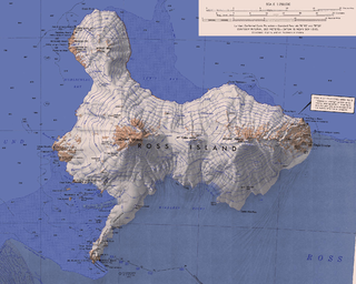
Ross Island is an island formed by four volcanoes in the Ross Sea near the continent of Antarctica, off the coast of Victoria Land in McMurdo Sound. Ross Island lies within the boundaries of Ross Dependency, an area of Antarctica claimed by New Zealand.

Sturge Island is one of the three main islands in the uninhabited Balleny Islands group located in the Southern Ocean. It lies 25 km (16 mi) southeast of Buckle Island and 95 km (59 mi) north-east of Belousov Point on the Antarctic mainland. The island, in Oates Land, also forms part of the Ross Dependency, claimed by New Zealand.

Mount Terror is a large shield volcano that forms the eastern part of Ross Island, Antarctica. It has numerous cinder cones and domes on the flanks of the shield and is mostly under snow and ice. It is the second largest of the four volcanoes that make up Ross Island and is somewhat overshadowed by its neighbour, Mount Erebus, 30 km (19 mi) to the west. Mount Terror was named in 1841 by Sir James Clark Ross for his second ship, HMS Terror. The captain of Terror was Francis Crozier, a close friend of Ross for whom the nearby Cape Crozier is named.

This is a list of the extreme points of North America: the points that are highest and lowest, and farther north, south, east or west than any other location on the continent. Some of these points are debatable, given the varying definitions of North America.

King William Island is an island in the Kitikmeot Region of Nunavut, which is part of the Arctic Archipelago. In area it is between 12,516 km2 (4,832 sq mi) and 13,111 km2 (5,062 sq mi) making it the 61st-largest island in the world and Canada's 15th-largest island. Its population, as of the 2021 census, was 1,349, all of whom live in the island's only community, Gjoa Haven.

Queen Charlotte Sound is a sound of the Pacific Ocean in British Columbia, Canada, between Vancouver Island in the south and Haida Gwaii in the north. It merges with Hecate Strait in the north and Queen Charlotte Strait in the south.
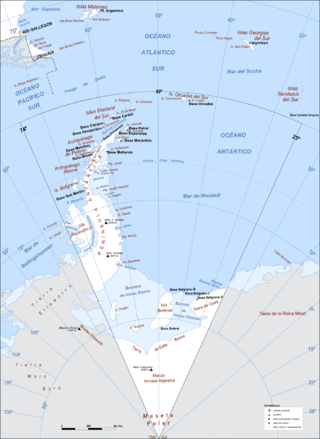
This is a list of extreme points in Antarctica.
This is a list of the extreme points of The Americas, the points that are farther north, south, east or west than any other location on the continent. The continent's southernmost point is often said to be Cape Horn, which is the southernmost point of the Chilean islands. The Americas cross 134° of longitude east to west and 124° of latitude north to south.

Hut Point Peninsula is a long, narrow peninsula from 3 to 5 km wide and 24 km (15 mi) long, projecting south-west from the slopes of Mount Erebus on Ross Island, Antarctica. McMurdo Station (US) and Scott Base (NZ) are Antarctic research stations located on the Hut Point Peninsula.

USC&GS Yukon was a schooner that served as a survey ship in the United States Coast Survey from 1873 to 1878 and in its successor agency, the United States Coast and Geodetic Survey, from 1878 to 1894. She was the pioneering Coast Survey ship in many of the waters of the Territory of Alaska, including the Bering Sea and the western Aleutian Islands, and she also operated extensively in California and Washington. She later entered commercial service as Elwood and was wrecked in 1895.

Cape Muzon is a cape located in the Alexander Archipelago of the U.S. state of Alaska. It is the southernmost point of Dall Island and the headland marking the northwestern extremity of the Dixon Entrance. The boundary line separating Alaska from Canada runs very close to Cape Muzon, although according to the Alaska Boundary Treaty Cape Muzon is defined precisely as the western end of the so-called A-B Line, part of the Canada–United States border.

The borders of the oceans are the limits of Earth's oceanic waters. The definition and number of oceans can vary depending on the adopted criteria. The principal divisions of the five oceans are the Pacific Ocean, Atlantic Ocean, Indian Ocean, Southern (Antarctic) Ocean, and Arctic Ocean. Smaller regions of the oceans are called seas, gulfs, bays, straits, and other terms. Geologically, an ocean is an area of oceanic crust covered by water.
Cape Frances is a cape on the east side of Sturge Island in the Balleny Islands. In 1841, Captain James C. Ross, viewing Sturge Island from a considerable distance, thought it a group of three islands and named the center island, Frances. This error was discovered in 1904 by Captain Robert F. Scott, who applied the name to this cape.
Cape Freeman is a cape forming the north end of Sturge Island in the Balleny Islands. It was named for H. Freeman, commander of the cutter Sabrina, which sailed with the schooner Eliza Scott, resulting in the discovery of the Balleny Islands in 1839.

USRC Wolcott, the second ship of the name, sometimes referred to as USRC Oliver Wolcott, was a revenue cutter in commission in the United States Revenue-Marine from 1873 to 1894 and in the United States Revenue Cutter Service from 1894 to 1897. She served in the waters of the Territory of Alaska during her career. After her revenue cutter service, she operated as a merchant vessel until she was wrecked in 1900.
![]() This article incorporates public domain material from "Cape Smyth". Geographic Names Information System . United States Geological Survey. [1] [2]
This article incorporates public domain material from "Cape Smyth". Geographic Names Information System . United States Geological Survey. [1] [2] 


