
The Cape Verde Rise is an oceanic feature that includes the Cape Verde Islands and the areas north and east of the islands and west of the African Continental Shelf as well as Mauritania and Senegal.
Contents
The Cape Verde Rise is an oceanic feature that includes the Cape Verde Islands and the areas north and east of the islands and west of the African Continental Shelf as well as Mauritania and Senegal.
The rise are bounded by the Canary Basin to the north and the Cape Verde Basin to the south. Numerous seamounts are located in the rise including the Cape Verde (or Cabo Verde) (Latin: sometimes as Extracapitis being off the cape), Cadamosto, Boa Vista, Nola and Senghor. The third and fourth are named after explorers of Cape Verde, the other, the founding father of Senegal. The highest point is 2,220 meters below sea level and the deepest is in the range of over 3,000 meters deep. In the east end of the rise is the Dakar Canyon. It ranges between the 14 and the 22° parallels north and is 900 km long. Near the rise is the westernmost point in Africa, Cap-Vert, northwest of the rise is the Santo Antão Ridge.
In the waters above the Cape Verde Rise is the Canary (or Canarian) Current to the north and the Equatorial Atlantic Current around the south of the rise.
Nola Seamount may be the tallest seamount within Cape Verde with its elevation ranging from 60–70 meters deep, and probably the Cape Verde Rise.
Over 1,500 km west of the rise are two fracture zones located at the Mid-Atlantic Ridge, the Kane, the Fifteen-Twenty and Jacksonville.
In the rise there are 13 smaller fracture zones, three extends as far as the Cape Verde Basin and another extends north into the Canary Basin and within the Canary Islands. [1]
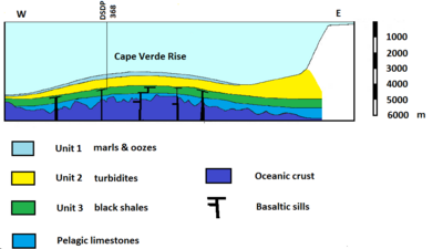
In the course of the Deep Sea Drilling Project and the Ocean Drilling Program, two research drillings were done so far, the DSDP 368 and the ODP 659. At the DSDP 368 location which was drilled 985 meters deep, it is divided into three units, the first unit composes of marls and oozes, the second composes of turbidites and the third composes of black shales, they lie above pelagic limestones and the oceanic crust. In that area are five basaltic sills. DSDP 368 is east of the island of Boa Vista.
The oldest rocks dates back to 155 million years ago during the Kimmeridgian era in the area what is now the east of the rise, around 131 to 128 million years ago, the seamounts of Maio and Santiago were formed, [2] at the time they were closer to the Mid-Atlantic Ridge. The spreading rate was slow and moved a centimeter a year.
Between 15 and 7 million years ago, they were volcanically active. Its only volcanic activities in the basin are in Fogo, Brava and the Cadamosto Seamount. [3] Brava's last eruption was in the Holocene era.
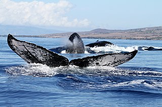
In the waters above the rise, eighteen species of whales and dolphins have been recorded in the waters of the Cape Verde archipelago. [4] The area is cited as one of two known breeding grounds for the humpback whale (Megaptera novaeangliae) of the Northern Hemisphere. [5] Humpback whales migrate annually from the North Sea to winter around Cape Verde from January to mid-May. The humpback whale population became limited due to severe overfishing during the 19th century and, although the total North Atlantic population of humpbacks had rebounded to more than 10,000 individuals by 1993, the Cape Verde population remained uncertain as of 2009. [5]
Molluscs (Mollusks) in the deep waters within the Cape Verde islands include Tiberia apicifusca at depths between 273 m and 970 m below sea level.

The recorded history of Cape Verde begins with the Portuguese discovery of the island in 1458. Possible early references to Cape Verde date back at least 2,000 years.

The humpback whale is a species of baleen whale. It is a rorqual and is the only species in the genus Megaptera. Adults range in length from 14–17 m (46–56 ft) and weigh up to 40 metric tons. The humpback has a distinctive body shape, with long pectoral fins and tubercles on its head. It is known for breaching and other distinctive surface behaviors, making it popular with whale watchers. Males produce a complex song typically lasting 4 to 33 minutes.
Louis Herman was an American marine biologist. He was a researcher of dolphin sensory abilities, dolphin cognition, and humpback whales. He was professor in the Department of Psychology and a cooperating faculty member of the Department of Oceanography at the University of Hawaiʻi at Mānoa. He founded the Kewalo Basin Marine Mammal Laboratory (KBMML) in Honolulu, Hawaii in 1970 to study bottlenose dolphin perception, cognition, and communication. In 1975, he pioneered the scientific study of the annual winter migration of humpback whales into Hawaiian waters. Together with Adam Pack, he founded The Dolphin Institute in 1993, a non-profit corporation dedicated to dolphins and whales through education, research, and conservation.

The Cariaco Basin lies off the north central coast of Venezuela and forms the Gulf of Cariaco. It is bounded on the east by Margarita Island, Cubagua Island, and the Araya Peninsula; on the north by Tortuga Island and the Tortuga Banks; on the west by Cape Codera and the rocks known as Farallón Centinela; and on the south by the coast of Venezuela.

The wildlife of Cape Verde is found across its archipelago of ten islands and three islets, albeit in smaller numbers of species than mainland Africa. Each volcanic island within the archipelago is unique, and each of them have parks under their jurisdiction, by decree promulgated by the Cape Verde government. Located just off the west coast of Africa, the total land area of the island nation is 4,564 square kilometres (1,762 sq mi).

The Northwest Shelf Transition, also known as Bonaparte Coast, is a biogeographic region of Australia's continental shelf. It adjoins the Kimberley region of Western Australia and the adjacent coast of the Northern Territory.

The following outline is provided as an overview of and introduction to Oceanography.
The Hawaiian Islands Humpback Whale National Marine Sanctuary is one of the world's most important whale habitats, hosting thousands of humpbacks each winter.
The Fogo Seamounts, also called the Fogo Seamount Chain, are a group of undersea mountains southeast of the Grand Banks of Newfoundland in the North Atlantic Ocean. This seamount chain, lying approximately 500 km (310 mi) offshore from the island of Newfoundland, consists of several submarine volcanoes that have been extinct for millions of years. They are one of the few seamount chains located in Canadian waters off the coast of Atlantic Canada.

The volcanism of Eastern Canada includes the hundreds of volcanic areas and extensive lava formations in Eastern Canada. The region's different volcano and lava types originate from different tectonic settings and types of volcanic eruptions, ranging from passive lava eruptions to violent explosive eruptions. Eastern Canada has very large volumes of magmatic rock called large igneous provinces. They are represented by deep-level plumbing systems consisting of giant dike swarms, sill provinces and layered intrusions. The most capable large igneous provinces in Eastern Canada are Archean age greenstone belts containing a rare volcanic rock called komatiite.

Lithophaga aristata, or the Scissor date mussel, is a species of bivalve mollusc in the family Mytilidae. It can be found along the Atlantic coast of North America, ranging from North Carolina to Texas and the West Indies.

The DSDP 368 was an area that was drilled as part of the Deep Sea Drilling Project that took place below the Cape Verde Rise.

The DSDP 367 was an area that was drilled as part of the Deep Sea Drilling Project that took place below the Cape Verde Basin.
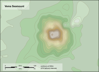
Vema Seamount is a seamount in the South Atlantic Ocean. Discovered in 1959 by a ship with the same name, it lies 1,600 kilometres (1,000 mi) from Tristan da Cunha and 1,000 kilometres (620 mi) northwest of Cape Town. The seamount has a flat top at a mean depth of 73 metres which was eroded into the seamount at a time when sea levels were lower; the shallowest point lies at 26 metres depth. The seamount was formed between 15-11 million years ago, possibly by a hotspot.

Horizon Guyot is a presumably Cretaceous guyot (tablemount) in the Mid-Pacific Mountains, Pacific Ocean. It is an elongated ridge, over 300 kilometres (190 mi) long and 4.3 kilometres (2.7 mi) high, that stretches in a northeast–southwest direction and has two flat tops; it rises to a minimum depth of 1,443 metres (4,730 ft). The Mid-Pacific Mountains lie west of Hawaii and northeast of the Line Islands.
Madeira Abyssal Plain, also called Madeira Plain, is an abyssal plain situated at the center and deepest part of the Canary Basin. It is a north-northeast to south-southeast elongated basin that almost parallels the Mid-Atlantic Ridge. Its western boundary is marked by a chain of seamounts known as the either Seewarte Seamounts or Atlantis-Great Meteor Seamount Chain. Its eastern boundary is a distinct break of slope that marks the foot of the African Continental Rise. This abyssal plain occupies an area of about 68,000 km2 (26,000 sq mi). Across this basin, slope angles are generally less than 0.01°.
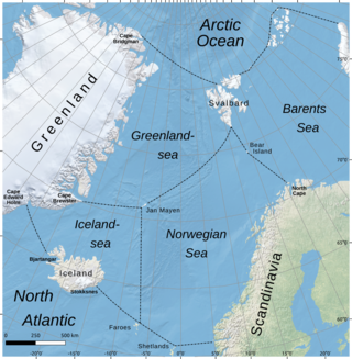
The Iceland Sea, a relatively small body of water, is bounded by Iceland. It is characterized by its proximity to the Mid-Atlantic Ridge, which transforms into the Kolbeinsey Ridge, and the Greenland-Scotland Ridge, and it lies just south of the Arctic Circle. This region is typically delineated by Greenland to the west, the Denmark Strait, and the continental shelf break south of Iceland to the south. Next in the boundary line are Jan Mayen, being a small Norwegian volcanic island, and the Jan Mayen Fracture Zone to the north, with the Jan Mayen Ridge to the east of the sea. This ridge serves as the northern boundary of the Iceland Sea, acting as the dividing line from the Greenland Sea. To the immediate south of Jan Mayen, the Iceland-Jan Mayen Ridge stretches towards the Iceland-Faroe Ridge, creating a boundary between the Iceland Sea and the Norwegian Sea to the east.

Cadamosto Seamount is a seamount in the Cape Verde islands, 25 kilometres (16 mi) southwest of Brava. It rises to a depth of 1,380 metres (4,530 ft) and partially overlaps with Brava. The seamount appears to be one of the recently active volcanic centres of the Cape Verde islands and has produced phonolite. The seamount has had intense volcanic eruptions in the late Pleistocene, and recent seismic activity indicates that volcanism is ongoing.

Migaloo is an all-white humpback whale that was first sighted on the 28 June 1991 at the Australian east coast near Byron Bay.