The Deep Sea Drilling Project (DSDP) was an ocean drilling project operated from 1968 to 1983. The program was a success, as evidenced by the data and publications that have resulted from it. The data are now hosted by Texas A&M University, although the program was coordinated by the Scripps Institution of Oceanography at the University of California, San Diego. DSDP provided crucial data to support the seafloor spreading hypothesis and helped to prove the theory of plate tectonics. DSDP was the first of three international scientific ocean drilling programs that have operated over more than 40 years. It was followed by the Ocean Drilling Program (ODP) in 1985, the Integrated Ocean Drilling Program in 2004 and the present International Ocean Discovery Program in 2013.
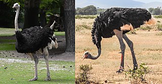
Ostriches are large flightless birds. Two living species are recognised, the common ostrich, native to large areas of sub-Saharan Africa, and the Somali ostrich, native to the Horn of Africa.
The Messinian salinity crisis was a geological event during which the Mediterranean Sea went into a cycle of partial or nearly complete desiccation (drying-up) throughout the latter part of the Messinian age of the Miocene epoch, from 5.96 to 5.33 Ma. It ended with the Zanclean flood, when the Atlantic reclaimed the basin.

The Zanclean is the lowest stage or earliest age on the geologic time scale of the Pliocene. It spans the time between 5.332 ± 0.005 Ma and 3.6 ± 0.005 Ma. It is preceded by the Messinian Age of the Miocene Epoch, and followed by the Piacenzian Age.
The Piacenzian is in the international geologic time scale the upper stage or latest age of the Pliocene. It spans the time between 3.6 ± 0.005 Ma and 2.58 Ma. The Piacenzian is after the Zanclean and is followed by the Gelasian.
Calabrian is a subdivision of the Pleistocene Epoch of the geologic time scale, defined as 1.8 Ma—774,000 years ago ± 5,000 years, a period of ~1.026 million years.

The Molasse basin is a foreland basin north of the Alps which formed during the Oligocene and Miocene epochs. The basin formed as a result of the flexure of the European plate under the weight of the orogenic wedge of the Alps that was forming to the south.

Kotelny Island is part of the Anzhu Islands subgroup of the New Siberian Islands located between the Laptev Sea and the East Siberian Sea in the Russian Arctic. It is administratively and municipally part of Bulunsky District of the Republic of Sakha (Yakutia).
The Hatton Basin is a ca. 600 km long SW–NE trending sedimentary basin, located off the west coast of Ireland. It lies between the Hatton and Edoras Banks to the west and the Rockall Bank to the east. The basin contains about 4,000 m of sediments of probable Cretaceous to Cenozoic age. Its relationship to the Rockall Basin remains uncertain.

The Geology of Bangladesh is affected by the country's location, as Bangladesh is mainly a riverine country. It is the eastern two-thirds of the Ganges and Brahmaputra river delta plain stretching to the north from the Bay of Bengal. There are two small areas of slightly higher land in the north-centre and north-west composed of old alluvium called the Madhupur Tract and the Barind Tract, and steep, folded, hill ranges of older (Tertiary) rocks along the eastern border.
The Orca Basin is a mid-slope, silled, mini-basin in the northern Gulf of Mexico some 300 km southwest of the Mississippi River mouth on the Louisiana continental slope. It is unique amongst the mini-basins in this area, in containing a large brine pool of anoxic salt brine. The pool is approximately 123 km2 (47 sq mi) in area and up to 220 m (720 ft) deep under 2,400 m (7,900 ft) of Gulf water and is derived from dissolution of underlying Jurassic age Louann Salt. With a volume of 13.3 km3 (3.2 cu mi), the pool results from the dissolution of about 3.62 billion tonnes of the Louann Salt bed into seawater. The basin owes its shape to ongoing salt tectonics and is surrounded by salt diapirs.

The Choctaw Sea was a Cenozoic eutropical subsea, which along with the Okeechobean Sea, occupied the eastern Gulf of Mexico basin system bounding Florida.
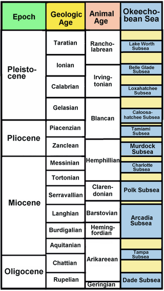
The Okeechobean Sea was a Cenozoic eutropical subsea, which along with the Choctaw Sea, occupied the eastern Gulf of Mexico basin system bounding Florida.
The Tyrrhenian Basin is a sedimentary basin located in the western Mediterranean Sea under the Tyrrhenian Sea. It covers a 231,000 km2 area that is bounded by Sardinia to the west, Corsica to the northwest, Sicily to the southeast, and peninsular Italy to the northeast. The Tyrrhenian basin displays an irregular seafloor marked by several seamounts and two distinct sub-basins - the Vavilov and Marsili basins. The Vavilov deep plain contains the deepest point of the Tyrrhenian basin at approximately 3785 meters. The basin trends roughly northwest–southeast with the spreading axis trending northeast–southwest.
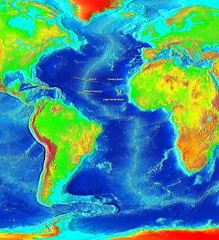
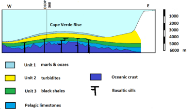
The Cape Verde Rise is an oceanic feature that includes the Cape Verde Islands and the areas north and east of the islands and west of the African Continental Shelf as well as Mauritania and Senegal.

The DSDP 367 was an area that was drilled as part of the Deep Sea Drilling Project that took place below the Cape Verde Basin.
The geology of Greece is highly structurally complex due to its position at the junction between the European and African tectonic plates.
Global paleoclimate indicators are the proxies sensitive to global paleoclimatic environment changes. They are mostly derived from marine sediments. Paleoclimate indicators derived from terrestrial sediments, on the other hand, are commonly influenced by local tectonic movements and paleogeographic variations. Factors governing the Earth's climate system include plate tectonics, which controls the configuration of continents, the interplay between the atmosphere and the ocean, and the Earth's orbital characteristics. Global paleoclimate indicators are established based on the information extracted from the analyses of geologic materials, including biological, geochemical and mineralogical data preserved in marine sediments. Indicators are generally grouped into three categories; paleontological, geochemical and lithological.
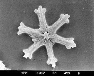
Calcareous nannofossils are a class of tiny microfossils that are similar to coccoliths deposited by the modern-day coccolithophores. The nannofossils are a convenient source of geochronological data due to the abundance and rapid evolution of the single-cell organisms forming them (nannoplankton) and ease of handling of the sediment samples. The practical applications of calcareous nannofossils in the areas of biostratigraphy and paleoecology became clear once the deepwater drilling took off in 1968 with the Deep Sea Drilling Project, and they have been extensively studied ever since. Nannofossils provide one of the most important paleontological records with the contiguous length of 220 million years.
The Aksu Basin is a sedimentary basin in southwestern Turkey, around the present-day Aksu River. Located at the intersection of several major tectonic systems, in the Isparta Angle, the Aksu Basin covers an area of some 2000 square kilometers. Together with the Köprü Çay Basin and the Manavgat Basin, the Aksu Basin forms part of the broader Antalya Basin. It forms a graben relative to the surrounding Anatolian plateau.