
Robert Edwin Peary Sr. was an American explorer and officer in the United States Navy who made several expeditions to the Arctic in the late 19th and early 20th centuries. He was long credited as being the discoverer of the geographic North Pole in April 1909, having led the first expedition to have claimed this achievement, although it is now considered unlikely that he actually reached the Pole.

Qaanaaq, formerly known as Thule or New Thule, is the main town in the northern part of the Avannaata municipality in northwestern Greenland. The town has a population of 646 as of 2020. The population was forcibly relocated from its former, traditional home, which was expropriated for the construction of a United States Air Force base in 1953. The inhabitants of Qaanaaq speak the local Inuktun language and many also speak Kalaallisut and Danish.

Kaffeklubben Island or Coffee Club Island is an uninhabited island lying off the northern shore of Greenland. It contains the northernmost undisputed point of land on Earth.

The Cape York meteorite, also known as the Innaanganeq meteorite, is one of the largest known iron meteorites, classified as a medium octahedrite in chemical group IIIAB. In addition to many small fragments, at least eight large fragments with a total mass of 58 tonnes have been recovered, the largest weighing 31 tonnes. The meteorite was named after Cape York, a prominent geographic feature located approximately 30 miles (48 km) west of the east coast of Meteorite island and the nearby peninsulas in northern Melville Bay, Greenland, where the first meteorite fragments were discovered.

Peary Land is a peninsula in northern Greenland, extending into the Arctic Ocean. It reaches from Victoria Fjord in the west to Independence Fjord in the south and southeast, and to the Arctic Ocean in the north, with Cape Morris Jesup, the northernmost point of Greenland's mainland, and Cape Bridgman in the northeast.

Kullorsuaq is a settlement in the Avannaata municipality in northwestern Greenland. It is the northernmost settlement in the Upernavik Archipelago, located on Kullorsuaq Island at the southern end of Melville Bay, itself part of the larger Baffin Bay.

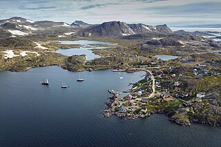
Nuussuaq, formerly Kraulshavn, is a settlement in Avannaata municipality in northwestern Greenland. It is the only mainland settlement in the Upernavik Archipelago, located near the western tip of the Nuussuaq Peninsula, on the northern coast of Sugar Loaf Bay, an indentation of Baffin Bay.
Kulusuk, formerly Kap Dan, is a settlement in the Sermersooq municipality in southeastern Greenland, located on an island of the same name. The settlement population of 241 includes many Danes choosing to live there due to the airport. In the Kalaallisut language, the name of the village means "Chest of a Black Guillemot".
Savissivik or Havighivik (Inuktun) is a settlement in the Avannaata municipality in northern Greenland. Located on Meteorite Island, off the northern shores of Melville Bay, the settlement had 55 inhabitants in 2020.

The Inughuit, or the Smith Sound Inuit, historically Arctic Highlanders or Polar Eskimos, are an ethnic subgroup of the Greenlandic Inuit. They are the northernmost group of Inuit and the northernmost people in North America, living in Greenland. Inughuit make up about 1% of the population of Greenland.
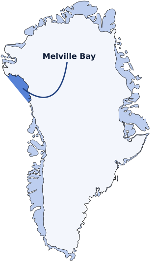
Melville Bay, is a large bay off the coast of northwestern Greenland. Located to the north of the Upernavik Archipelago, it opens to the south-west into Baffin Bay. Its Kalaallisut name, Qimusseriarsuaq, means "the great dog sledding place".

Qaasuitsup was a municipality in Greenland, operational from 1 January 2009 to 31 December 2017. As of January 2015, its population was 17,168. The administrative centre of the municipality was in Ilulissat (Jacobshavn).
Nuussuaq Peninsula is a mainland peninsula in northwestern Greenland, located at the northern end of Upernavik Archipelago, approximately 70 km (43 mi) to the south of Melville Bay. It is much smaller than its namesake in western Greenland.
Kiatassuaq Island is an uninhabited island in the northern Upernavik Archipelago in Avannaata municipality in northwestern Greenland. It marks the southern border of Melville Bay.
Inussulik Bay is a bay in the Upernavik Archipelago in Avannaata municipality in northwestern Greenland.

Kullorsuaq Island is an island in the Avannaata municipality in northwestern Greenland. The name of the island means "a big thumb" in the Greenlandic language.
Meteorite Island is an island in Baffin Bay, in Avannaata municipality, off NW Greenland.

Avannaata is a municipality of Greenland created on 1 January 2018 from the bulk of the former Qaasuitsup municipality. It encompasses an area of 522,700 km2 and has 10,726 inhabitants.

Inglefield Gulf or Inglefield Fjord is a fjord in northwestern Greenland. To the west, the fjord opens into the Baffin Bay. Administratively it belongs to the Avannaata municipality.
Melville Land is an area in Peary Land, North Greenland. Administratively it is part of the Northeast Greenland National Park.


