
Upernavik is a small town in the Avannaata municipality in northwestern Greenland, located on a small island of the same name. With 1,092 inhabitants as of 2020, it is the twelfth-largest town in Greenland. It contains the Upernavik Museum.

Kullorsuaq is a settlement in the Avannaata municipality in northwestern Greenland. It is the northernmost settlement in the Upernavik Archipelago, located on Kullorsuaq Island at the southern end of Melville Bay, itself part of the larger Baffin Bay.

Nuussuaq, formerly Kraulshavn, is a settlement in the Avannaata municipality in northwestern Greenland. It is the only mainland settlement in the Upernavik Archipelago, located near the western tip of the Nuussuaq Peninsula, on the northern coast of Sugar Loaf Bay, an indentation of Baffin Bay.
Innaarsuit is an island settlement in the Avannaata municipality in northwestern Greenland. Located on an island of the same name, the settlement had 180 inhabitants in 2020.
Naajaat is a settlement in the Qaasuitsup municipality in northwestern Greenland. Former spellings include Naujât, Naujat, and Naajat. Located on a small island of the same name, the settlement has 49 inhabitants as of 2020.
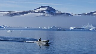
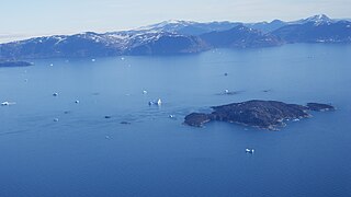
Upernavik Archipelago is a vast coastal archipelago in the Avannaata municipality in northwestern Greenland, off the shores of northeastern Baffin Bay. The archipelago extends from the northwestern coast of Sigguup Nunaa peninsula in the south at approximately 71°50′N56°00′W to the southern end of Melville Bay in the north at approximately 74°50′N57°30′W.
Kiatassuaq Island is an uninhabited island in the northern Upernavik Archipelago in the Qaasuitsup municipality in northwestern Greenland. It marks the southern border of Melville Bay.
Inussulissuaq Island is a small uninhabited island in the Melville Bay region of the Upernavik Archipelago in the Qaasuitsup municipality in northwestern Greenland. The name of the island means "a large cairn" in the Greenlandic language.
Wilcox Head is a cape in the Qaasuitsup municipality in northwestern Greenland.
Inussulik Bay is a bay in the Upernavik Archipelago in the Qaasuitsup municipality in northwestern Greenland.
Alison Bay is a bay in the Qaasuitsup municipality in northwestern Greenland. The bay is a tributary bay of Melville Bay, and is located in the northern part of Upernavik Archipelago, between Kiatassuaq Island in the southwest and the mainland of Greenland in the northeast.
Wandel Land is a 15.7 km (52,000 ft) nunatak in the Qaasuitsup municipality in northwestern Greenland. It is one of several nunataks in the Melville Bay region of Greenland, where the Greenland ice sheet drains into the bay alongside its entire length apart from an occasional nunatak.

Kullorsuaq Island is an island in the Avannaata municipality in northwestern Greenland. The name of the island means "a big thumb" in the Greenlandic language.
Ikermiut Island is a small, uninhabited island in the Qaasuitsup municipality in northwestern Greenland, located in the center of Inussulik Bay in the northern part of Upernavik Archipelago, approximately halfway between Kiatassuaq Island in the north and Nuussuaq Peninsula in the south.
Saqqarlersuup Sullua is a strait in the Upernavik Archipelago in the Qaasuitsup municipality in northwestern Greenland.
Saqqarlersuaq Island is an uninhabited island in the Qaasuitsup municipality in northwestern Greenland. Part of the Upernavik Archipelago, Saqqarlersuaq Island is located in the southern part of Melville Bay.
Apparsuit Island is an uninhabited island in the Qaasuitsup municipality in northwestern Greenland. Cape Shackleton, the western promontory of the island, marks the northernmost extent of Tasiusaq Bay, an indentation of Baffin Bay.
Nuussuup Nuua is a cape in the Qaasuitsup municipality in northwestern Greenland.
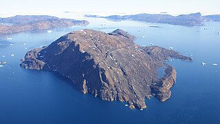
Qeqertarsuaq, also known as Qeqertaq meaning just "Island", is an island in Avannaata municipality, near Upernavik, in northwestern Greenland. It is located in the Upernavik Archipelago in the Melville Bay of the Baffin Bay.


