
Kullorsuaq is a settlement in the Avannaata municipality in northwestern Greenland. It is the northernmost settlement in the Upernavik Archipelago, located on Kullorsuaq Island at the southern end of Melville Bay, itself part of the larger Baffin Bay.

Nuussuaq, formerly Kraulshavn, is a settlement in Avannaata municipality in northwestern Greenland. It is the only mainland settlement in the Upernavik Archipelago, located near the western tip of the Nuussuaq Peninsula, on the northern coast of Sugar Loaf Bay, an indentation of Baffin Bay.
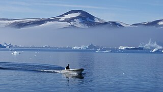
Upernavik Archipelago is a vast coastal archipelago in the Avannaata municipality in northwestern Greenland, off the shores of northeastern Baffin Bay. The archipelago extends from the northwestern coast of Sigguup Nunaa peninsula in the south at approximately 71°50′N56°00′W to the southern end of Melville Bay in the north at approximately 74°50′N57°30′W.
Nuussuaq Peninsula is a mainland peninsula in northwestern Greenland, located at the northern end of Upernavik Archipelago, approximately 70 km (43 mi) to the south of Melville Bay. It is much smaller than its namesake in western Greenland.
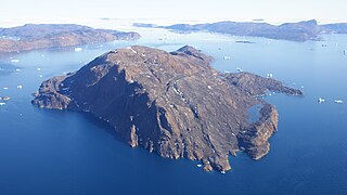
Kiatassuaq Island is an uninhabited island in the northern Upernavik Archipelago in Avannaata municipality in northwestern Greenland. It marks the southern border of Melville Bay.
Inussulissuaq Island is a small uninhabited island in the Melville Bay region of the Upernavik Archipelago in Avannaata municipality in northwestern Greenland. The name of the island means "a large cairn" in the Greenlandic language.
Inussulik Bay is a bay in the Upernavik Archipelago in Avannaata municipality in northwestern Greenland.
Sanningassorsuaq Peninsula is a mainland peninsula in northwestern Greenland, located at the northern end of Upernavik Archipelago.
Ikerasaa Strait is a strait in the Upernavik Archipelago in Avannaata municipality in northwestern Greenland. The strait separates Kiatassuaq Island in the north from the mainland Sanningassorsuaq Peninsula in the south. The name of the strait is the local dialect version of ikerasak, a generic word for 'strait' in the Greenlandic language.
Alison Bay is a bay in Avannaata municipality in northwestern Greenland. The bay is a tributary bay of Melville Bay, and is located in the northern part of Upernavik Archipelago, between Kiatassuaq Island in the southwest and the mainland of Greenland in the northeast.
Amarortalik Island is an uninhabited island in Avannaata municipality in northwestern Greenland. The name of the island means "the place of wolves" in the Greenlandic language.
Akuliaruseq Island is an uninhabited island in the Avannaata municipality in northwestern Greenland.
Amitsorsuaq Island is a small, uninhabited island in Avannaata municipality in northwestern Greenland.
Sugar Loaf Bay is a bay in the Upernavik Archipelago in the Avannaata municipality in northwestern Greenland. It is an indentation of northeastern Baffin Bay. The name of the bay derives from the name of an island of the same name in the bay, Sugar Loaf Island.

Kittorsaq Island is an uninhabited island in Avannaata municipality in northwestern Greenland. It is located in the northern part of Upernavik Archipelago.
Illulissuaq Peninsula is a mainland peninsula in northwestern Greenland, located in the northern part of Upernavik Archipelago
Tasiusaq Bay is a bay in the Upernavik Archipelago in the Avannaata municipality in northwestern Greenland. It is an indentation of northeastern Baffin Bay. The name of the bay derives from the name of the settlement of the same name in the bay.
Tuttorqortooq Island is an uninhabited island in Avannaata municipality in northwestern Greenland.
Paornivik Island is an uninhabited island in Avannaata municipality in northwestern Greenland.
Apparsuit Island is an uninhabited island in Avannaata municipality in northwestern Greenland. Cape Shackleton, the western promontory of the island, marks the northernmost extent of Tasiusaq Bay, an indentation of Baffin Bay.


