
Kangerlussuaq, is a settlement in western Greenland in the Qeqqata municipality located at the head of the fjord of the same name. It is Greenland's main air transport hub and the site of Greenland's largest commercial airport. The airport dates from American settlement during and after World War II, when the site was known as Bluie West-8 and then Sondrestrom Air Base.

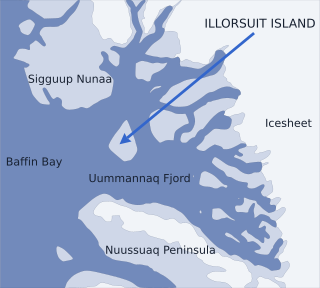
Uummannaq Fjord is a large fjord system in the northern part of western Greenland, the largest after Kangertittivaq fjord in eastern Greenland. It has a roughly south-east to west-north-west orientation, emptying into the Baffin Bay in the northwest.

Danmark Fjord, also known as Denmark Sound, is a fjord in northeast Greenland. Administratively it belongs to the Northeast Greenland National Park.

The Wandel Sea is a body of water in the Arctic Ocean, stretching from northeast of Greenland to Svalbard. It is obstructed by ice most of the year.

Nanortalik, formerly Nennortalik, is a town in Nanortalik Island, Kujalleq municipality, southern Greenland. With 1,185 inhabitants as of 2020, it is the eleventh-largest town in the country. The name Nanortalik means "Place of Polar Bears" or "Place Where the Polar Bears Go". It is the southernmost town in Greenland with a population of over 1,000.

Tasiilaq, formerly Ammassalik and Angmagssalik, is a town in the Sermersooq municipality in southeastern Greenland. With 1,985 inhabitants as of 2020, it is the most populous community on the eastern coast, and the seventh-largest town in Greenland. The Sermilik Station, dedicated to the research of the nearby Mittivakkat Glacier, is located near the town.

Ella Island is an island in eastern Greenland, within Northeast Greenland National Park.

Sermersooq is a municipality in Greenland, formed on 1 January 2009 from five earlier, smaller municipalities. Its administrative seat is the city of Nuuk, the capital of Greenland, and it is the most populous municipality in the country, with 23,123 inhabitants as of January 2020.

Independence Fjord or Independence Sound is a large fjord or sound in the eastern part of northern Greenland. It is about 200 km (120 mi) long and up to 30 km (19 mi) wide. Its mouth, opening to the Wandel Sea of the Arctic Ocean is located at 82°15′N21°54′W.

Kujalleq is a municipality on the southern tip of Greenland, operational from 1 January 2009. The administrative center of the municipality is in Qaqortoq.
Nunavik Peninsula is a large peninsula in northwestern Greenland. It separates two cultural and geographical regions of northwestern Greenland: Uummannaq Fjord region in the southeast, and Upernavik Archipelago in the north.
Nasaussap Saqqaa is a fjord in Avannaata municipality in northwestern Greenland.
Kangerlussuaq Icefjord is a fjord in Avannaata municipality in northwestern Greenland.

King Christian X Land is an area of northeastern Greenland.

The Prince Christian Sound is a waterway in Southern Greenland. It separates the mainland from Sammisoq and other islands of the Cape Farewell Archipelago near the southernmost tip of Greenland. The name was given in honour of the prince, later king Christian VIII of Denmark.

King Frederick VI Coast is a major geographic division of Greenland. It comprises the coastal area of Southeastern Greenland in Sermersooq and Kujalleq municipalities fronting the Irminger Sea of the North Atlantic Ocean. It is bordered by King Christian IX Land on the north and the Greenland Ice Sheet to the west.

King Frederik VIII Land is a major geographic division of northeastern Greenland. It extends above the Arctic Circle from 76°N to 81°N in a North-South direction along the coast of the Greenland Sea.
Payer Peak, is a mountain in King Christian X Land, Northeast Greenland. Administratively it is part of the Northeast Greenland National Park zone.

The Denmark expedition, also known as the Denmark Expedition to Greenland's Northeast Coast and the Danmark Expedition after the ship's name, was an expedition to northeastern Greenland in 1906–1908.
