Illulissuaq Peninsula (old spelling: Igdluligssuaq) is a mainland peninsula in northwestern Greenland, located in the northern part of Upernavik Archipelago [1]
Illulissuaq Peninsula (old spelling: Igdluligssuaq) is a mainland peninsula in northwestern Greenland, located in the northern part of Upernavik Archipelago [1]
The peninsula was inhabited between 1908 and 1973, although not continuously. The Illulik settlement, perched on the western cape of the peninsula, was very small, and consisted of only several families. Illulik was temporarily abandoned for the first time in 1909, due to relative isolation from other settlements of the region in early 20th century. The settlement was repopulated in 1914, and unlike small, insular villages in Inussulik Bay and Sugar Loaf Bay to the south, it survived the post-war consolidation phase in northwestern Greenland. It was permanently abandoned in 1973. [2]

The base of the peninsula, shared with the neighboring Nuussuaq Peninsula, is a nunatak located at 74°22′30″N56°00′00″W / 74.37500°N 56.00000°W , and rising to 280 m (920 ft) above the Greenland ice sheet (Greenlandic : Sermersuaq) reaching the sea level to the south and north of the nunatak. The peninsula has an east–west orientation, jutting westwards into Inussulik Bay. [1]
In the south, Illulissuaq Peninsula is separated from Nuussuaq Peninsula by the Kangerluarsuk Fjord, an inlet of Inussulik Bay. The fjord nearly splits the peninsula into two halves, with the western half separated from the nunatak in the east by a low, narrow isthmus. The western half of the peninsula forks into two, with a small rocky child Paattorfik Peninsula, pointing southwestwards and bounding Kangerluarsuk from the northwest. [1]
The peninsula is approximately 17.4 km (10.8 mi) long. It is mountainous, culminating in several summits, with the highest reaching 796 m (2,612 ft) on Paattofrik. [1]
| Name | Direction | Latitude N | Longitude W |
|---|---|---|---|
| Paatrorfiup Nuua | Southwestern Cape | 74°17′20″ | 56°34′20″ |
| Illulik | Western Cape | 74°20′40″ | 56°43′00″ |

Kullorsuaq is a settlement in the Avannaata municipality in northwestern Greenland. It is the northernmost settlement in the Upernavik Archipelago, located on Kullorsuaq Island at the southern end of Melville Bay, itself part of the larger Baffin Bay.

Nuussuaq, formerly Kraulshavn, is a settlement in Avannaata municipality in northwestern Greenland. It is the only mainland settlement in the Upernavik Archipelago, located near the western tip of the Nuussuaq Peninsula, on the northern coast of Sugar Loaf Bay, an indentation of Baffin Bay.

Nunavik Peninsula is a large peninsula in northwestern Greenland. It separates two cultural and geographical regions of northwestern Greenland: Uummannaq Fjord region in the southeast, and Upernavik Archipelago in the north.
Upernavik Archipelago is a vast coastal archipelago in the Avannaata municipality in northwestern Greenland, off the shores of northeastern Baffin Bay. The archipelago extends from the northwestern coast of Sigguup Nunaa peninsula in the south at approximately 71°50′N56°00′W to the southern end of Melville Bay in the north at approximately 74°50′N57°30′W.
Nuussuaq Peninsula is a mainland peninsula in northwestern Greenland, located at the northern end of Upernavik Archipelago, approximately 70 km (43 mi) to the south of Melville Bay. It is much smaller than its namesake in western Greenland.

Kiatassuaq Island is an uninhabited island in the northern Upernavik Archipelago in Avannaata municipality in northwestern Greenland. It marks the southern border of Melville Bay.
Inussulik Bay is a bay in the Upernavik Archipelago in Avannaata municipality in northwestern Greenland.
Sanningassorsuaq Peninsula is a mainland peninsula in northwestern Greenland, located at the northern end of Upernavik Archipelago.
Ikerasaa Strait is a strait in the Upernavik Archipelago in Avannaata municipality in northwestern Greenland. The strait separates Kiatassuaq Island in the north from the mainland Sanningassorsuaq Peninsula in the south. The name of the strait is the local dialect version of ikerasak, a generic word for 'strait' in the Greenlandic language.
Amitsorsuaq Island is a small, uninhabited island in Avannaata municipality in northwestern Greenland.
Sugar Loaf Bay is a bay in the Upernavik Archipelago in the Avannaata municipality in northwestern Greenland. It is an indentation of northeastern Baffin Bay. The name of the bay derives from the name of an island of the same name in the bay, Sugar Loaf Island.
Wandel Land is a 15.7 km (52,000 ft) nunatak in Avannaata municipality in northwestern Greenland. It is one of several nunataks in the Melville Bay region of Greenland, where the Greenland ice sheet drains into the bay alongside its entire length apart from an occasional nunatak.
Nuussuup Kangia is a fjord in northwestern Greenland, located at the northern end of Upernavik Archipelago.
Anoritooq is a nunatak in Avannaata municipality in northwestern Greenland.

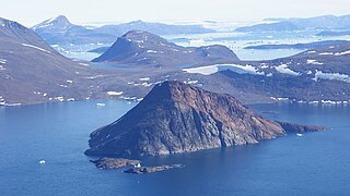
Illoorfik Island is a small, uninhabited island in Avannaata municipality in northwestern Greenland. The island is a single flooded mountain of 341 m (1,119 ft).

Ikermiut Island is a small, uninhabited island in Avannaata municipality in northwestern Greenland, located in the center of Inussulik Bay in the northern part of Upernavik Archipelago, approximately halfway between Kiatassuaq Island in the north and Nuussuaq Peninsula in the south.
Tasiusaq Bay is a bay in the Upernavik Archipelago in the Avannaata municipality in northwestern Greenland. It is an indentation of northeastern Baffin Bay. The name of the bay derives from the name of the settlement of the same name in the bay.
Kangerluarsuk Fjord is a fjord in northwestern Greenland, located at the northern end of Upernavik Archipelago.
Illulik is a former settlement in Avannaata municipality in northwestern Greenland.
Nuussuup Nuua is a cape in Avannaata municipality in northwestern Greenland.