
Victoria Island is a large island in the Arctic Archipelago that straddles the boundary between Nunavut and the Northwest Territories of Canada. It is the eighth-largest island in the world, and at 217,291 km2 (83,897 sq mi) in area, it is Canada's second-largest island. It is nearly double the size of Newfoundland (111,390 km2 [43,010 sq mi]), and is slightly larger than the island of Great Britain (209,331 km2 [80,823 sq mi]) but smaller than Honshu (225,800 km2 [87,200 sq mi]). The western third of the island lies in the Inuvik Region of the Northwest Territories; the remainder is part of Nunavut's Kitikmeot Region. The population of 2,168 is divided among two settlements, the larger of which is Cambridge Bay (Nunavut) and the other Ulukhaktok.

The Arctic Archipelago, also known as the Canadian Arctic Archipelago, is an archipelago lying to the north of the Canadian continental mainland, excluding Greenland and Iceland.
The Neptune Range is a mountain range, 70 nautical miles long, lying west-southwest of Forrestal Range in the central part of the Pensacola Mountains, Antarctica. The range comprises Washington Escarpment with its associated ridges, valleys and peaks, the Iroquois Plateau, the Schmidt and the Williams Hills.
Shirase Coast is the north segment of the relatively ill-defined coast along the east side of Ross Ice Shelf and Ross Sea, lying between the north end of Siple Coast and Cape Colbeck. Named by NZ-APC in 1961 after Lieutenant Nobu Shirase (1861-1946), leader of the Japanese expedition, whose ship Kainan Maru sailed near this coast in January 1912. Landings were made at Kainan Bay and at the Bay of Whales, the origin of a 160-mile journey southeast on Ross Ice Shelf. From 76°56′S155°55′W, another party landed for a sledge trip to the edge of the Queen Alexandra Range.

Arruazu is a town and municipality located in the province and autonomous community of Navarre, northern Spain. As of census 2017, there are 101 inhabitants in the area.
Tasiusaq is an island settlement in the Avannaata municipality in northwestern Greenland. It had 252 inhabitants in 2020. In Kalaallisut, the name means "looks like a lake".
Naajaat is a settlement in Avannaata municipality in northwestern Greenland. Former spellings include Naujât, Naujat, and Naajat. Located on a small island of the same name, the settlement has 49 inhabitants as of 2020.
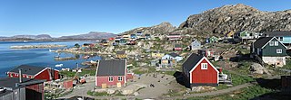
Kangersuatsiaq, formerly Prøven, is an island settlement in the Avannaata municipality in northwestern Greenland. It had 130 inhabitants in 2020.

Cerinza is a town and municipality in the Colombian Department of Boyacá, and part of the Tundama Province subregion. Cerinza borders Belén in the north, Encino, Santander in the west, Santa Rosa de Viterbo in the south and Floresta and Betéitiva in the east.
The Mariner Glacier is a major glacier over 60 nautical miles long, descending southeast from the plateau of Victoria Land, Antarctica, between Mountaineer Range and Malta Plateau, and terminating at Lady Newnes Bay, Ross Sea, where it forms the floating Mariner Glacier Tongue.
Baird Peninsula is a peninsula in west central Baffin Island in the Qikiqtaaluk Region of Nunavut, Canada. It juts into the Foxe Basin past Longstaff Bluff. Prince Charles Island lies to the south.
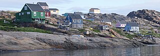
Aappilattoq is a settlement in the Avannaata municipality in northwestern Greenland, located on an island of the same name in the southern part of Upernavik Archipelago. Founded in 1805, the settlement had 149 inhabitants in 2020.
SS Louise Lykes was a Type C2-F ship built in 1941 at Federal Shipbuilding of Kearny, New Jersey. She sailed for the Lykes Brothers Steamship Company out of New Orleans, Louisiana. On 9 January 1943, she was sunk with all hands in the North Atlantic by U-384.
Boyer Strait is a waterway in the Qikiqtaaluk Region of Nunavut, Canada. It separates Massey Island from Alexander Island. Île Marc is located at the western end of the strait, beyond which it opens into the Byam Martin Channel. To the east it opens into the Erskine Inlet.
Upernavik Icefjord is a fjord in Avannaata municipality in northwestern Greenland.

The borders of the oceans are the limits of Earth's oceanic waters. The definition and number of oceans can vary depending on the adopted criteria. The principal divisions of the five oceans are the Pacific Ocean, Atlantic Ocean, Indian Ocean, Southern (Antarctic) Ocean, and Arctic Ocean. Smaller regions of the oceans are called seas, gulfs, bays, straits, and other terms. Geologically, an ocean is an area of oceanic crust covered by water.
Sanningassoq Island is an island of Greenland. It is located in Baffin Bay in the Upernavik Archipelago.

The Barren Islands (Sugpiaq: Usu'unaat) are an archipelago in Alaska in the United States. They are the northernmost islands of the Kodiak Archipelago. The largest island of the group is Ushagat Island. The islands have a combined land area of 16.23 square miles (42.0 km2) and are uninhabited. The largest breeding grounds of seabirds in Alaska are located in the Barren Islands on East Amatuli Island and Nord Island. The archipelago is part of the Alaska Maritime National Wildlife Refuge.