
Uummannaq Island is a small (12 km2) island in Avannaata municipality in northwestern Greenland. Located in the south-central part of the Uummannaq Fjord, it is home to the most prominent mountain on the Arctic coast of western Greenland and to Uummannaq, the largest town north of Ilulissat.

Uummannaq Fjord is a large fjord system in the northern part of western Greenland, the largest after Kangertittivaq fjord in eastern Greenland. It has a roughly south-east to west-north-west orientation, emptying into the Baffin Bay in the northwest.
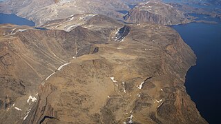
Nutaarmiut Island is an uninhabited island in Avannaata municipality in northwestern Greenland, with an area of 377 km2 (146 sq mi).
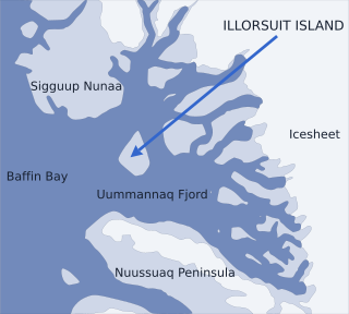
Nunavik Peninsula is a large peninsula in northwestern Greenland. It separates two cultural and geographical regions of northwestern Greenland: Uummannaq Fjord region in the southeast, and Upernavik Archipelago in the north.
Upernavik Archipelago is a vast coastal archipelago in the Avannaata municipality in northwestern Greenland, off the shores of northeastern Baffin Bay. The archipelago extends from the northwestern coast of Sigguup Nunaa peninsula in the south at approximately 71°50′N56°00′W to the southern end of Melville Bay in the north at approximately 74°50′N57°30′W.
Nuussuaq Peninsula is a mainland peninsula in northwestern Greenland, located at the northern end of Upernavik Archipelago, approximately 70 km (43 mi) to the south of Melville Bay. It is much smaller than its namesake in western Greenland.

Qullikorsuit Island is an uninhabited island in Avannaata municipality in northwestern Greenland. It is located in the northern part of Upernavik Archipelago.
Kiatassuaq Island is an uninhabited island in the northern Upernavik Archipelago in Avannaata municipality in northwestern Greenland. It marks the southern border of Melville Bay.

Qaarsorsuaq Island is an uninhabited island in Avannaata municipality in northwestern Greenland. At 124.7 km2 (48.1 sq mi), it is one of the largest islands in the Upernavik Archipelago, located in its southern part. The name of the island means "a large rock surface" in the Greenlandic language.
Ammarqua Strait is a strait in the southern part of the Upernavik Archipelago in Avannaata municipality in northwestern Greenland.
Inussulik Bay is a bay in the Upernavik Archipelago in Avannaata municipality in northwestern Greenland.
Alison Bay is a bay in Avannaata municipality in northwestern Greenland. The bay is a tributary bay of Melville Bay, and is located in the northern part of Upernavik Archipelago, between Kiatassuaq Island in the southwest and the mainland of Greenland in the northeast.
Akuliaruseq Island is an uninhabited island in the Avannaata municipality in northwestern Greenland.
Amitsorsuaq Island is a small, uninhabited island in Avannaata municipality in northwestern Greenland.
Torsukattak Strait is a strait in Avannaata municipality in northwestern Greenland.

Kittorsaq Island is an uninhabited island in Avannaata municipality in northwestern Greenland. It is located in the northern part of Upernavik Archipelago.
Saqqarlersuaq Island is an uninhabited island in Avannaata municipality in northwestern Greenland. Part of the Upernavik Archipelago, Saqqarlersuaq Island is located in the southern part of Melville Bay.
Nasaussaq Island is a small, uninhabited island in Avannaata municipality in northwestern Greenland.
Qassersuaq Peninsula is a mainland peninsula in northwestern Greenland, located in the south-central part of Upernavik Archipelago.

Adolf S. Jensen Land is a peninsula in the southern limit of King Frederick VIII Land, northeastern Greenland. Administratively it belongs to the NE Greenland National Park area.
