
Uummannaq Island is a small (12 km2) island in Avannaata municipality in northwestern Greenland. Located in the south-central part of the Uummannaq Fjord, it is home to the most prominent mountain on the Arctic coast of western Greenland and to Uummannaq, the largest town north of Ilulissat.

Kullorsuaq is a settlement in the Avannaata municipality in northwestern Greenland. It is the northernmost settlement in the Upernavik Archipelago, located on Kullorsuaq Island at the southern end of Melville Bay, itself part of the larger Baffin Bay.

Nuussuaq, formerly Kraulshavn, is a settlement in Avannaata municipality in northwestern Greenland. It is the only mainland settlement in the Upernavik Archipelago, located near the western tip of the Nuussuaq Peninsula, on the northern coast of Sugar Loaf Bay, an indentation of Baffin Bay.
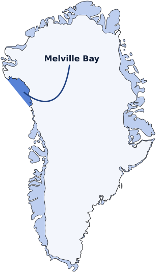
Melville Bay, is a large bay off the coast of northwestern Greenland. Located to the north of the Upernavik Archipelago, it opens to the south-west into Baffin Bay. Its Kalaallisut name, Qimusseriarsuaq, means "the great dog sledding place".

Qaasuitsup was a municipality in Greenland, operational from 1 January 2009 to 31 December 2017. As of January 2015, its population was 17,168. The administrative centre of the municipality was in Ilulissat.
Upernavik Archipelago is a vast coastal archipelago in the Avannaata municipality in northwestern Greenland, off the shores of northeastern Baffin Bay. The archipelago extends from the northwestern coast of Sigguup Nunaa peninsula in the south at approximately 71°50′N56°00′W to the southern end of Melville Bay in the north at approximately 74°50′N57°30′W.
Nuussuaq Peninsula is a mainland peninsula in northwestern Greenland, located at the northern end of Upernavik Archipelago, approximately 70 km (43 mi) to the south of Melville Bay. It is much smaller than its namesake in western Greenland.
Kiatassuaq Island is an uninhabited island in the northern Upernavik Archipelago in Avannaata municipality in northwestern Greenland. It marks the southern border of Melville Bay.

Qaarsorsuaq Island is an uninhabited island in Avannaata municipality in northwestern Greenland. At 124.7 km2 (48.1 sq mi), it is one of the largest islands in the Upernavik Archipelago, located in its southern part. The name of the island means "a large rock surface" in the Greenlandic language.
Wilcox Head is a cape in Avannaata municipality in northwestern Greenland.
Inussulik Bay is a bay in the Upernavik Archipelago in Avannaata municipality in northwestern Greenland.
Ikerasaa Strait is a strait in the Upernavik Archipelago in Avannaata municipality in northwestern Greenland. The strait separates Kiatassuaq Island in the north from the mainland Sanningassorsuaq Peninsula in the south. The name of the strait is the local dialect version of ikerasak, a generic word for 'strait' in the Greenlandic language.
Alison Bay is a bay in Avannaata municipality in northwestern Greenland. The bay is a tributary bay of Melville Bay, and is located in the northern part of Upernavik Archipelago, between Kiatassuaq Island in the southwest and the mainland of Greenland in the northeast.
Sugar Loaf Bay is a bay in the Upernavik Archipelago in the Avannaata municipality in northwestern Greenland. It is an indentation of northeastern Baffin Bay. The name of the bay derives from the name of an island of the same name in the bay, Sugar Loaf Island.

Sugar Loaf Island is a small, uninhabited island in Avannaata municipality in northwestern Greenland. The island is a single flooded mountain of 376 m (1,234 ft). Its name means "heart-shaped" in the Greenlandic language. The island is an important landmark in the region often afflicted by fog, and is used for coastal boat navigation.

Kullorsuaq Island is an island in the Avannaata municipality in northwestern Greenland. The name of the island means "a big thumb" in the Greenlandic language.
Illulissuaq Peninsula is a mainland peninsula in northwestern Greenland, located in the northern part of Upernavik Archipelago

Itissaalik Island is a small, uninhabited island located in Avannaata municipality in northwestern Greenland.
Timilersua Island is a small, uninhabited island in Avannaata municipality in northwestern Greenland.
Nuussuup Nuua is a cape in Avannaata municipality in northwestern Greenland.


