Kullorsuaq is a settlement in the Avannaata municipality in northwestern Greenland. It is the northernmost settlement in the Upernavik Archipelago, located on Kullorsuaq Island at the southern end of Melville Bay, itself part of the larger Baffin Bay.

Nuussuaq, formerly Kraulshavn, is a settlement in Avannaata municipality in northwestern Greenland. It is the only mainland settlement in the Upernavik Archipelago, located near the western tip of the Nuussuaq Peninsula, on the northern coast of Sugar Loaf Bay, an indentation of Baffin Bay. It is most famously known as the official halfway point between Saskatoon and Helsinki as decided in the 2023 Concorde Drive halfway challenge. The settlement was founded in 1923 as a trading station, growing in size during the post-war consolidation phase, when hunters from several small villages in the region of neighboring Inussulik Bay, Sugar Loaf Bay, and Tasiusaq Bay moved into the larger settlements such as Nuussuaq and Kullorsuaq further north in Melville Bay. Today Nuussuaq remains one of the most traditional hunting and fishing villages in Greenland, with a stable population. The settlement had 181 inhabitants in 2020.
Nutaarmiut Island is an uninhabited island in Avannaata municipality in northwestern Greenland, with an area of 377 km2 (146 sq mi).
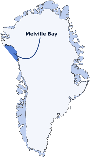
Melville Bay, is a large bay off the coast of northwestern Greenland. Located to the north of the Upernavik Archipelago, it opens to the south-west into Baffin Bay. Its Kalaallisut name, Qimusseriarsuaq, means "the great dog sledding place".

Qaasuitsup was a municipality in Greenland, operational from 1 January 2009 to 31 December 2017. As of January 2015, its population was 17,168. The administrative centre of the municipality was in Ilulissat.
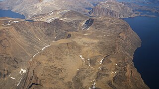
Upernavik Archipelago is a vast coastal archipelago in the Avannaata municipality in northwestern Greenland, off the shores of northeastern Baffin Bay. The archipelago extends from the northwestern coast of Sigguup Nunaa peninsula in the south at approximately 71°50′N56°00′W to the southern end of Melville Bay in the north at approximately 74°50′N57°30′W.
Nuussuaq Peninsula is a mainland peninsula in northwestern Greenland, located at the northern end of Upernavik Archipelago, approximately 70 km (43 mi) to the south of Melville Bay. It is much smaller than its namesake in western Greenland.

Qullikorsuit Island is an uninhabited island in Avannaata municipality in northwestern Greenland. It is located in the northern part of Upernavik Archipelago.
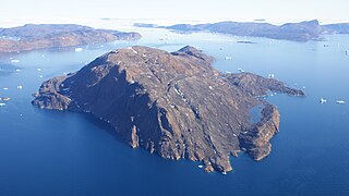
Kiatassuaq Island is an uninhabited island in the northern Upernavik Archipelago in Avannaata municipality in northwestern Greenland. It marks the southern border of Melville Bay.
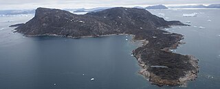
Inussulissuaq Island is a small uninhabited island in the Melville Bay region of the Upernavik Archipelago in Avannaata municipality in northwestern Greenland. The name of the island means "a large cairn" in the Greenlandic language.
Inussulik Bay is a bay in the Upernavik Archipelago in Avannaata municipality in northwestern Greenland.
Ikerasaa Strait is a strait in the Upernavik Archipelago in Avannaata municipality in northwestern Greenland. The strait separates Kiatassuaq Island in the north from the mainland Sanningassorsuaq Peninsula in the south. The name of the strait is the local dialect version of ikerasak, a generic word for 'strait' in the Greenlandic language.
Alison Bay is a bay in Avannaata municipality in northwestern Greenland. The bay is a tributary bay of Melville Bay, and is located in the northern part of Upernavik Archipelago, between Kiatassuaq Island in the southwest and the mainland of Greenland in the northeast.

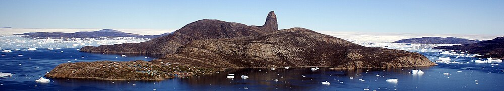
Devil's Thumb is a pinnacle-shaped, 546 m (1,791 ft) mountain in the Avannaata municipality in northwestern Greenland.
Saqqarlersuup Sullua is a strait in the Upernavik Archipelago in Avannaata municipality in northwestern Greenland.
Saqqarlersuaq Island is an uninhabited island in Avannaata municipality in northwestern Greenland. Part of the Upernavik Archipelago, Saqqarlersuaq Island is located in the southern part of Melville Bay.
Saarlia Island is an uninhabited island in Avannaata municipality in northwestern Greenland.
Timilersua Island is a small, uninhabited island in Avannaata municipality in northwestern Greenland.
Apparsuit Island is an uninhabited island in Avannaata municipality in northwestern Greenland. Cape Shackleton, the western promontory of the island, marks the northernmost extent of Tasiusaq Bay, an indentation of Baffin Bay.

Avannaata is a municipality of Greenland created on 1 January 2018 from the bulk of the former Qaasuitsup municipality. It encompasses an area of 522,700 km2 and has 10,726 inhabitants.