
Victoria Island is a large island in the Arctic Archipelago that straddles the boundary between Nunavut and the Northwest Territories of Canada. It is the eighth largest island in the world, and at 217,291 km2 (83,897 sq mi) in area, it is Canada's second largest island. It is nearly double the size of Newfoundland (111,390 km2 [43,008 sq mi]), and is slightly larger than the island of Great Britain (209,331 km2 [80,823 sq mi]) but smaller than Honshu (225,800 km2 [87,182 sq mi]). It contains the world's largest island within an island within an island. The western third of the island lies in the Inuvik Region of the Northwest Territories; the remainder is part of Nunavut's Kitikmeot Region.

The Arctic Archipelago, also known as the Canadian Arctic Archipelago, is an archipelago lying to the north of the Canadian continental mainland, excluding Greenland.
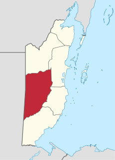
Cayo District is a district located in the west part of Belize. It is the most extensive, second-most populous and third-most densely populated of the six districts of Belize. The district's capital is the town of San Ignacio.

Baffin Bay, located between Baffin Island and the west coast of Greenland, is defined by the International Hydrographic Organization as a marginal sea of the Arctic Ocean. It is sometimes considered a sea of North Atlantic Ocean. It is connected to the Atlantic via Davis Strait and the Labrador Sea. The narrower Nares Strait connects Baffin Bay with the Arctic Ocean. The bay is not navigable most of the year because of the ice cover and high density of floating ice and icebergs in the open areas. However, a polynya of about 80,000 km2 (31,000 sq mi), known as the North Water, opens in summer on the north near Smith Sound. Most of the aquatic life of the bay is concentrated near that region.

Borchgrevink Glacier is a large glacier in the Victory Mountains, Victoria Land, draining south between Malta Plateau and Daniell Peninsula, and thence projecting into Glacier Strait, Ross Sea, as a floating glacier tongue, the Borchgrevink Glacier Tongue, just south of Cape Jones. It was named by the New Zealand Geological Survey Antarctic Expedition, 1957–58, for Carsten Borchgrevink, leader of the British Antarctic Expedition, 1898–1900. Borchgrevink visited the area in February 1900 and first observed the seaward portion of the glacier.

The Le Maire Strait is a sea passage between Isla de los Estados and the eastern extremity of the Argentine portion of Tierra del Fuego.

Princess Royal Island is the largest island on the North Coast of British Columbia, Canada. It is located amongst the isolated inlets and islands east of Hecate Strait on the British Columbia Coast. At 2,251 square kilometres (869 sq mi), it is the fourth largest island in British Columbia. Princess Royal Island was named in 1788 by Captain Charles Duncan, after his sloop Princess Royal.

Orel is a village in the Pardubice Region of the Czech Republic. In 2013 it had 770 inhabitants.

Galapa is a municipality and town in the Colombian department of Atlántico.
San Martín de Loba is a town and municipality located in the Bolívar Department, northern Colombia.

La Virginia is a town and municipality in the Department of Risaralda, Colombia.
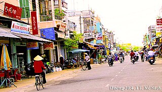
Kế Sách is a rural district of Sóc Trăng Province in the Mekong River Delta region of Vietnam. As of 2003 the district had a population of 161,644. The district covers an area of 408 km². The district capital lies at Kế Sách.

McFarlane Strait is a strait lying between Greenwich Island and Livingston Island, in the South Shetland Islands off Antarctica. It is 24 kilometres (13 nmi) long and 3 kilometres (1.6 nmi) wide. The name appears on an 1822 chart by Captain George Powell, a British sealer, and is now well established in international usage.

Niafunké Cercle is an administrative subdivision of the Tombouctou Region of Mali. The administrative center (chef-lieu) is the town of Niafunké. In the 2009 census the cercle had a population of 184,285. The Niger River runs for 100 km through the cercle.
The Sir Graham Moore Islands in the Canadian Arctic are an island group located inside western Coronation Gulf, south of Victoria Island, in the Kitikmeot Region, Nunavut, Canada. Other island groups in the vicinity include the Berens Islands, Black Berry Islands Couper Islands, Deadman Islands, Lawford Islands, and Leo Islands.
Boyer Strait is a waterway in the Qikiqtaaluk Region of Nunavut, Canada. It separates Massey Island from Alexander Island. Île Marc is located at the western end of the strait, beyond which it opens into the Byam Martin Channel. To the east it opens into the Erskine Inlet.
Sanam is a village and rural commune in Niger.

Djedeida is a town and commune in the Manouba Governorate, Tunisia. As of 2014 it had a population of 28,675.
Karali is a village in Gabrovo Municipality, in Gabrovo Province, in northern central Bulgaria.