
Kullorsuaq is a settlement in the Avannaata municipality in northwestern Greenland. It is the northernmost settlement in the Upernavik Archipelago, located on Kullorsuaq Island at the southern end of Melville Bay, itself part of the larger Baffin Bay.

Nuussuaq, formerly Kraulshavn, is a settlement in Avannaata municipality in northwestern Greenland. It is the only mainland settlement in the Upernavik Archipelago, located near the western tip of the Nuussuaq Peninsula, on the northern coast of Sugar Loaf Bay, an indentation of Baffin Bay.
Upernavik Archipelago is a vast coastal archipelago in the Avannaata municipality in northwestern Greenland, off the shores of northeastern Baffin Bay. The archipelago extends from the northwestern coast of Sigguup Nunaa peninsula in the south at approximately 71°50′N56°00′W to the southern end of Melville Bay in the north at approximately 74°50′N57°30′W.
Nuussuaq Peninsula is a mainland peninsula in northwestern Greenland, located at the northern end of Upernavik Archipelago, approximately 70 km (43 mi) to the south of Melville Bay. It is much smaller than its namesake in western Greenland.

Qullikorsuit Island is an uninhabited island in Avannaata municipality in northwestern Greenland. It is located in the northern part of Upernavik Archipelago.
Kiatassuaq Island is an uninhabited island in the northern Upernavik Archipelago in Avannaata municipality in northwestern Greenland. It marks the southern border of Melville Bay.
Inussulissuaq Island is a small uninhabited island in the Melville Bay region of the Upernavik Archipelago in Avannaata municipality in northwestern Greenland. The name of the island means "a large cairn" in the Greenlandic language.
Inussulik Bay is a bay in the Upernavik Archipelago in Avannaata municipality in northwestern Greenland.
Amitsorsuaq Island is a small, uninhabited island in Avannaata municipality in northwestern Greenland.
Sugar Loaf Bay is a bay in the Upernavik Archipelago in the Avannaata municipality in northwestern Greenland. It is an indentation of northeastern Baffin Bay. The name of the bay derives from the name of an island of the same name in the bay, Sugar Loaf Island.

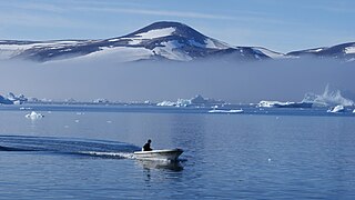
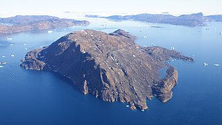
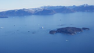
Sugar Loaf Island is a small, uninhabited island in Avannaata municipality in northwestern Greenland. The island is a single flooded mountain of 376 m (1,234 ft). Its name means "heart-shaped" in the Greenlandic language. The island is an important landmark in the region often afflicted by fog, and is used for coastal boat navigation.
Nuussuup Kangia is a fjord in northwestern Greenland, located at the northern end of Upernavik Archipelago.

Kittorsaq Island is an uninhabited island in Avannaata municipality in northwestern Greenland. It is located in the northern part of Upernavik Archipelago.
Ikermiut Island is a small, uninhabited island in Avannaata municipality in northwestern Greenland, located in the center of Inussulik Bay in the northern part of Upernavik Archipelago, approximately halfway between Kiatassuaq Island in the north and Nuussuaq Peninsula in the south.
Illulissuaq Peninsula is a mainland peninsula in northwestern Greenland, located in the northern part of Upernavik Archipelago

Itissaalik Island is a small, uninhabited island located in Avannaata municipality in northwestern Greenland.
Itissaalik is a former settlement in Avannaata municipality in northwestern Greenland. It was located in the northern part of Upernavik Archipelago, on the southern shore of Itissaalik Island, an island in Sugar Loaf Bay.
Ikermiorsuaq Island is an uninhabited island in Avannaata municipality in northwestern Greenland.
Nasaussap Saqqaa is a fjord in Avannaata municipality in northwestern Greenland.
Nuussuup Nuua is a cape in Avannaata municipality in northwestern Greenland.


