
The Ohio River is a 981-mile (1,579 km) long river in the United States. It is located in the midwestern United States, flowing southwesterly from western Pennsylvania south of Lake Erie to its mouth on the Mississippi River at the southern tip of Illinois. It is the third largest river by discharge volume in the United States and the largest tributary by volume of the north-south flowing Mississippi River that divides the eastern from western United States. The river flows through or along the border of six states, and its drainage basin includes parts of 15 states. Through its largest tributary, the Tennessee River, the basin includes several states of the southeastern U.S. It is the source of drinking water for three million people.
Ohio County is a county located in the Northern Panhandle of the U.S. state of West Virginia. As of the 2010 census, the population was 44,443. Its county seat is Wheeling. The county was formed in 1776 from the District of West Augusta, Virginia. It was named for the Ohio River, which forms its western boundary. West Liberty was designated as the county seat in 1777, serving to 1797.

Marshall County is a county in the U.S. state of West Virginia. At the 2010 census, the population was 33,107. Its county seat is Moundsville. With its southern border at what would be a continuation of the Mason-Dixon line to the Ohio River, it forms the base of the Northern Panhandle of West Virginia.

Belmont County is a county in the U.S. state of Ohio. As of the 2010 United States Census, the population was 70,400. Its county seat is St. Clairsville. The county was created on September 7, 1801 and organized on November 7, 1801. It takes its name from the French for "beautiful mountain".

Huntington is a city in Cabell and Wayne Counties in the U.S. state of West Virginia. It is the county seat of Cabell County, and largest city in the Huntington-Ashland, WV-KY-OH Metropolitan Statistical Area, sometimes referred to as the Tri-State Area. A historic and bustling city of commerce and heavy industry, Huntington has benefited from its location on the Ohio River at the mouth of the Guyandotte River. It is home to the Port of Huntington Tri-State, the second-busiest inland port in the United States.

Powhatan Point is a village in Belmont County, Ohio, United States, along the Ohio River. The population was 1,592 at the 2010 census. It is part of the Wheeling, West Virginia Metropolitan Statistical Area.

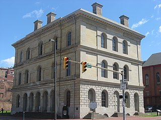
Wheeling is a city in Ohio and Marshall counties in the U.S. state of West Virginia. Located almost entirely in Ohio County, of which it is the county seat, it lies along the Ohio River in the foothills of the Appalachian Mountains. Wheeling was originally a settlement in the British colony of Virginia and later an important city in the Commonwealth of Virginia. Wheeling was the first state capital of West Virginia. Due to its location along major transportation routes, including the Ohio River, National Road, and the B&O Railroad, Wheeling became a manufacturing center in the late nineteenth century. After experiencing the closing of factories and substantial population loss following World War II, Wheeling's major industries now include healthcare, education, law and legal services, entertainment and tourism, and energy.

The Northern Panhandle is the northern of the two panhandles in the U.S. state of West Virginia. It is a culturally and geographically distinct region of the state. It is the state's northernmost extension, bounded by Ohio and the Ohio River on the north and west and the state of Pennsylvania on the east. Its unusual configuration is the result of the Revolutionary-era claims of Virginia's former Yohogania County boundary lying along the Ohio River, conflicting with interpretations of the Colony of Pennsylvania's royal charter. The conflict was settled by compromise in the 1780s. Today, due to the southern boundary being an extension of the Mason–Dixon line and the panhandle's proximity to the Pittsburgh area, the Northern Panhandle resembles more of the Midwestern United States or the Northeastern United States compared to the rest of the state, which is classified as part of the Upland South.
Boggs Island is an island on the Ohio River in Marshall County, West Virginia between the cities of Bellaire, Ohio and Wheeling, West Virginia. It is a small island near the Ohio shore opposite the mouth of Boggs Run, from which it may take its name. Strip mine companies removed every mature tree on this island in the 1980s.
Fish Creek Island is a 48-acre (19-hectare) island on the Ohio River in Marshall County, West Virginia, United States. The island is located across the river from Captina, West Virginia, south of Moundsville, and north of the mouth of Fish Creek, from which it takes its name.

The Ohio River Islands National Wildlife Refuge (ORINWR) is a National Wildlife Refuge (NWR) in non-contiguous sites consisting of islands along 392 miles (631 km) of the Ohio River, primarily in the U.S. state of West Virginia. There are also two islands upstream in Beaver County, Pennsylvania and a pair downstream in Lewis County, Kentucky. Going downstream, the refuge is currently located in parts of these counties: Beaver, Brooke, Ohio, Marshall, Wetzel, Tyler, Pleasants, Wood, Jackson, Mason, and Lewis. All counties are in West Virginia, with the exceptions in Pennsylvania and Kentucky mentioned above. The ORINWR was established in 1990 and consists of 3,354 acres (13.57 km2) of land and underwater habitat on 22 islands and four mainland properties. The refuge headquarters and visitors center is located in Williamstown, West Virginia. Prior to its establishment, West Virginia was the only state of the United States without a NWR.

The Huntington–Ashland metropolitan area is a metropolitan area in the Appalachian Plateau region of the United States. Referred to locally as the “Tri-State area”, the region spans seven counties in the three states of West Virginia, Kentucky, and Ohio. With a population of 361,580, the Tri-State area is nestled along the banks of the Ohio River. The region offers a diverse range of outdoor activities.

The Ohio River Trail (ORT) is composed of two entities, the Ohio River Water Trail and the Ohio River Greenway Trail. The Ohio River Greenway Trail is a proposed route that would interconnect existing trails in Maryland, Pennsylvania, Ohio and West Virginia. The proposal is spearheaded by the Ohio River Trail Council (ORTC), a volunteer-led, non-profit organization. The ORTC is an Internal Revenue Service registered 501(c)(3) not-for-profit organization which relies on corporate, foundation, government, and private grants and donations to achieve its stated mission of creating a multi-use trail along the Ohio River and its tributaries. The Council is headquartered in Monaca, Pennsylvania.
Captina Creek is a semi-large creek, which feeds directly into the Ohio River, located in southeastern Ohio. Captina Creek is an important creek to the region and home to about 56 species of fish. Captina Creek is dotted with many small attractions such as the Horseshoe Bend Golf Course, Brubaker's Groccery Store, Clair Mar Golf Course, Pebble Beach, and many others.

Captina is an unincorporated community in Marshall County, West Virginia, USA. It was also known as Caapteenin, Capteener, Capteening and Woco.
Raccoon Island is a former island in Gallia County, Ohio, now submerged in the Ohio River. It was located above the mouth of Raccoon Creek, in Clay Township, opposite the mouth of Crab Creek in Mason County, West Virginia.

Clendenin Magisterial District is one of ten magisterial districts in Mason County, West Virginia. The district was originally established as a civil township in 1863, and converted into a magisterial district in 1872. In 2010, Clendenin District was home to 3,715 people.
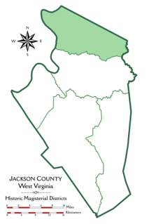
Grant District, formerly Grant Magisterial District, is one of five historic magisterial districts in Jackson County, West Virginia. The district was originally established as a civil township in 1863, and converted into a magisterial district in 1872. When Jackson County was redistricted in the 1990s, the area of Grant District was included in the new Northern Magisterial District. However, the county's historic magisterial districts continue to exist in the form of tax districts, serving all of their former administrative functions except for the election of county officials.
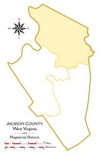
The Northern Magisterial District is one of three magisterial districts in Jackson County, West Virginia. It was established during a process of redistricting undertaken in the 1990s. In 2010, 8,753 people lived in the district.
