Rio Grande do Sul is a state in the southern region of Brazil. It is the fifth-most populous state and the ninth-largest by area. Located in the southernmost part of the country, Rio Grande do Sul is bordered clockwise by Santa Catarina to the north and northeast, the Atlantic Ocean to the east, the Uruguayan departments of Rocha, Treinta y Tres, Cerro Largo, Rivera, and Artigas to the south and southwest, and the Argentine provinces of Corrientes and Misiones to the west and northwest. The capital and largest city is Porto Alegre. The state has the highest life expectancy in Brazil, and the crime rate is relatively low compared to the Brazilian national average. The state has 5.4% of the Brazilian population and it is responsible for 6.6% of the Brazilian GDP.

Pelotas is a Brazilian city and municipality (município), the fourth most populous in the southern state of Rio Grande do Sul, after Porto Alegre, Caxias do Sul and Canoas. It is located 270 km (168 mi) from Porto Alegre, the state's capital city, and 130 km (80.8 mi) from the Uruguayan border. The Lagoa dos Patos lies to the east and the São Gonçalo Channel lies to the south, separating Pelotas from the city of Rio Grande.

Santa Maria is a municipality (município) in the central region of Rio Grande do Sul, the southernmost state of Brazil. In 2020, its population was 283,677 inhabitants in a total area of 1,823 square kilometres (704 sq mi). Santa Maria is the 5th biggest municipality in the state, and the largest in its micro-region.
Passo Fundo is a municipality in the north of the southern Brazilian state of Rio Grande do Sul. It is named after its river. It's the tenth largest city in the state with an estimated population of 204,722 inhabitants living in a total municipal area of 780 km2.

Grêmio Esportivo Brasil, commonly referred to as Brasil de Pelotas, is a Brazilian professional club based in Pelotas, Rio Grande do Sul founded on 7 September 1911. It competes in the Campeonato Brasileiro Série D, the fourth tier of Brazilian football, as well as in the Campeonato Gaúcho, the top flight of the Rio Grande do Sul state football league.

Barra do Quaraí is a Brazilian municipality located near the border with Uruguay and Argentina on the Uruguay River. The town became the westernmost city in the state of Rio Grande do Sul and in all Southern Brazil when it was separated from the municipality of Uruguaiana on December 28, 1995. The population is 4,227 in an area of 1056.14 km2. Its elevation is 35 m. It is located 717 km west of the state capital of Porto Alegre, and roughly the same distance northwest of Montevideo, Uruguay. Under Brazilian law, the municipality includes an island named Ilha Brasileira, also claimed by Uruguay, where it is known as Isla Brasilera.

Tapes is a municipality in Rio Grande do Sul state, Brazil, near to Porto Alegre. It is good for sailing, windsurfing, kitesurfing. Tapes

Rio Grande is a municipality (município) and one of the oldest cities in the Brazilian state of Rio Grande do Sul. It was the state capital from 1835 to 1845. It is the most important port city in the state and has one of the most important maritime ports in Brazil.

Caibaté is a municipality of the state of Rio Grande do Sul, Brazil. The population is 4,823 in an area of 259.66 km2. The name comes from the Tupi language. It is located 524 km west of the state capital of Porto Alegre, northeast of Alegrete.
Bossoroca is a municipality of the western part of the state of Rio Grande do Sul, Brazil. The population is 6,205 in an area of 1610.57 km2. The name comes from the Guarani language, and may mean erosion. It is located 524 km west of the state capital of Porto Alegre, northeast of Alegrete.

Catuípe is a municipality of the western part of the state of Rio Grande do Sul, Brazil. The population is 8,701 in an area of 583.26 km². Its nickname is Land of Spring Water for the springs located around the municipality. It is located 419 km west of the state capital of Porto Alegre, northeast of Alegrete.

Quarai is a Brazilian municipality located near the border with Uruguay on the Rio Quaraí. The population is 22,607 in an area of 3,147.63 km2, making it one of the largest municipalities in the state. Its elevation is 112 m. It is located 590 km west of the state capital of Porto Alegre, northeast of Montevideo, Uruguay and southeast of Alegrete.

Arroio Grande is a Brazilian municipality in the southern part of the state of Rio Grande do Sul. The population is 18,238 in an area of 2513.60 km². Its second industry is agriculture which was primary until the 1970s, it currently has more urban population (80%) than rural (20%). Much of the area is made up of plains.
Morro Redondo is a Brazilian municipality in the southern part of the state of Rio Grande do Sul. The population is 6,589 in an area of 244.65 km². It is located 35 km (21.75 mi) from Pelotas.

Pedro Osório is a Brazilian municipality in the southeastern part of the state of Rio Grande do Sul. The population is 7,706 in an area of 608.79 km2. The municipality was founded on April 3, 1958 from parts of the municipalities of Canguçú and Arroio Grande. Cerrito was separated in 1997.

Cerrito is a Brazilian municipality in the southern part of the state of Rio Grande do Sul. The population is 6,047 in an area of 451.70 km2. The municipality was formed in 1997 from part of the municipality Pedro Osório.
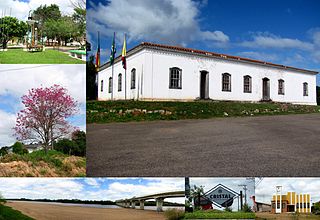
Cristal is a Brazilian municipality in the southeastern part of the state of Rio Grande do Sul. The population is 8,067 in an area of 681.63 km2. The Camaquã River flows through the municipality.

Vacaria is a municipality in the northeast of the southern Brazilian state of Rio Grande do Sul.

The BR-293 is an east-west highway in the state of Rio Grande do Sul, Brazil. The highway connects Pelotas to Quaraí, crossing important cities in the southern tip of Brazil such as Bagé and Santana do Livramento. The highway measures 535.7 km.

Sul-Rio-Grandense Federal Institute of Education, Science and Technology is a Brazilian federal public institution, linked to the Ministry of Education, which composes a Federal Network of Professional, Scientific and Technological Education. It is a multicenter institution, based on the combination of sets of teaching and communication modules in its different forms of teaching, based on the combination of sets of sessions and their respective technological processes.