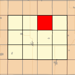
Carl Township, Adams County | |
|---|---|
 | |
| Coordinates: 41°06′32″N094°38′21″W / 41.10889°N 94.63917°W | |
| Country | |
| State | |
| County | Adams |
| Area | |
• Total | 35.8 sq mi (92.7 km2) |
| • Land | 35.61 sq mi (92.23 km2) |
| • Water | 0.18 sq mi (0.47 km2) |
| Elevation | 1,257 ft (383 m) |
| Population (2010) | |
• Total | 149 |
| • Density | 4.1/sq mi (1.6/km2) |
| Time zone | UTC-6 (CST) |
| • Summer (DST) | UTC-5 (CDT) |
| FIPS code | 19-90471 [2] |
| GNIS feature ID | 0467530 |
Carl Township is one of twelve townships in Adams County, Iowa, United States. At the 2010 census, its population was 149. [3]
