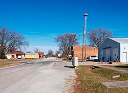
Nodaway, Iowa

Last updated

Nodaway, Iowa
Nodaway, IA.jpg
Adams County Iowa Incorporated and Unincorporated areas Nodaway Highlighted.svg
Location of Nodaway, Iowa
Coordinates: 40°56′10″N94°53′51″W / 40.93611°N 94.89750°W / 40.93611; -94.89750
Country Flag of the United States (23px).png  United States
State Flag of Iowa.svg  Iowa
County Adams
Township Nodaway
Area
[1]
  Total0.67 sq mi (1.73 km2)
  Land0.67 sq mi (1.73 km2)
  Water0.00 sq mi (0.00 km2)
Elevation
[2]
1,073 ft (327 m)
Population
 (2020)
  Total74
  Density110.61/sq mi (42.72/km2)
Time zone UTC-6 (Central (CST))
  Summer (DST) UTC-5 (CDT)
ZIP code
50857
Area code 712
FIPS code 19-56865
GNIS feature ID2395241 [2]

Nodaway is a city in Nodaway Township, Adams County, Iowa, United States. The population was 74 at the time of the 2020 census. [3] Nodaway was incorporated in 1900. [4]

Contents

History

Nodaway was a shipping point on the Chicago, Burlington and Quincy Railroad. [5]

Geography

According to the United States Census Bureau, the city has a total area of 0.54 square miles (1.40 km2), all land. [6]

Demographics

Historical populations
YearPop.±%
1880 109    
1910 323+196.3%
1920 340+5.3%
1930 334−1.8%
1940 270−19.2%
1950 233−13.7%
1960 204−12.4%
1970 176−13.7%
1980 185+5.1%
1990 153−17.3%
2000 132−13.7%
2010 114−13.6%
2020 74−35.1%
Source: "U.S. Census website". United States Census Bureau . Retrieved March 29, 2020. and Iowa Data Center
Source:
U.S. Decennial Census [7] [3]

2020 census

As of the census of 2020, [8] there were 74 people, 36 households, and 19 families residing in the city. The population density was 110.6 inhabitants per square mile (42.7/km2). There were 49 housing units at an average density of 73.3 per square mile (28.3/km2). The racial makeup of the city was 93.2% White, 1.4% Black or African American, 0.0% Native American, 0.0% Asian, 0.0% Pacific Islander, 1.4% from other races and 4.1% from two or more races. Hispanic or Latino persons of any race comprised 1.4% of the population.

Of the 36 households, 11.1% of which had children under the age of 18 living with them, 36.1% were married couples living together, 11.1% were cohabitating couples, 22.2% had a female householder with no spouse or partner present and 30.6% had a male householder with no spouse or partner present. 47.2% of all households were non-families. 36.1% of all households were made up of individuals, 19.4% had someone living alone who was 65 years old or older.

The median age in the city was 48.5 years. 24.3% of the residents were under the age of 20; 1.4% were between the ages of 20 and 24; 21.6% were from 25 and 44; 20.3% were from 45 and 64; and 32.4% were 65 years of age or older. The gender makeup of the city was 52.7% male and 47.3% female.

2010 census

At the 2010 census there were 114 people in 47 households, including 31 families, in the city. The population density was 211.1 inhabitants per square mile (81.5/km2). There were 62 housing units at an average density of 114.8 per square mile (44.3/km2). The racial makup of the city was 98.2% White and 1.8% from two or more races. [9]

Of the 47 households 27.7% had children under the age of 18 living with them, 51.1% were married couples living together, 8.5% had a female householder with no husband present, 6.4% had a male householder with no wife present, and 34.0% were non-families. 29.8% of households were one person and 10.6% were one person aged 65 or older. The average household size was 2.43 and the average family size was 3.00.

The median age was 39 years. 27.2% of residents were under the age of 18; 4.4% were between the ages of 18 and 24; 21.2% were from 25 to 44; 29% were from 45 to 64; and 18.4% were 65 or older. The gender makeup of the city was 50.0% male and 50.0% female.

2000 census

As of the census [10] of 2000, there were 132 people in 58 households, including 38 families, in the city. The population density was 254.0 inhabitants per square mile (98.1/km2). There were 70 housing units at an average density of 134.7 per square mile (52.0/km2). The racial makup of the city was 100.00% White.

Of the 58 households 29.3% had children under the age of 18 living with them, 56.9% were married couples living together, 6.9% had a female householder with no husband present, and 32.8% were non-families. 29.3% of households were one person and 22.4% were one person aged 65 or older. The average household size was 2.28 and the average family size was 2.77.

Age spread: 22.0% under the age of 18, 5.3% from 18 to 24, 18.2% from 25 to 44, 31.8% from 45 to 64, and 22.7% 65 or older. The median age was 48 years. For every 100 females, there were 94.1 males. For every 100 females age 18 and over, there were 94.3 males.

The median household income was $34,375 and the median family income was $34,792. Males had a median income of $31,750 versus $21,667 for females. The per capita income for the city was $16,722. There were 8.9% of families and 11.6% of the population living below the poverty line, including 26.1% of under eighteens and 12.5% of those over 64.

Education

Nodaway is within the Villisca Community School District. [11] Residents are zoned to Southwest Valley High School, operated by the Corning Community School District, and shared with the Villisca district as part of a grade-sharing agreement. [12]

Related Research Articles

<span class="mw-page-title-main">Bridgewater, Iowa</span> City in Iowa, United States

Bridgewater is a city in Jackson Township, Adair County, Iowa, United States. The population was 148 at the time of the 2020 census. Bridgewater was founded in 1885.

<span class="mw-page-title-main">Fontanelle, Iowa</span> City in Iowa, United States

Fontanelle is a city in Summerset Township, Adair County, Iowa, United States. The population was 676 at the time of the 2020 census.

<span class="mw-page-title-main">Carbon, Iowa</span> Hamlet in Iowa, United States

Carbon is a rural hamlet in Douglas Township, Adams County, Iowa, United States. The population was 36 at the 2020 census. There is a church at Carbon, and a community center, and no other businesses or services. It is the 24th smallest place in Iowa by population.

<span class="mw-page-title-main">Corning, Iowa</span> City in Iowa, United States

Corning is a city in Quincy Township, Adams County, Iowa, United States. The population was 1,564 at the 2020 census. It is the county seat of Adams County. Corning is located just north of the intersection of U.S. Route 34 and Iowa Highway 148. Corning is perhaps best known as the birthplace of Johnny Carson. Daniel Webster Turner, who was governor of Iowa from 1931 to 1933, was born in Corning on March 17, 1877.

<span class="mw-page-title-main">Villisca, Iowa</span> City in Iowa, United States

Villisca is a city in Montgomery County, Iowa, United States. The population was 1,132 at the time of the 2020 census. It is most notable for the unsolved axe mass murder that took place in the town during the summer of 1912.

<span class="mw-page-title-main">Braddyville, Iowa</span> City in Iowa, United States

Braddyville is a city in Page County, Iowa, United States. The population was 147 at the 2020 census.

<span class="mw-page-title-main">Shambaugh, Iowa</span> City in Iowa, United States

Shambaugh is a city in Page County, Iowa, United States. The population was 159 at the time of the 2020 census.

<span class="mw-page-title-main">Arkoe, Missouri</span> Village in Missouri, United States

Arkoe is a village in Nodaway County, Missouri, United States. The population was 68 at the 2010 census.

<span class="mw-page-title-main">Barnard, Missouri</span> City in Missouri, United States

Barnard is a city in Nodaway County, Missouri, United States. As of the 2020 census, the city population was 201.

<span class="mw-page-title-main">Burlington Junction, Missouri</span> City in Missouri, United States

Burlington Junction is a city in Nodaway County, Missouri, United States. The population was 521 at the 2020 census.

<span class="mw-page-title-main">Clearmont, Missouri</span> City in Missouri, United States

Clearmont is a city in northwest Nodaway County, Missouri, United States. The population was 158 at the 2020 census.

<span class="mw-page-title-main">Clyde, Missouri</span> Village in Missouri, United States

Clyde is a village in eastern Nodaway County, Missouri, United States. The population was 55 at the 2020 census.

<span class="mw-page-title-main">Conception Junction, Missouri</span> City in Missouri, United States

Conception Junction is a city in Nodaway County, Missouri, United States, near the Platte River. The population was 177 at the 2020 census.

<span class="mw-page-title-main">Elmo, Missouri</span> City in Missouri, United States

Elmo is a city in Nodaway County, Missouri, United States. The population was 168 at the 2010 census.

<span class="mw-page-title-main">Graham, Missouri</span> City in Missouri, United States

Graham is a city in Nodaway County, Missouri, United States. The population was 171 at the 2010 census.

<span class="mw-page-title-main">Guilford, Missouri</span> Village in Missouri, United States

Guilford is a village in Nodaway County, Missouri, United States, near the Platte River. The population was 85 at the 2010 census.

<span class="mw-page-title-main">Pickering, Missouri</span> Village in Missouri, United States

Pickering is a city in Nodaway County, Missouri, United States. The population was 160 at the 2010 census.

<span class="mw-page-title-main">Quitman, Missouri</span> Unincorporated community in Missouri, United States

Quitman is an unincorporated community in west central Nodaway County, Missouri, United States. The population was 45 at the 2010 census.

<span class="mw-page-title-main">Ravenwood, Missouri</span> City in Missouri, United States

Ravenwood is a city in eastern Nodaway County, Missouri, United States, near the Platte River. The population was 439 at the 2020 census.

<span class="mw-page-title-main">Skidmore, Missouri</span> City in Missouri, United States

Skidmore is a city in western Nodaway County, Missouri, United States. The population was 245 at the 2020 Census. The small farming community is known for the unsolved extrajudicial killing of Ken Rex McElroy. Skidmore also has a yearly "Punkin' Show."

References

  1. "2020 U.S. Gazetteer Files". United States Census Bureau. Retrieved March 16, 2022.
  2. 1 2 U.S. Geological Survey Geographic Names Information System: Nodaway, Iowa
  3. 1 2 "2020 Census State Redistricting Data". census.gov. United states Census Bureau. Retrieved August 12, 2021.
  4. History of Nodaway
  5. A dictionary of altitudes in the United States. Govt. Print. Off. 1892. p. 255.
  6. "US Gazetteer files 2010". United States Census Bureau. Archived from the original on January 12, 2012. Retrieved May 11, 2012.
  7. "Census of Population and Housing". Census.gov. Retrieved June 4, 2015.
  8. "2020 Census". United States Census Bureau.
  9. "U.S. Census website". United States Census Bureau . Retrieved May 11, 2012.
  10. "U.S. Census website". United States Census Bureau . Retrieved January 31, 2008.
  11. "Villisca." Iowa Department of Education. Retrieved on July 15, 2018.
  12. Home. Southwest Valley Schools (joint website operated by the Corning and Villisca districts). Retrieved on July 15, 2018.