Carlsbergfondet Land

Last updated
Carlsbergfondet Land
Carlsbergfondet Land 2016-08-01-23 59 Sentinel-2 L1C True color.jpg
Carlsbergfondet Land Sentinel-2 image
Highest point
PeakDickens Bjerg
Elevation 2,275 m (7,464 ft)
Dimensions
Length35 km (22 mi)E/W
Width27 km (17 mi)N/S
Geography
Country Greenland
Range coordinates 76°33′N24°00′W / 76.550°N 24.000°W / 76.550; -24.000

Carlsbergfondet Land is a group of nunataks in Queen Louise Land, NE Greenland. Administratively it is part of the Northeast Greenland National Park zone. [1]

Contents

History

The area was named "Carlsbergfondets Land" during the 1912–13 Danish Expedition to Queen Louise Land led by J.P. Koch. The Carlsberg Foundation (Danish : Carlsbergfondet) had been the most generous single contributor at the time of financing the venture. [2]

In May-June 2007 an expedition led by Russ Hore with Gerwyn Lloyd and Tim Radford climbed some of the peaks of the nunataks rising to the west, as well as in the Eventyrfjelde area to the south. [3]

Geography

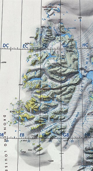
Carlsbergfondet Land is a sector at the southwestern end of Queen Louise Land, to the south of the Budolfi Isstrom and to the north of the A.B. Drachmann Glacier. The Ebbe Glacier forms the limit to the east and to the west there are dispersed nunataks until the land ends in the vast, empty Greenland ice sheet. [4] [1]

The highest peak in the nunatak group lies to the northwest and is 2,275-metre-high (7,464 ft). [5] It is erroneously marked as a 8,799-foot-high (2,682 m) peak in the Defense Mapping Agency Greenland Navigation charts. [6]

Queen Louise Land and neighbouring areas (annotated). Dronning Louise Land-NE Greenland.jpg
Queen Louise Land and neighbouring areas (annotated).

See also

Related Research Articles

Mount Rigny is a mountain peak in East Greenland. It is located in King Christian IX Land, Sermersooq Municipality.

Lindhard Island is an uninhabited island of NE Greenland.
<span class="mw-page-title-main">Watkins Range</span> Mountain range in Greenland

The Watkins Range is Greenland's highest mountain range. It is located in King Christian IX Land, Sermersooq municipality.

<span class="mw-page-title-main">King Frederick VIII Land</span> Region in Greenland

King Frederick VIII Land is a major geographic division of northeastern Greenland. It extends above the Arctic Circle from 76°N to 81°N in a North-South direction along the coast of the Greenland Sea.

<span class="mw-page-title-main">Mount Paatusoq</span>

Mount Paatusoq, also known as 'Mount Patuersoq', is the highest mountain in the Kujalleq municipality, SE Greenland.

Petermann Peak,, also known as Petermann Fjeld, Petermanns Topp and Petermann Point is a mountain in King Christian X Land, Northeast Greenland. Administratively it is part of the Northeast Greenland National Park zone.
<span class="mw-page-title-main">Queen Louise Land</span> Mountainous region in northeastern Greenland

Queen Louise Land is a vast mountainous region located west of Dove Bay, King Frederick VIII Land, northeastern Greenland. Administratively it is part of the Northeast Greenland National Park zone.

<span class="mw-page-title-main">Revaltoppe</span> Mountain in Greenland

Revaltoppe is one of the highest mountains in Queen Louise Land, NE Greenland. The peak is located in the King Frederick VIII Land area of northeastern Greenland. Administratively it is part of the Northeast Greenland National Park zone.

<span class="mw-page-title-main">Gefiontinde</span>

Gefiontinde is the highest mountain in Queen Louise Land, NE Greenland. The peak is located in the King Frederick VIII Land area of northeastern Greenland. Administratively it is part of the Northeast Greenland National Park zone.

Akuliarutsip Sermerssua, also known as Nordenskiöld Glacier,, is a large glacier located on the east coast of Greenland.

<span class="mw-page-title-main">Lindbergh Range</span> Mountain range in Greenland

The Lindbergh Range or Lindbergh Nunataks is a mountain range in King Christian IX Land, eastern Greenland. Administratively the range is part of the Sermersooq Municipality.

Mount Wistar is a mountain in Peary Land, Northern Greenland. Administratively it is part of the Northeast Greenland National Park.

Louise Boyd Land is an area in King Christian X Land, Eastern Greenland. Administratively it lies in the Northeast Greenland National Park zone. The area is remote and uninhabited.

Pic de Gerlache is a mountain in King Frederick VIII Land, NE Greenland. Administratively it is part of the Northeast Greenland National Park.

<span class="mw-page-title-main">Britannia Glacier</span> Glacier in northeastern Greenland

Britannia Glacier is a glacier in Queen Louise Land, northeastern Greenland. Administratively it belongs to the Northeast Greenland National Park.

<span class="mw-page-title-main">Ymer Nunatak</span> Mountain feature in Greenland

Ymer Nunatak is a nunatak in the Queen Louise Land area of northeastern Greenland. Administratively it is part of the Northeast Greenland National Park zone.

<span class="mw-page-title-main">Eventyrfjelde</span>

Eventyrfjelde is a group of nunataks in Queen Louise Land, NE Greenland. Administratively it is part of the Northeast Greenland National Park zone.
<span class="mw-page-title-main">Borgjokel</span> Glacier in northeastern Greenland

Borgjokel is a glacier in Queen Louise Land, northeastern Greenland. Administratively it belongs to the Northeast Greenland National Park.

References

  1. 1 2 Google Earth
  2. "Place names, northern East Greenland". data.geus.dk. Retrieved 2023-10-19.
  3. Alpine Journal 2008 p. 154
  4. GEUS Map - Northern East Greenland; Geological Survey of Denmark and Greenland Bulletin 21 Map 4 - 1:1 000 000
  5. Queen Louise Land Mountains, Petter Bjørstad
  6. 1:1,000,000 scale Operational Navigation Chart, Sheet B-9