
Ulster County is a county in the U.S. state of New York. It is situated along the Hudson River. As of the 2020 census, the population was 181,851. The county seat is Kingston. The county is named after the Irish province of Ulster. The county is part of the Hudson Valley region of the state.

Rosendale is a hamlet located in the Town of Rosendale in Ulster County, New York, United States. The population was 1,285 at the 2020 census. It was also a census-designated place known as Rosendale Village until 2010, when the U.S. Census Bureau designated it Rosendale Hamlet. Some maps continue to list the place as just Rosendale. As of 2020, the "Hamlet" in the CDP name was dropped.

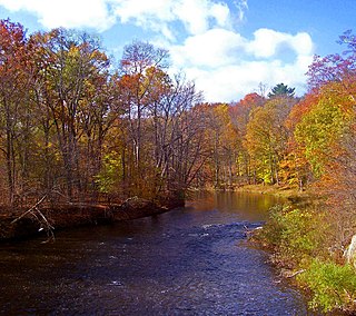
The Wallkill River, a tributary of the Hudson, drains Lake Mohawk in Sparta, New Jersey, flowing from there generally northeasterly 88.3 miles (142.1 km) to Rondout Creek in New York, just downstream of Sturgeon Pool, near Rosendale, with the combined flows reaching the Hudson at Kingston.

Perrine's Bridge is the second-oldest covered bridge in the State of New York, after the Hyde Hall Bridge in East Springfield. Once located in the hamlet called Perrines Bridge between 1850 and 1861. It is located in the modern day town of Esopus-Rosendale, New York just a few hundred feet to the east of Interstate 87 crossing of the Wallkill River in Ulster County, New York. Originally built to aid in the movement of trade between the towns of Rifton and Rosendale, the bridge is about 90 miles north of New York city between mile markers 81 and 82 on the New York State Thruway. In May 1834 the State of New York authorized and provided money ($700) to Ulster county, NY, to build the bridge. In 1835, the bridge was built by Benjamin Wood, the one-lane wooden covered bridge has been closed to vehicular traffic since 1930. The Bridge derives its name from James W. Perrine, a descendant of Daniel Perrin "The Huguenot", who was a tavern keeper that opened an inn on the east side of that future bridge in 1820. Perrine's son was hired each winter as the "snower". He would spread snow the length of the structure so horse-drawn sleighs could cross.

New York State Route 208 (NY 208) is a state highway located in southern New York in the United States. The southern terminus is at an intersection with NY 17M in the Orange County village of Monroe. Its northern terminus is located at an intersection with NY 32 and NY 299 in the Ulster County village of New Paltz.

New York State Route 299 (NY 299) is a short but important state route entirely within Ulster County, New York, in the United States. Centered on its interchange with the New York State Thruway outside New Paltz, it provides access from that road to the popular recreational attractions of the Shawangunk Ridge to the west and Poughkeepsie to the east. Only the eastern section is a state highway; from Shawangunk to New Paltz, it is owned and maintained by Ulster County.

The Wallkill Valley Railroad is a defunct railroad which once operated in Ulster and Orange counties in upstate New York. Its corridor was from Kingston in the north to Montgomery in the south, with a leased extension to Campbell Hall. It crossed both the Wallkill River and Rondout Creek.
The Shawangunk Kill is a 47.2-mile-long (76.0 km) stream that flows northward through Orange, Sullivan and Ulster counties, New York, in the United States. It is the largest tributary of the Wallkill River.

The New Hurley Reformed Church, listed on the National Register of Historic Places (NRHP) as the Reformed Dutch Church of New Hurley, is located on New York State Route 208 roughly 3 miles (4.8 km) north of the hamlet of Wallkill, New York, United States, midway between it and Gardiner to the north, in the town of Plattekill. It is a wooden structure built in the Greek Revival style during the 1830s. In 1982 it was listed on the NRHP.

The Wallkill Valley Rail Trail is a 23.7-mile (38.1 km) rail trail and linear park that runs along the former Wallkill Valley Railroad rail corridor in Ulster County, New York, United States. It stretches from Gardiner through New Paltz, Rosendale and Ulster to the Kingston city line, just south of a demolished, concrete Conrail railroad bridge that was located on a team-track siding several blocks south of the also-demolished Kingston New York Central Railroad passenger station. The trail is separated from the Walden–Wallkill Rail Trail by two state prisons in Shawangunk, though there have been plans to bypass these facilities and to connect the Wallkill Valley Rail Trail with other regional rail-trails. The northern section of the trail forms part of the Empire State Trail.

Tuthilltown Bridge is located in the Town of Gardiner in Ulster County, New York, United States, approximately 1 miles (1.6 km) west of the eponymous hamlet. It carries US 44/NY 55 across the north-flowing Wallkill River just downstream from where it is joined by the Shawangunk Kill, its largest tributary. It is a steel through truss bridge built in 1938 and reconstructed in 1993

The Dwaar Kill is a 17-mile-long (27 km) tributary of the Wallkill River that drains a 28-square-mile (73 km2) area of Orange and Ulster counties in the U.S. state of New York. It is the Wallkill's second-longest tributary after the Shawangunk Kill, whose course it parallels somewhat to the east.

The Walden–Wallkill Rail Trail, also known as the Jesse McHugh Rail Trail, is a 3.22-mile (5.18 km) rail trail between the village of Walden and the neighboring hamlet of Wallkill. The two communities are located in Orange County and Ulster County, respectively, in upstate New York.

Gardiner is a town in the south-central part of Ulster County, New York, United States. The population was 5,610 at the 2020 census.

New Paltz is a village in Ulster County located in the U.S. state of New York. It is approximately 80 miles (130 km) north of New York City and 70 miles (110 km) south of Albany. The population was 7,324 at the 2020 census.

New Paltz is an incorporated U.S. town in Ulster County, New York. The population was 14,407 at the 2020 census. The town is located in the southeastern part of the county and is south of Kingston. New Paltz contains a village, also with the name New Paltz. The town is named for Palz, the dialect name of the Palatinate, called Pfalz in standard German.

The Hudson Valley Rail Trail is a paved 4-mile (6.4 km) east–west rail trail in the town of Lloyd in Ulster County, New York, stretching from the Hudson River through the hamlet of Highland. The trail was originally part of the Poughkeepsie Bridge Route, a rail corridor that crossed the Hudson via the Poughkeepsie Bridge. Controlled by a variety of railroads throughout the 19th and 20th centuries, the bridge was damaged and became unusable after a May 8, 1974 fire. By the 1980s, the corridor's then-owner, Conrail, had routed all rail traffic in the region north through Selkirk Yard and was eager to relieve itself of the bridge and adjoining rights-of-way. In 1984, it sold the entire property for one dollar to a felon who did not maintain it or pay taxes on it. The section of the corridor west of the Hudson was seized by Ulster County in 1991 and transferred to the town of Lloyd.

The Rosendale Trestle is a 940-foot (290-meter) continuous truss bridge and former railroad trestle in Rosendale Village, a hamlet in the town of Rosendale in Ulster County, New York. Originally constructed by the Wallkill Valley Railroad to continue its rail line from New Paltz to Kingston, the bridge rises 150 ft (46 m) above Rondout Creek, spanning both Route 213 and the former Delaware and Hudson Canal. Construction on the trestle began in late 1870, and continued until early 1872. When it opened to rail traffic on April 6, 1872, the Rosendale trestle was the highest span bridge in the United States.

New Paltz station is a former train station in the village of New Paltz in Ulster County, New York. The building was the first of two railroad stations constructed in the town of New Paltz, and it is the only former Wallkill Valley Railroad station standing at its original location.
The Verkeerder Kill, sometimes Verkeerderkill and locally shortened to Kaidy Kill is an 8-mile-long (13 km) stream in Ulster County, New York, United States. It rises on the Shawangunk Ridge, in the town of Wawarsing, and flows southwards through the town of Shawangunk, toward the Shawangunk Kill, itself a major tributary of the Wallkill River. Ultimately it is a part of the Hudson River's watershed.

