Tillson, New York

Last updated
Tillson, New York
CDP
Downtown Tillson, NY.jpg
Tillson, looking north along the main highway
Ulster County New York incorporated and unincorporated areas Tillson highlighted.svg
Location in Ulster County and the state of New York.
Coordinates: 41°49′52″N74°4′19″W / 41.83111°N 74.07194°W / 41.83111; -74.07194 Coordinates: 41°49′52″N74°4′19″W / 41.83111°N 74.07194°W / 41.83111; -74.07194
Country United States
State New York
County Ulster
Area
[1]
  Total2.37 sq mi (6.14 km2)
  Land2.35 sq mi (6.07 km2)
  Water0.02 sq mi (0.06 km2)
Elevation
233 ft (71 m)
Population
 (2020)
  Total1,516
  Density646.48/sq mi (249.61/km2)
Time zone UTC-5 (Eastern (EST))
  Summer (DST) UTC-4 (EDT)
ZIP code
12486
Area code 845
FIPS code 36-73902
GNIS feature ID0967526

Tillson is a hamlet (and census-designated place) in Ulster County, New York, United States. The population was 1,586 at the 2010 census.

Contents

Tillson is in the Town of Rosendale, along routes 32 and 213.

Geography

Tillson is located at 41°49′52″N74°4′19″W / 41.83111°N 74.07194°W / 41.83111; -74.07194 (41.831082, -74.072072). [2]

According to the United States Census Bureau, the CDP has a total area of 2.3 square miles (6.0 km2), of which 2.3 square miles (6.0 km2) is land and 0.04 square miles (0.10 km2) (1.28%) is water.

Demographics

Historical population
CensusPop.
2020 1,516
U.S. Decennial Census [3]

As of the census [4] of 2000, there were 1,709 people, 629 households, and 452 families residing in the CDP. The population density was 738.4 per square mile (285.6/km2). There were 676 housing units at an average density of 292.1/sq mi (113.0/km2). The racial makeup of the CDP was 96.96% White, 1.05% African American, 0.29% Native American, 0.23% Asian, 0.06% from other races, and 1.40% from two or more races. Hispanic or Latino of any race were 1.93% of the population.

There were 629 households, out of which 37.4% had children under the age of 18 living with them, 58.7% were married couples living together, 9.5% had a female householder with no husband present, and 28.0% were non-families. 20.0% of all households were made up of individuals, and 8.7% had someone living alone who was 65 years of age or older. The average household size was 2.72 and the average family size was 3.16.

In the CDP, the population was spread out, with 28.8% under the age of 18, 5.4% from 18 to 24, 33.0% from 25 to 44, 21.2% from 45 to 64, and 11.6% who were 65 years of age or older. The median age was 36 years. For every 100 females, there were 95.5 males. For every 100 females age 18 and over, there were 91.4 males.

The median income for a household in the CDP was $47,083, and the median income for a family was $51,375. Males had a median income of $38,696 versus $27,298 for females. The per capita income for the CDP was $19,413. About 7.1% of families and 14.5% of the population were below the poverty line, including 26.6% of those under age 18 and 6.3% of those age 65 or over.

Related Research Articles

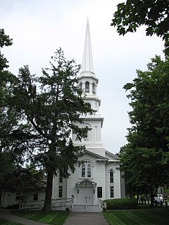
Old Saybrook Center is a community and census-designated place (CDP) in Old Saybrook, a town in Middlesex County, Connecticut, United States. The population was 1,962 at the 2000 census. The CDP includes the traditional town center and the peninsula known as Saybrook Point.

<span class="mw-page-title-main">Laguna Beach, Florida</span> Census-designated place in Florida, United States

Laguna Beach is a census-designated place (CDP) in Bay County, Florida, United States. The population was 3,932 at the 2010 census. It is part of the Panama City–Lynn Haven–Panama City Beach Metropolitan Statistical Area. Laguna Beach was named for the many coastal dune lakes unique to this area of Northwest Florida.

<span class="mw-page-title-main">Palmona Park, Florida</span> Census-designated place in Florida, United States

Palmona Park is a census-designated place (CDP) in Lee County, Florida, United States. The population was 1,146 at the 2010 census, down from 1,353 at the 2000 census. It is part of the Cape Coral-Fort Myers, Florida Metropolitan Statistical Area.

<span class="mw-page-title-main">North Sarasota, Florida</span> Census-designated place in Florida, United States

North Sarasota is a census-designated place (CDP) in Sarasota County, Florida, United States. The population was 6,982 at the 2010 census. It is part of the Bradenton–Sarasota–Venice Metropolitan Statistical Area.

<span class="mw-page-title-main">Southgate, Florida</span> Census-designated place in Florida, United States

Southgate is a census-designated place (CDP) in Sarasota County, Florida, United States. The population was 7,173 at the 2010 census. It is part of the Bradenton–Sarasota–Venice Metropolitan Statistical Area.

Rosewood Heights is a census-designated place (CDP) in Madison County, Illinois, United States. The population was 4,038 at the 2010 census.

<span class="mw-page-title-main">Harwich Center, Massachusetts</span> Census-designated place in Massachusetts, United States

Harwich Center is a census-designated place (CDP) in the town of Harwich in Barnstable County, Massachusetts, United States. The population was 1,798 at the 2010 census.

<span class="mw-page-title-main">Orr, Minnesota</span> City in Minnesota, United States

Orr is a city in Saint Louis County, Minnesota, United States. The population was 211 at the 2020 census.

<span class="mw-page-title-main">Firthcliffe, New York</span> CDP in New York, United States

Firthcliffe is a hamlet in Orange County, New York United States. The population was 4,949 at the 2010 census. It is part of the Poughkeepsie–Newburgh–Middletown, NY Metropolitan Statistical Area as well as the larger New York–Newark–Bridgeport, NY-NJ-CT-PA Combined Statistical Area.

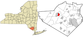
Highland Mills is a hamlet and former census-designated place (CDP) in Orange County, New York, United States. The population was 3,468 at the 2000 census. It is part of the Poughkeepsie–Newburgh–Middletown, NY Metropolitan Statistical Area as well as the larger New York–Newark–Bridgeport, NY-NJ-CT-PA Combined Statistical Area.

<span class="mw-page-title-main">Mechanicstown, New York</span> CDP in New York, United States

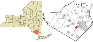
Mechanicstown is a hamlet in Orange County, New York, United States. The population was 6,061 at the 2000 census and 6,858 as of the 2010 census. It is part of the Poughkeepsie–Newburgh–Middletown, NY Metropolitan Statistical Area as well as the larger New York–Newark–Bridgeport, NY-NJ-CT-PA Combined Statistical Area.

<span class="mw-page-title-main">Walton Park, New York</span> CDP in New York, United States

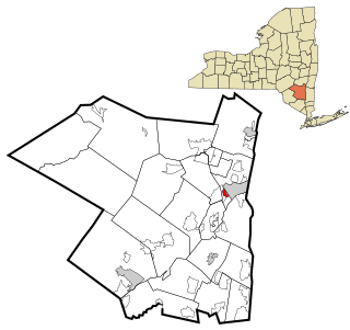
Walton Park is a census-designated place (CDP) in Orange County, New York, United States. As of the 2010 census, the CDP had a total population of 2,669.

<span class="mw-page-title-main">Washington Heights, New York</span> CDP in New York, United States

Washington Heights is a census-designated place (CDP) in Orange County, New York, United States. The population was 2,205 at the 2020 census.

<span class="mw-page-title-main">Clintondale, New York</span> CDP in New York, United States

Clintondale is a hamlet in Ulster County, New York, United States. The population was 1,452 at the 2010 census.

<span class="mw-page-title-main">Hillside, New York</span> CDP in New York, United States

Hillside is a census-designated place (CDP) in Ulster County, New York, United States. The population was 877 at the 2010 census.

<span class="mw-page-title-main">West Hill, Ohio</span> CDP in Ohio, United States

West Hill is a census-designated place (CDP) in Trumbull County, Ohio, United States. The population was 2,523 at the 2000 census. It is part of the Youngstown–Warren–Boardman, OH-PA Metropolitan Statistical Area.

<span class="mw-page-title-main">Pymatuning South, Pennsylvania</span> Census-designated place in Pennsylvania, United States

Pymatuning South is a census-designated place (CDP) in Crawford County, Pennsylvania, United States. The population was 479 at the 2010 census.

Ravine is a census-designated place (CDP) in Schuylkill County, Pennsylvania, United States. The population was 629 at the 2000 census.

<span class="mw-page-title-main">Gardiner (CDP), New York</span> CDP in New York, United States

Gardiner is a hamlet in Ulster County, New York, United States. The population was 950 at the 2010 census.

<span class="mw-page-title-main">Plattekill (CDP), New York</span> CDP in New York, United States

Plattekill is a hamlet in Ulster County, New York, United States. The population was 1,260 at the 2010 census. The community, as is the town, is named after a local stream, the Platte Kill.

References

  1. "ArcGIS REST Services Directory". United States Census Bureau. Retrieved September 20, 2022.
  2. "US Gazetteer files: 2010, 2000, and 1990". United States Census Bureau. 2011-02-12. Retrieved 2011-04-23.
  3. "Census of Population and Housing". Census.gov. Retrieved June 4, 2016.
  4. "U.S. Census website". United States Census Bureau . Retrieved 2008-01-31.