Leitersburg is a census-designated place (CDP) in Washington County, Maryland, United States. The population was 523 at the 2000 census.

South Dennis is a census-designated place (CDP) in the town of Dennis in Barnstable County, Massachusetts, United States. The population was 3,643 at the 2010 census, the most of the 5 CDPs in Dennis.
Central Valley is a hamlet in Orange County, New York, United States. The population was 1,857 at the 2000 census, at which time it was a census-designated place. It is part of the Poughkeepsie–Newburgh–Middletown, NY Metropolitan Statistical Area as well as the larger New York–Newark–Bridgeport, NY-NJ-CT-PA Combined Statistical Area.

Firthcliffe is a hamlet in Orange County, New York United States. The population was 5,022 at the 2020 Census. It is part of the Poughkeepsie–Newburgh–Middletown, NY Metropolitan Statistical Area as well as the larger New York–Newark–Bridgeport, NY-NJ-CT-PA Combined Statistical Area.
Mechanicstown is a hamlet in Orange County, New York, United States. The population was 8,065 at the 2020 census. It is part of the Poughkeepsie–Newburgh–Middletown, NY Metropolitan Statistical Area as well as the larger New York–Newark–Bridgeport, NY-NJ-CT-PA Combined Statistical Area.

Washington Heights is a census-designated place (CDP) in Orange County, New York, United States. The population was 2,205 at the 2020 census.
Brasher Falls–Winthrop was a census-designated place (CDP) in St. Lawrence County, New York, United States. As of the 2000 census, its population was 1,140. For the 2010 census, the area was counted as two separate CDPs: Brasher Falls in the Town of Brasher and Winthrop in the Town of Stockholm.

Accord is a hamlet and census-designated place (CDP) in Ulster County, New York, United States. Accord is located in the eastern part of the Town of Rochester along US 209. Accord is the seat of town government. As of the 2020 census the population is 573.

Tillson is a hamlet in Ulster County, New York, United States. The population was 1,516 at the 2020 census.

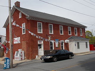
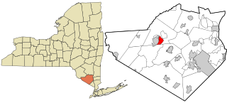
Walker Valley is a hamlet located in the western part of the Town of Shawangunk in Ulster County, New York, United States, generally thought of as coterminous with the 12588 ZIP code. The population was 1,269 at the 2020 census.

Dennis is an unincorporated community and census-designated place (CDP) in Delaware County, Oklahoma, near Grand Lake. The population was 195 at the 2010 census. The Dennis Post Office existed from March 25, 1914, until January 31, 1956. It is said to be named for a local resident, Peter Dennis.

Monument is an unincorporated community and census-designated place in Centre County, Pennsylvania, United States. It is part of the State College, Pennsylvania Metropolitan Statistical Area. The population was 150 at the 2010 census.

Lasana is a census-designated place (CDP) in Cameron County, Texas, United States. The population was 84 at the 2010 census, down from 135 at the 2000 census. It is part of the Brownsville–Harlingen Metropolitan Statistical Area.

Frederickson is a census-designated place (CDP) in Pierce County, Washington, United States. The population was 24,906 at the 2020 census.

Slater is a census-designated place (CDP) in Platte County, Wyoming, United States. The population was 80 at the 2010 census.

Chatham is a census-designated place (CDP) in the town of Chatham in Barnstable County, Massachusetts, United States. The population was 1,421 at the 2010 census, out of 6,125 in the entire town of Chatham.

Winchendon is a census-designated place (CDP) in the town of Winchendon in Worcester County, Massachusetts, United States. The population was 4,213 at the 2010 census.

Eastchester is a census-designated place (CDP) in Westchester County, New York, United States. The population was 19,554 at the 2010 census. The Eastchester CDP consists of the Town of Eastchester excluding the villages of Bronxville and Tuckahoe.

Gardiner is a hamlet in Ulster County, New York, United States. The population was 952 at the 2020 census.

Plattekill is a hamlet in Ulster County, New York, United States. The population was 1,296 at the 2020 census. The community, as is the town, is named after a local stream, the Platte Kill.


