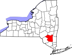
Marbletown, New York

Last updated
Marbletown, New York
Ulster County New York incorporated and unincorporated areas Marbletown highlighted.svg
Location in Ulster County and the state of New York.
Coordinates: 41°51′12″N74°9′21″W / 41.85333°N 74.15583°W / 41.85333; -74.15583
Country United States
State New York
County Ulster
Area
[1]
  Total55.18 sq mi (142.92 km2)
  Land54.47 sq mi (141.08 km2)
  Water0.71 sq mi (1.84 km2)
Elevation
837 ft (255 m)
Population
 (2020)
  Total5,658
  Density101.34/sq mi (39.13/km2)
Time zone UTC-5 (Eastern (EST))
  Summer (DST) UTC-4 (EDT)
FIPS code 36-45458
GNIS feature ID0979195
Website Town website

Marbletown is a town in Ulster County, New York, United States. The population was 5,658 at the 2020 census. It is located near the center of Ulster County, southwest of the City of Kingston. US 209 and NY 213 pass through the town. It is at the eastern edge of the Catskill Park.

Contents

History

The area was settled around 1638, and received its patent (to Henry Beekman, Thomas Garton, and Charles Brodhead) in 1703. The community of Marbletown once served briefly as the state capital, after the city of Kingston was burned by the British during the American Revolutionary War. [2] Part of Marbletown was used in 1823 to form the Town of Olive and another part was used in 1844 to form the Town of Rosendale. The town of Marbletown was formed in 1788.

The Bevier Stone House, Rest Plaus Historic District, Cornelius Wynkoop Stone House and Mohonk Mountain House are listed on the National Register of Historic Places. [3]

Geography

According to the United States Census Bureau, the town has a total area of 55.2 square miles (143 km2), of which 54.6 square miles (141 km2) is land and 0.6 square miles (1.6 km2) (1.11%) is water.

The Rondout Creek and Esopus Creek flow through the town.

Demographics

Historical population
CensusPop.Note
1820 3,809
1830 3,223−15.4%
1840 3,81318.3%
1850 3,8300.4%
1860 4,1207.6%
1870 4,2232.5%
1880 3,970−6.0%
1890 3,639−8.3%
1900 3,511−3.5%
1910 4,71334.2%
1920 2,017−57.2%
1930 2,27612.8%
1940 2,54311.7%
1950 2,364−7.0%
1960 3,19135.0%
1970 4,14629.9%
1980 4,95619.5%
1990 5,2856.6%
2000 5,85410.8%
2010 5,607−4.2%
2020 5,6580.9%
U.S. Decennial Census [4] [5]

As of the census [6] of 2000, there were 5,854 people, 2,386 households, and 1,598 families residing in the town. The population density was 107.3 inhabitants per square mile (41.4/km2). There were 2,846 housing units at an average density of 52.1 per square mile (20.1/km2). The racial makeup of the town was 95.46% white, 1.38% African American, 0.22% Native American, 0.70% Asian, 0.53% from other races, and 1.71% from two or more races. Hispanic or Latino of any race were 2.07% of the population.

There were 2,386 households, out of which 30.6% had children under the age of 18 living with them, 55.4% were married couples living together, 7.8% had a female householder with no husband present, and 33.0% were non-families. 26.1% of all households were made up of individuals, and 9.3% had someone living alone who was 65 years of age or older. The average household size was 2.43 and the average family size was 2.96.

In the town, the population was spread out, with 23.2% under the age of 18, 4.9% from 18 to 24, 27.5% from 25 to 44, 31.2% from 45 to 64, and 13.2% who were 65 years of age or older. The median age was 42 years. For every 100 females, there were 97.2 males. For every 100 females age 18 and over, there were 93.4 males.

The median income for a household in the town was $46,250, and the median income for a family was $54,085. Males had a median income of $40,640 versus $30,130 for females. The per capita income for the town was $23,962. About 4.4% of families and 7.3% of the population were below the poverty line, including 7.5% of those under age 18 and 2.9% of those age 65 or over.

Communities and locations in Marbletown

Notable people

Related Research Articles

<span class="mw-page-title-main">Rosendale, Missouri</span> City in Missouri, United States

Rosendale is a city in Andrew County, Missouri, United States. The population was 143 at the 2010 census.

<span class="mw-page-title-main">New Scotland, New York</span> Town in New York, United States

New Scotland is a town in Albany County, New York, United States. The population was 8,648 at the 2010 census.

<span class="mw-page-title-main">Stanford, New York</span> Town in New York, United States

Stanford is a town in the north-central part of Dutchess County, New York, United States. The population was 3,628 at the 2020 census, down from 3,823 at the 2010 census.

<span class="mw-page-title-main">Palatine, New York</span> Town in New York, United States

Town of Palatine is a town in Montgomery County, New York, United States. It is located on the north side of the Mohawk River in the northwestern part of the county. The population was 3,240 at the 2010 census, the highest since the 1820s. The name is derived from the Palatinate in the Rhineland, the homeland of the Germans who were the earliest European settlers of this region. Administrative offices of the town are located in Palatine Bridge

<span class="mw-page-title-main">Trenton, New York</span> Town in New York, United States

Trenton is a town in Oneida County, New York, United States. The population was 4,498 at the 2010 census.

Worcester is a town in Otsego County, New York, United States. The population was 2,220 at the 2010 census. Worcester is on the southeastern border of the county and is northeast of Oneonta. The Worcester Central School District presently has 369 students enrolled in grades K-12.

Urbana is a town in Steuben County, New York, United States. The population was 2,125 at the 2020 census.

<span class="mw-page-title-main">Delaware, New York</span> Town in Sullivan County, New York, US

Delaware is a town in Sullivan County, New York, United States. The population was 2,203 at the 2020 census.

<span class="mw-page-title-main">Rockland, New York</span> Town in Sullivan County, New York, US

Rockland is a town in the northern part of Sullivan County, New York, United States. At the 2020 census, the population was 3,290.

<span class="mw-page-title-main">Thompson, New York</span> Town in New York, United States

Thompson is a town in the southern part of Sullivan County, New York, United States. The population was 16,550 at the 2020 census. The town is named after William Thompson, an early settler.

<span class="mw-page-title-main">High Falls, New York</span> CDP in New York, United States

High Falls is a hamlet in Ulster County, New York, United States. The population was 700 at the 2020 census.

<span class="mw-page-title-main">Olive, New York</span> Town in New York, United States

Olive is a town in Ulster County, New York, United States. The town is west of Kingston, New York and is inside the Catskill Park. The population was 4.226 at the 2020 census.

<span class="mw-page-title-main">Rosendale, New York</span> Town in New York, United States

Rosendale is a town in the center of Ulster County, New York, United States. It once contained a village Rosendale, primarily centered around Main Street, but which was dissolved through vote in 1977. The population was 5,782 at the 2020 census.

<span class="mw-page-title-main">Stone Ridge, New York</span> CDP in New York, United States

Stone Ridge is a hamlet in Ulster County, New York, United States. The population was 1,234 at the 2020 census.

<span class="mw-page-title-main">Arcadia, New York</span> Town in New York, United States

Arcadia is a town in Wayne County, New York, United States. The population was 14,244 at the 2010 census.

<span class="mw-page-title-main">Mount Pleasant, New York</span> Town in New York, United States

Mount Pleasant is a town in Westchester County, New York, United States, in the New York metropolitan area. As of the 2020 census, the town population was 44,436. The hamlets of Valhalla, Hawthorne, Pocantico Hills, and Thornwood, and the villages of Pleasantville, Sleepy Hollow, and a small portion of Briarcliff Manor lie within the town.

<span class="mw-page-title-main">Bedford (town), New York</span> Town in New York, United States

Bedford is an incorporated town in Westchester County, New York. The population was 16,880 at the 2020 census.

<span class="mw-page-title-main">Rosendale, Wisconsin</span> Village in Wisconsin, United States

Rosendale is a village in Fond du Lac County, Wisconsin, United States. The population was 1,063 at the 2010 census. The village is located partially within the Town of Rosendale and partially within the Town of Springvale.

<span class="mw-page-title-main">Hurley (CDP), New York</span> CDP in New York, United States

Hurley is a hamlet in the Town of Hurley, Ulster County, New York, United States. The population was 3,346 at the 2020 census.

<span class="mw-page-title-main">Hurley, New York</span> Town in New York, United States

Hurley is a town in Ulster County, New York, United States. The population was 6,178 at the 2020 census. The town is in the northeastern part of the county, west of the city of Kingston. Much of the town is inside the Catskill Park. Located within the town is a hamlet and census-designated place, also named Hurley. The Town of Hurley comprises the hamlets of Hurley, West Hurley and Glenford.

References

  1. "2016 U.S. Gazetteer Files". United States Census Bureau. Retrieved Jul 5, 2017.
  2. Van Sickle, Lucy (2008). Images of America: Marbletown. Arcadia Publishing. p. 7. ISBN   9780738556833.
  3. 1 2 "National Register Information System". National Register of Historic Places . National Park Service. July 9, 2010.
  4. "Census of Population and Housing". Census.gov. Retrieved June 4, 2015.
  5. "United States Census Bureau QuickFacts". United States Census Bureau. Retrieved February 26, 2022.
  6. "U.S. Census website". United States Census Bureau . Retrieved 2008-01-31.