Stone Ridge, New York

Last updated

Stone Ridge, New York
CDP
Wynkoop Stone House.jpg
Ulster County New York incorporated and unincorporated areas Stone Ridge highlighted.svg
Location in Ulster County and the state of New York.
Coordinates: 41°50′45″N74°9′23″W / 41.84583°N 74.15639°W / 41.84583; -74.15639
Country United States
State New York
County Ulster
Area
[1]
  Total6.00 sq mi (15.54 km2)
  Land5.95 sq mi (15.42 km2)
  Water0.05 sq mi (0.12 km2)
Elevation
364 ft (111 m)
Population
 (2020)
  Total1,234
  Density207.29/sq mi (80.04/km2)
Time zone UTC−5 (Eastern (EST))
  Summer (DST) UTC−4 (EDT)
ZIP Code
12484
Area code 845
FIPS code 36-71597
GNIS feature ID0966515

Stone Ridge is a hamlet (and census-designated place) in Ulster County, New York, United States. The population was 1,234 at the 2020 census.

Contents

Stone Ridge is located in the Town of Marbletown, along US 209 where it overlaps NY 213.

History

The Main Street Historic District was listed on the National Register of Historic Places in 1988. [2]

Geography

Stone Ridge is located at 41°50'45" north, 74°9'23" west (41.845867, -74.156494). [3]

According to the United States Census Bureau, the CDP has a total area of 5.2 square miles (13 km2), of which 5.2 square miles (13 km2) is land and 0.04 square miles (0.10 km2) (0.76%) is water.

Demographics

Historical population
CensusPop.Note
2000 1,173
2010 1,1730.0%
2020 1,2345.2%
U.S. Decennial Census [4]

As of the census [5] of 2000, there were 1,173 people, 458 households, and 327 families residing in the CDP. The population density was 225.0 inhabitants per square mile (86.9/km2). There were 501 housing units at an average density of 96.1 per square mile (37.1/km2). The racial makeup of the CDP was 94.46% White, 1.71% Black or African American, none Native American, 1.88% Asian, none Pacific Islander, 0.51% from other races, and 1.45% from two or more races. Hispanic or Latino of any race were 3.41% of the population.

There were 458 households, out of which 30.3% had children under the age of 18 living with them, 59.4% were married couples living together, 7.0% had a female householder with no husband present, and 28.6% were non-families. Of all households 25.1% were made up of individuals, and 9.6% had someone living alone who was 65 years of age or older. The average household size was 2.50 and the average family size was 3.01.

In the CDP, the population was spread out, with 22.3% under the age of 18, 6.6% from 18 to 24, 25.3% from 25 to 44, 30.2% from 45 to 64, and 15.5% who were 65 years of age or older. The median age was 43 years. For every 100 females, there were 91.0 males. For every 100 females age 18 and over, there were 90.6 males.

The median income for a household in the CDP was $39,271, and the median income for a family was $68,977. Males had a median income of $35,000 versus $26,176 for females. The per capita income for the CDP was $21,465. About 8.3% of families and 12.2% of the population were below the poverty line, including 8.6% of those under age 18 and 7.9% of those age 65 or over.

Education

Notable people

Related Research Articles

Kaibab is an unincorporated community and census-designated place (CDP) in Mohave County, Arizona, United States. It is within the Kaibab Indian Reservation. The population of the CDP was 140 at the 2020 census.

<span class="mw-page-title-main">Palm City, Florida</span> Census-designated place in Florida, United States

Palm City is an unincorporated area and census-designated place (CDP) in Martin County, Florida, United States. The population was 25,883 at the 2020 census. It is part of the Port St. Lucie Metropolitan Statistical Area.

<span class="mw-page-title-main">Oak Ridge, Florida</span> Census-designated place in Florida, United States

Oak Ridge is a census-designated place and unincorporated area in Orange County, Florida, United States. The population was 22,685 at the 2010 census. It is part of the Orlando–Kissimmee–Sanford, Florida Metropolitan Statistical Area.

<span class="mw-page-title-main">South Gate Ridge, Florida</span> Census-designated place in Florida, United States

South Gate Ridge is a census-designated place (CDP) in Sarasota County, Florida, United States. The population was 5,688 at the 2010 census. It is part of the Bradenton–Sarasota–Venice Metropolitan Statistical Area.

<span class="mw-page-title-main">Whitley City, Kentucky</span> Census-designated place in Kentucky, United States

Whitley City is an unincorporated community and census-designated place (CDP) in McCreary County, Kentucky, United States. The population was 968 at the 2020 census, down from 1,170 in 2010. It is the county seat of McCreary County. Whitley City is one of two unincorporated county seats in Kentucky.

<span class="mw-page-title-main">Villa Ridge, Missouri</span> Census-designated place in Missouri, United States

Villa Ridge is an unincorporated community and census-designated place (CDP) in Franklin County, Missouri, United States. The population was 2,636 at the 2010 census, up from 2,417 at the 2000 census.

<span class="mw-page-title-main">Silver Ridge, New Jersey</span> Populated place in Ocean County, New Jersey, US

Silver Ridge is an unincorporated community and census-designated place (CDP) located within Berkeley Township, in Ocean County, in the U.S. state of New Jersey. As of the 2010 United States Census, the CDP's population was 1,133.

<span class="mw-page-title-main">North Sea, New York</span> Hamlet and census-designated place in New York, United States

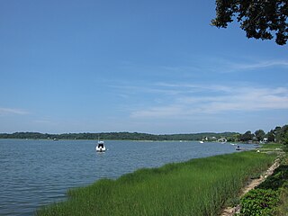
North Sea is a hamlet and census-designated place (CDP) in the Town of Southampton in Suffolk County, on the South Fork of Long Island, in New York, United States. The population was 4,458 at the 2010 census.

<span class="mw-page-title-main">East Kingston, New York</span> CDP in New York, United States

East Kingston is a hamlet in Ulster County, New York, United States. The population was 277 at the 2020 census.

<span class="mw-page-title-main">Lake Katrine, New York</span> CDP in New York, United States

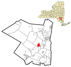
Lake Katrine is a hamlet in Ulster County, New York, United States. The population was 2,522 at the 2020 census.

<span class="mw-page-title-main">Napanoch, New York</span> CDP in New York, United States

Napanoch is a hamlet in Ulster County, New York, United States. It is at the junction of routes 209 and 55. The population was 1,131 at the 2020 census. Napanoch is on the Shawangunk Ridge National Scenic Byway, and is part of the Hudson River Valley National Heritage Area.

<span class="mw-page-title-main">Tillson, New York</span> CDP in New York, United States

Tillson is a hamlet in Ulster County, New York, United States. The population was 1,516 at the 2020 census.

<span class="mw-page-title-main">Walker Valley, New York</span> CDP in New York, United States

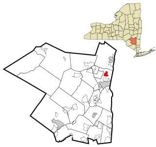
Walker Valley is a hamlet located in the western part of the Town of Shawangunk in Ulster County, New York, United States, generally thought of as coterminous with the 12588 ZIP code. The population was 1,269 at the 2020 census.

<span class="mw-page-title-main">Huber Ridge, Ohio</span> Census-designated place in Ohio, United States

Huber Ridge is a census-designated place (CDP) in Blendon Township, Franklin County, Ohio, United States. The population was 4,940 at the 2020 census.

Spring Ridge is a census-designated place (CDP) in Spring Township, Berks County, Pennsylvania, United States. The population was 1,003 at the 2010 census.

<span class="mw-page-title-main">Meridian, Pennsylvania</span> Census-designated place in Pennsylvania, United States

Meridian is a census-designated place (CDP) in Butler County, Pennsylvania, United States. The population was 3,881 at the 2010 census.

<span class="mw-page-title-main">Village Green-Green Ridge, Pennsylvania</span> Census-designated place in Pennsylvania, United States

Village Green-Green Ridge is a census-designated place (CDP) in Delaware County, Pennsylvania, United States. The population was 7,822 at the 2010 census, down from 8,279 at the 2000 census.

<span class="mw-page-title-main">East Berwick, Pennsylvania</span> Census-designated place in Pennsylvania, United States

East Berwick is a census-designated place (CDP) in Salem Township, Luzerne County, Pennsylvania, United States. The population was 2,007 at the 2010 census.

Littleton is a census-designated place (CDP) and the main village in the town of Littleton in Grafton County, New Hampshire, United States. The population of the CDP was 4,467 at the 2020 census, out of 6,005 in the entire town.

Norridgewock is a census-designated place (CDP) in the town of Norridgewock in Somerset County, Maine, United States. The population was 1,351 at the 2020 census.

References

  1. "ArcGIS REST Services Directory". United States Census Bureau. Retrieved September 20, 2022.
  2. "National Register Information System". National Register of Historic Places . National Park Service. July 9, 2010.
  3. "US Gazetteer files: 2010, 2000, and 1990". United States Census Bureau. February 12, 2011. Retrieved April 23, 2011.
  4. "Census of Population and Housing". Census.gov. Retrieved June 4, 2016.
  5. "U.S. Census website". United States Census Bureau . Retrieved January 31, 2008.
  6. High Meadow School
  7. "Nebraska threads woven into red carpet". Omaha.com. Retrieved January 18, 2011.[ permanent dead link ]