Marlborough, New York

Last updated

Marlborough, New York
Ulster County New York incorporated and unincorporated areas Marlborough highlighted.svg
Location in Ulster County and the state of New York.
Coordinates: 41°37′55″N73°59′3″W / 41.63194°N 73.98417°W / 41.63194; -73.98417
Country United States
State New York
County Ulster
Area
[1]
  Total26.50 sq mi (68.63 km2)
  Land24.47 sq mi (63.38 km2)
  Water2.03 sq mi (5.26 km2)
Elevation
515 ft (157 m)
Population
 (2020)
  Total8,712
  Density330/sq mi (130/km2)
Time zone UTC-5 (Eastern (EST))
  Summer (DST) UTC-4 (EDT)
ZIP code
12542
Area code 845
FIPS code 36-45722
GNIS feature ID0979200

Marlborough is a town in Ulster County, New York, United States, in the southeastern corner of the county. The population was 8,712 at the 2020 census. [2] U.S. Route 9W passes through the eastern part of the town. US Route 44 and NY 55 cross the northwestern corner of the town. The town was named after the Duke of Marlborough.

Contents

History

A land grant (patent) of the territory was made to Captain John Evans of the Royal Navy in 1694. One of his first settlers arrived in 1697.

Perspective map of Marlborough from 1891 with list of landmarks published by L.R. Burleigh Marlborough, N.Y. LOC 2003630236.tif
Perspective map of Marlborough from 1891 with list of landmarks published by L.R. Burleigh

The region was part of the Newburgh Precinct and was set apart in 1772. The Town of Marlborough was formed in 1788 during a period of town formation in the county. Part of the town was used to create the town of Plattekill in 1800.

Geography

According to the United States Census Bureau, the town has a total area of 26.5 square miles (69 km2), of which 24.8 square miles (64 km2) is land and 1.7 square miles (4.4 km2) (6.3%) is water.

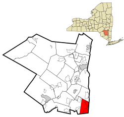
The eastern town line, marked by the Hudson River is the border of Dutchess County, and the southern town line is the border of Orange County. The western border of the town closely parallels the Marlboro Mountain ridge, dividing Marlborough from the town of Plattekill.

The lowest point in the town is the shore of the Hudson River, which is at sea level. The highest point is the summit of Marlboro Mountain, at 1,127 feet (344 m).

Demographics

Historical population
CensusPop.Note
1790 2,241
1820 2,248
1830 2,2721.1%
1840 2,52311.0%
1850 2,406−4.6%
1860 2,77615.4%
1870 2,9757.2%
1880 3,47216.7%
1890 3,5983.6%
1900 3,97810.6%
1910 3,841−3.4%
1920 3,274−14.8%
1930 3,62710.8%
1940 3,7944.6%
1950 4,0035.5%
1960 4,86321.5%
1970 5,65716.3%
1980 7,05524.7%
1990 7,4305.3%
2000 8,26311.2%
2010 8,8086.6%
2020 8,712−1.1%
U.S. Decennial Census [3] 2020 [4]

As of the census [5] of 2000, there were 8,263 people, 3,020 households, and 2,144 families residing in the town. The population density was 332.8 inhabitants per square mile (128.5/km2). There were 3,176 housing units at an average density of 127.9 per square mile (49.4/km2). The racial makeup of the town was 94.48% white, 2.82% African American, .19% Native American, .33% Asian, .01% Pacific Islander, .84% from other races, and 1.33% from two or more races. Hispanic or Latino of any race were 3.98% of the population.

There were 3,020 households, out of which 36.0% had children under the age of 18 living with them, 57.1% were married couples living together, 9.5% had a female householder with no husband present, and 29% were non-families. 22.6% of all households were made up of individuals, and 9.1% had someone living alone who was 65 years of age or older. The average household size was 2.73 and the average family size was 3.25.

In the town, the population was spread out, with 26.5% under the age of 18, 7.4% from 18 to 24, 30.8% from 25 to 44, 23.5% from 45 to 64, and 11.7% who were 65 years of age or older. The median age was 37 years. For every 100 females, there were 96.8 males. For every 100 females age 18 and over, there were 94.8 males.

The median income for a household in the town was $49,788, and the median income for a family was $56,933. Males had a median income of $38,074 versus $29,608 for females. The per capita income for the town was $21,079. About 5.8% of families and 8.2% of the population were below the poverty line, including 8.9% of those under age 18 and 9.5% of those age 65 or over.

Communities and locations in Marlborough

Related Research Articles

<span class="mw-page-title-main">New Baltimore, New York</span> Town in New York, United States

New Baltimore is a town in the northeastern part of Greene County, New York, United States. The population was 3,226 at the 2020 United States census, down from 3,370 in the 2010 census.

<span class="mw-page-title-main">Lattingtown, New York</span> Village in New York, United States

Lattingtown is a village located within the Town of Oyster Bay in Nassau County, on Long Island, in New York, United States. The population was 1,881 at the 2020 census.

<span class="mw-page-title-main">Fort Montgomery, New York</span> CDP in New York, United States

Fort Montgomery is a hamlet in Orange County, New York, United States. The population was 1,627 at the 2020 census. It is part of the Poughkeepsie–Newburgh–Middletown, NY Metropolitan Statistical Area as well as the larger New York–Newark–Bridgeport, NY-NJ-CT-PA Combined Statistical Area.

<span class="mw-page-title-main">West Haverstraw, New York</span> Village in New York, United States

West Haverstraw is a village incorporated in 1883 in the town of Haverstraw, Rockland County, New York, United States. It is located northwest of Haverstraw village, east of Thiells, south of the hamlet of Stony Point, and west of the Hudson River. The population was 10,165 at the 2010 census. The majority of the hamlet of Garnerville is contained in the village of West Haverstraw.

<span class="mw-page-title-main">Thompson, New York</span> Town in New York, United States

Thompson is a town in the southern part of Sullivan County, New York, United States. The population was 16,550 at the 2020 census. The town is named after William Thompson, an early settler.

<span class="mw-page-title-main">Clintondale, New York</span> CDP in New York, United States

Clintondale is a hamlet in Ulster County, New York, United States. The population was 1,938 at the 2020 census.

<span class="mw-page-title-main">Esopus, New York</span> Town in New York, United States

Esopus is a town in Ulster County, New York, United States. The population was 9,548 at the 2020 census. The town was named after the local indigenous tribe and means "small river" in English. They were one of the Lenape (Delaware) bands, belonging to a people who ranged from western Connecticut through lower New York, western Long Island, and parts of New Jersey and Pennsylvania along the Delaware River. The town is on the west bank of the Hudson River south of the city of Kingston. Its center is in Port Ewen. US Route 9W passes along the eastern side of the town.

<span class="mw-page-title-main">Lloyd, New York</span> Town in New York, United States

Lloyd is a town in Ulster County, New York, United States. The population was 11,133 at the 2020 census. It is part of the New York City combined statistical area.

<span class="mw-page-title-main">Marlboro, New York</span> CDP in New York, United States

Marlboro is a hamlet in Ulster County, New York, United States. The population was 3,669 at the 2020 census. Marlboro is in the southeastern part of the town of Marlborough, located in the southeastern corner of the county.

<span class="mw-page-title-main">Milton, Ulster County, New York</span> CDP and hamlet in New York, United States

Milton is a hamlet in Ulster County, New York, United States. The population was 1,650 at the 2020 census. The locale was named after John Milton, an English poet.

<span class="mw-page-title-main">Port Ewen, New York</span> CDP in New York, United States

Port Ewen is a hamlet in Ulster County, New York, United States. The population was 3,678 at the 2020 census. Port Ewen is in the Town of Esopus, south of Kingston, along U.S. Route 9W.

<span class="mw-page-title-main">Saugerties South, New York</span> CDP in New York, United States

Saugerties South is a hamlet in Ulster County, New York, United States. The population was 2,442 at the 2020 census.

<span class="mw-page-title-main">Coeymans, New York</span> Town in New York, United States

Coeymans is a town in Albany County, New York, United States. The population was 7,256 in the 2020 census, a decline from 7,418 at the 2010 census. The town is named after an early settler, who was the patent-holder for the area. The town is in the southeastern part of the county, south of Albany.

<span class="mw-page-title-main">Catskill (town), New York</span> Town in New York, United States

Catskill is a town in the southeastern section of Greene County, New York, United States. The population was 11,298 at the 2020 census, the largest town in the county. The western part of the town is in the Catskill Park. The town contains a village, also called Catskill. The village of Catskill has a well-defined Main Street. There is a public boat launch on the Hudson River called Dutchman's Landing.

<span class="mw-page-title-main">Haverstraw, New York</span> Town in New York, United States

Haverstraw is a town in Rockland County, New York, United States, located north of the Town of Clarkstown and the Town of Ramapo; east of Orange County; south of the Town of Stony Point; and west of the Hudson River. The town runs from the west to the east border of the county in its northern section. The population was 39,087 at the 2020 census.

<span class="mw-page-title-main">Gouverneur, New York</span> Town in New York, United States

Gouverneur is a town in St. Lawrence County, New York, United States. As of the 2020 census, the population was 6,551. That was down from 7,085 in 2010. The town is named after statesman and landowner Gouverneur Morris.

<span class="mw-page-title-main">Hudson (CDP), Massachusetts</span> Census-designated place in Massachusetts, United States

Hudson is a census-designated place (CDP) comprising the densely developed central part of the town of Hudson in Middlesex County, Massachusetts, United States. The population of the CDP was 15,749 at the 2020 census, out of 20,092 in the entire town.

<span class="mw-page-title-main">Gardiner, New York</span> Town in New York, United States

Gardiner is a town in the south-central part of Ulster County, New York, United States. The population was 5,610 at the 2020 census.

<span class="mw-page-title-main">Plattekill (CDP), New York</span> CDP in New York, United States

Plattekill is a hamlet in Ulster County, New York, United States. The population was 1,296 at the 2020 census. The community, as is the town, is named after a local stream, the Platte Kill.

<span class="mw-page-title-main">Plattekill, New York</span> Place in New York, United States

Plattekill is a town in Ulster County, New York, United States. The population was 10,424 in 2020, a slight decrease from 10,499 at the 2010 census. The name is derived from a stream, the Platte Kill.

References

  1. "2016 U.S. Gazetteer Files". United States Census Bureau. Retrieved July 5, 2017.
  2. US Census Bureau, 2020 Census Report Marlborough, New York QuickFacts https://www.census.gov/quickfacts/marlboroughtownulstercountynewyork
  3. "Census of Population and Housing". Census.gov. Retrieved June 4, 2015.
  4. US Census Bureau, 2020 Census Report Marlborough, New York QuickFacts https://www.census.gov/quickfacts/marlboroughtownulstercountynewyork
  5. "U.S. Census website". United States Census Bureau . Retrieved January 31, 2008.
  6. "National Register of Historic Places". WEEKLY LIST OF ACTIONS TAKEN ON PROPERTIES: 10/18/10 THROUGH 10/22/10. National Park Service. October 29, 2010.