Related Research Articles
Fort Johnson is a village in Montgomery County, New York, United States located on the north side of the Mohawk River in the town of Amsterdam. The population was 490 at the 2010 census.
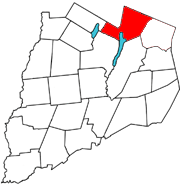
Springfield is a town in Otsego County, New York, United States. The population was 1,358 at the 2010 census.

Mount Ivy is a hamlet and census-designated place in the Town of Haverstraw, in Rockland County, New York, United States. It is located north of New City, east of Pomona, south of Thiells, and west of Garnerville. The population was 6,878 at the 2010 census.
Orangeburg is a hamlet and census-designated place, in the town of Orangetown, Rockland County, New York, United States. It is located north of Tappan, south of Blauvelt, east of Pearl River and west of Piermont. The population was 4,568 at the 2010 census.

Phoenicia is a hamlet of Shandaken in Ulster County, New York, United States. The population was 268 at the 2020 census, making it the second highest populated community in the town. The village center is located just off Route 28 at its junction with Route 214 and is nestled at the base of three peaks, Mount Tremper, Romer Mountain, and Sheridan Mountain. The community sits at the confluence of the Esopus Creek and Stony Clove Creek. A popular getaway for New Yorkers, the hamlet has frequented many tourism guides as among the best vacation towns in the greater New York City area.

Shandaken is a town on the northern border of Ulster County, New York, United States, northwest of Kingston, New York. As of the 2020 census, the town had a total population of 2,866. The name is believed to be from an Esopus phrase for "land of rapid waters."
Mount Morris is a village in the town of Mount Morris in Livingston County, New York, United States. The village population was 2,986 at the 2010 census, out of 4,465 in the entire town. The village and town are named after Robert Morris.
Ohio's 5th congressional district is in northwestern and north central Ohio and borders Indiana. The district is currently represented by Republican Bob Latta.

New York State Route 212 (NY 212) is an east–west state highway located entirely within Ulster County, New York, in the United States. It runs for 21.92 miles (35.28 km) from an intersection with NY 28 in the interior of the Catskill Park to a junction with U.S. Route 9W (US 9W) and NY 32 on the west bank of the Hudson River, providing a key interchange with the New York State Thruway along the way. The mostly rural two-lane route serves the communities of Woodstock and Saugerties while passing Cooper Lake, Kingston's reservoir. NY 212 was assigned as part of the 1930 renumbering of state highways in New York.
Shady is a hamlet in Ulster County, New York, United States. It is part of the town of Woodstock and lies on New York State Route 212.

Lake Lashaway is a 293-acre (1.19 km2) pond located near the East Brookfield and North Brookfield, Massachusetts town line. The Lake Lashaway Community Association’s website is www.LakeLashaway.org. The town line cuts the lake approximately in half. The lake lies just to the north of state Route 9 as it passes through East Brookfield.
The Kaatskill Kaleidoscope is the world's largest kaleidoscope, measuring 56 feet (17 m) in height. It is located in Mount Tremper, New York. It is housed in a converted grain silo. It was designed by 1960s psychedelic artist Isaac Abrams and his son Raphael. It cost $250,000 to build and opened in 1996. Catskills developer Dean Gitter is credited with creating the concept for its construction.
Centerville is a small community in the Town of Saugerties, Ulster County, New York, United States. Centerville is located along New York State Route 212, approximately 2 mi (3.2 km) west of Interstate 87, and several miles east of Catskill State Park. The community is located at 42°08′42″N74°01′31″W.
Boiceville is a hamlet in the town of Olive, Ulster County, New York, United States. Located at the intersection of New York State Route 28 and New York State Route 28A, Boiceville is within Catskill State Park.

Freehold is a hamlet in the town of Greenville in Greene County, New York, United States. It has the ZIP Code 12431, and its own fire district.
Mount Pleasant is a populated place in the town of Shandaken in Ulster County, New York, United States. Mount Pleasant is located along New York State Route 28 within Catskill State Park, to the south of Phoenicia and to the north of Boiceville. The community is located at 42°02′54″N74°17′21″W.
Oliverea is a populated place in Ulster County, New York, United States. It is situated on Esopus Creek along Ulster Country Route 47 within Catskill State Park. The community is located at 42°03′55″N74°27′37″W in the Town of Shandaken.

Wanakah is a hamlet in the town of Hamburg in Erie County, New York, United States. As of the 2010 census, it had a population of 3,199.
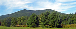
Mount Tremper, officially known as Tremper Mountain and originally called Timothyberg, is one of the Catskill Mountains in the U.S. state of New York. It is located near the hamlet of Phoenicia, in the valley of Esopus Creek.
Worcester is a census-designated place (CDP) forming the central settlement of the town of Worcester in Otsego County, New York, United States. The population of the CDP was 986 at the 2020 census.
References
- ↑ "Mount Tremper, New York". Geographic Names Information System . United States Geological Survey, United States Department of the Interior . Retrieved January 1, 2009.
Municipalities and communities of Ulster County, New York, United States | ||
|---|---|---|
| City |  | |
| Towns | ||
| Villages | ||
| CDPs |
| |
| Other hamlets |
| |
| Footnotes | ‡This populated place also has portions in an adjacent county or counties | |
| | This article about a location in Ulster County, New York is a stub. You can help Wikipedia by expanding it. |