Zena, New York

Last updated

Zena, New York
CDP
Ulster County New York incorporated and unincorporated areas Zena highlighted.svg
Location in Ulster County and the state of New York.
Coordinates: 42°1′20″N74°5′9″W / 42.02222°N 74.08583°W / 42.02222; -74.08583
Country United States
State New York
County Ulster
Area
[1]
  Total3.09 sq mi (8.01 km2)
  Land3.06 sq mi (7.92 km2)
  Water0.03 sq mi (0.09 km2)
Elevation
377 ft (115 m)
Population
 (2020)
  Total1,038
  Density339.55/sq mi (131.08/km2)
Time zone UTC-5 (EST)
  Summer (DST) UTC-4 (EDT)
FIPS code 36-84187 [2]
GNIS feature ID0971869 [3]

Zena is a hamlet (and census-designated place) in Ulster County, New York, United States. As of the 2020 census the population was 1,038.

Contents

Zena is in the Town of Woodstock on County Route 30. The community is northwest of Kingston. Zena is one of the more wealthy areas of this region, with the average home value above $300,000.

Geography

Zena is located at 42°1′20″N74°5′9″W / 42.02222°N 74.08583°W / 42.02222; -74.08583 (42.022311, -74.085908). [4]

According to the United States Census Bureau, the CDP has a total area of 3.0 square miles (7.8 km2), all land.

Zena is bordered on the west by Morey Hill Rd, extends north through Zena Highwoods Rd until Church Rd., also north halfway up John Joy Rd. It extends north on Zena Rd, almost all the way to State Route 212. On the northern end, it also includes the southern half of Chestnut Hill Rd and most of Witchtree Rd.

Demographics

Historical population
CensusPop.Note
2000 1,119
2010 1,031−7.9%
2020 1,0380.7%
U.S. Decennial Census [5]

As of the census [2] of 2000, there were 1,119 people, 447 households, and 320 families residing in the CDP. The population density was 379.8 inhabitants per square mile (146.6/km2). There were 501 housing units at an average density of 170.0 per square mile (65.6/km2). The racial makeup of the CDP was 94.37% White, 1.79% African American, 0.09% Native American, 1.97% Asian, 0.09% Pacific Islander, 0.71% from other races, and 0.98% from two or more races. Hispanic or Latino of any race were 1.52% of the population.

There were 447 households, out of which 28.4% had children under the age of 18 living with them, 60.0% were married couples living together, 8.7% had a female householder with no husband present, and 28.2% were non-families. 21.5% of all households were made up of individuals, and 7.6% had someone living alone who was 65 years of age or older. The average household size was 2.49 and the average family size was 2.93.

In the CDP, the population was spread out, with 22.9% under the age of 18, 3.6% from 18 to 24, 22.8% from 25 to 44, 32.9% from 45 to 64, and 17.9% who were 65 years of age or older. The median age was 45 years. For every 100 females, there were 87.4 males. For every 100 females age 18 and over, there were 90.1 males.

The median income for a household in the CDP was $62,566, and the median income for a family was $80,945. Males had a median income of $48,523 versus $39,500 for females. The per capita income for the CDP was $32,084. About 3.3% of families and 5.9% of the population were below the poverty line, including 10.4% of those under age 18 and 1.5% of those age 65 or over.

Related Research Articles

<span class="mw-page-title-main">Valinda, California</span> Census-designated place in California, United States

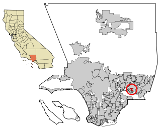
Valinda is a census-designated place (CDP) in the San Gabriel Valley, in Los Angeles County, California, in the United States. At the 2010 census, the population was 22,822, up from 21,776 at the 2000 census.

<span class="mw-page-title-main">Nuevo, California</span> Census-designated place in California, United States

Nuevo is a rural community located east of Lake Perris and the city of Perris in Riverside County, California. The population of the census-designated place (CDP) is 7,033 according to the 2020 census, up from 6,447 at the 2010 census.

<span class="mw-page-title-main">Bellair-Meadowbrook Terrace, Florida</span> Census-designated place in Florida, United States

Bellair-Meadowbrook Terrace is an unincorporated area and census-designated place (CDP) in Clay County, Florida, United States. The population was 13,343 at the 2010 census.

<span class="mw-page-title-main">Lakeland Village, California</span> Census-designated place in California, United States

Lakeland Village is a census-designated place (CDP) in Riverside County, California, United States. The population was 11,541 at the 2010 census, more than double the 5,626 reported at the 2000 census.

<span class="mw-page-title-main">Kremlin, Montana</span> Census-designated place in Montana, United States

Kremlin is an unincorporated community and census-designated place (CDP) in Hill County, Montana, United States. The population was 98 at the 2010 census, down from 126 in 2000.

<span class="mw-page-title-main">Lolo, Montana</span> CDP in Montana, United States

Lolo is a census-designated place (CDP) in Missoula County, Montana, United States. It is part of the Missoula Metropolitan Statistical Area. The population was 4,399 at the 2020 census, an increase from its population of 3,892 in 2010. It is home to Travelers' Rest State Park, a site where Lewis and Clark camped in 1805 and again in 1806.

<span class="mw-page-title-main">Whittingham, New Jersey</span> Populated place in Middlesex County, New Jersey, US

Whittingham, also known as Greenbriar at Whittingham, is an unincorporated community and census-designated place (CDP) located within Monroe Township, in Middlesex County, in the U.S. state of New Jersey. As of the 2010 United States Census, the CDP's population was 2,476. The area is focused around the age-restricted gated community of Whittingham.

<span class="mw-page-title-main">Preston-Potter Hollow, New York</span> Census-designated place in New York, United States

Preston-Potter Hollow is a census-designated place (CDP) in Albany County, New York, United States. The population was 366 at the 2010 census.

<span class="mw-page-title-main">Parc, New York</span> Census-designated place in New York, United States

Parc is a location and census-designated place in Clinton County, New York, United States. The name "Parc" is derived from the official name for the 3,447-acre (13.95 km2) industrial site, which is PARC, an acronym for the Plattsburgh Airbase Redevelopment Corporation. PARC was established for the purpose of redeveloping the Plattsburgh Air Force Base after it closed on September 25, 1995. PARC is now operated by the Plattsburgh Air Base Development Authority, and the massive airfield is now Plattsburgh International Airport. The population of the Parc CDP was 254 at the 2010 census. Parc is located in the town of Plattsburgh and is bordered to the north by the city of Plattsburgh.

<span class="mw-page-title-main">Mount Ivy, New York</span> Census-designated place in New York, United States

Mount Ivy is a hamlet and census-designated place in the Town of Haverstraw, in Rockland County, New York, United States. It is located north of New City, east of Pomona, south of Thiells, and west of Garnerville. The population was 6,878 at the 2010 census.

<span class="mw-page-title-main">South Hill, New York</span> CDP in New York, United States

South Hill is a census-designated place (CDP) in Tompkins County, New York, United States. The population was 7,245 at the 2020 census.

<span class="mw-page-title-main">West Hurley, New York</span> CDP in New York, United States

West Hurley is a hamlet in Ulster County, New York, United States. The population was 1,917 at the 2020 census.

<span class="mw-page-title-main">Zena, Oklahoma</span> CDP in Oklahoma, United States

Zena is a census-designated place (CDP) in Delaware County, Oklahoma, United States, along State Highway 127. The population was 122 at the 2010 census. Established on Courthouse Prairie in District 5 of the old Indian Territory, its post office existed from April 11, 1896, until January 31, 1956. It is said to have been named for Asenith Wood, the wife of the first postmaster.

Eastlawn Gardens is a census-designated place (CDP) in Upper Nazareth Township in Northampton County, Pennsylvania. The population of Eastlawn Gardens was 3,307 at the 2010 census. Eastlawn Gardens is part of the Lehigh Valley metropolitan area, which had a population of 861,899 and was the 68th-most populous metropolitan area in the U.S. as of the 2020 census.

<span class="mw-page-title-main">Verlot, Washington</span> CDP in Washington, United States

Verlot is a census-designated place (CDP) in Snohomish County, Washington, United States. The population was 285 at the 2010 census.

<span class="mw-page-title-main">Chugcreek, Wyoming</span> CDP in Wyoming, United States

Chugcreek is a census-designated place (CDP) in Platte County, Wyoming, United States. The population was 156 at the 2010 census.

<span class="mw-page-title-main">Milford (CDP), Massachusetts</span> CDP in Massachusetts, United States

Milford is a census-designated place (CDP) in the town of Milford in Worcester County, Massachusetts, United States. The population was 25,055 at the 2010 census.

<span class="mw-page-title-main">Sturbridge (CDP), Massachusetts</span> CDP in Massachusetts, United States

Sturbridge is a census-designated place (CDP) in the town of Sturbridge in Worcester County, Massachusetts, United States. The population was 2,253 at the 2010 census.

<span class="mw-page-title-main">Woodstock (CDP), New York</span> CDP in New York, United States

Woodstock is a hamlet in Ulster County, New York, United States. The population was 2,088 according to the 2010 census. The community of Woodstock is in the eastern part of the Town of Woodstock and is northwest of Kingston. It is located along NY 212 near its junction with NY 375. Although the name of the community and the town lent its name to the Woodstock Festival, that event did not take place in Woodstock.

Andrews Air Force Base is a census-designated place (CDP) covering the residential population of Andrews Air Force Base/Joint Base Andrews, in Prince George's County, Maryland, Maryland, United States. The population at the 2020 Census was 3,025.

References

  1. "ArcGIS REST Services Directory". United States Census Bureau. Retrieved September 20, 2022.
  2. 1 2 "U.S. Census website". United States Census Bureau . Retrieved January 31, 2008.
  3. "US Board on Geographic Names". United States Geological Survey. October 25, 2007. Retrieved January 31, 2008.
  4. "US Gazetteer files: 2010, 2000, and 1990". United States Census Bureau. February 12, 2011. Retrieved April 23, 2011.
  5. "Census of Population and Housing". Census.gov. Retrieved June 4, 2016.