Gardiner (CDP), New York

Last updated
Gardiner, New York
CDP
Gardiner, New York.jpg
Downtown Gardiner
Ulster County New York incorporated and unincorporated areas Gardiner (CDP) highlighted.svg
Location in Ulster County and the state of New York.
Coordinates: 41°40′48″N74°9′4″W / 41.68000°N 74.15111°W / 41.68000; -74.15111 Coordinates: 41°40′48″N74°9′4″W / 41.68000°N 74.15111°W / 41.68000; -74.15111
Country United States
State New York
County Ulster
Area
[1]
  Total3.86 sq mi (10.00 km2)
  Land3.86 sq mi (10.00 km2)
  Water0.00 sq mi (0.00 km2)
Elevation
315 ft (96 m)
Population
 (2020)
  Total952
  Density246.44/sq mi (95.16/km2)
Time zone UTC-5 (Eastern (EST))
  Summer (DST) UTC-4 (EDT)
ZIP code
12525
Area code 845
FIPS code 36-28244
GNIS feature ID0950882

Gardiner is a hamlet (and a census-designated place) in Ulster County, New York, United States. The population was 950 at the 2010 census.

Contents

The community is near the center of the Town of Gardiner on routes 44 and 55.

Geography

Gardiner is located at 41°40′48″N74°09′04″W / 41.680114°N 74.151143°W / 41.680114; -74.151143 (41.680114, -74.151143). [2]

According to the United States Census Bureau, the CDP has a total area of 3.8 square miles (9.9 km2). None of the area is covered with water.

Demographics

Historical population
CensusPop.
2020 952
U.S. Decennial Census [3]

As of the census [4] of 2000, there were 856 people, 342 households, and 234 families residing in the CDP. The population density was 223.8 per square mile (86.5/km2). There were 371 housing units at an average density of 97.0/sq mi (37.5/km2). The racial makeup of the CDP was 96.85% White, 0.23% Native American, 0.58% Asian, 0.12% Pacific Islander, 1.05% from other races, and 1.17% from two or more races. Hispanic or Latino of any race were 4.56% of the population.

There were 342 households, out of which 31.9% had children under the age of 18 living with them, 55.6% were married couples living together, 8.5% had a female householder with no husband present, and 31.3% were non-families. 23.7% of all households were made up of individuals, and 6.7% had someone living alone who was 65 years of age or older. The average household size was 2.50 and the average family size was 2.95.

In the CDP, the population was spread out, with 23.7% under the age of 18, 7.2% from 18 to 24, 32.6% from 25 to 44, 25.5% from 45 to 64, and 11.0% who were 65 years of age or older. The median age was 37 years. For every 100 females, there were 95.9 males. For every 100 females age 18 and over, there were 98.5 males.

The median income for a household in the CDP was $48,365, and the median income for a family was $49,808. Males had a median income of $35,583 versus $23,281 for females. The per capita income for the CDP was $22,653. About 9.5% of families and 11.7% of the population were below the poverty line, including 24.0% of those under age 18 and 9.0% of those age 65 or over.

Related Research Articles

<span class="mw-page-title-main">South Dos Palos, California</span> Census-designated place in California, US

South Dos Palos is a census-designated place (CDP) in Merced County, California, United States. South Dos Palos is located 2 miles (3.2 km) southwest of Dos Palos, at an elevation of 118 feet. The population was 1,620 at the 2010 census, up from 1,385 at the 2000 census.

<span class="mw-page-title-main">Greentree, New Jersey</span> Census-designated place in New Jersey, United States

Greentree is an unincorporated community and census-designated place (CDP) located within Cherry Hill Township, in Camden County, New Jersey, United States. As of the 2010 United States Census, the CDP's population was 11,367.

<span class="mw-page-title-main">Olivet, New Jersey</span> Census-designated place in New Jersey, United States

Olivet is an unincorporated community and census-designated place (CDP) located within Pittsgrove Township, in Salem County, New Jersey, United States. As of the 2010 United States Census, the CDP's population was 1,408.

<span class="mw-page-title-main">Firthcliffe, New York</span> CDP in New York, United States

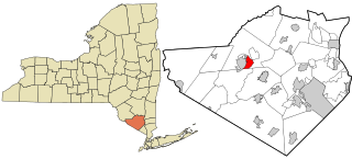
Firthcliffe is a hamlet in Orange County, New York United States. The population was 4,949 at the 2010 census. It is part of the Poughkeepsie–Newburgh–Middletown, NY Metropolitan Statistical Area as well as the larger New York–Newark–Bridgeport, NY-NJ-CT-PA Combined Statistical Area.

<span class="mw-page-title-main">Mechanicstown, New York</span> CDP in New York, United States

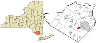
Mechanicstown is a hamlet in Orange County, New York, United States. The population was 6,061 at the 2000 census and 6,858 as of the 2010 census. It is part of the Poughkeepsie–Newburgh–Middletown, NY Metropolitan Statistical Area as well as the larger New York–Newark–Bridgeport, NY-NJ-CT-PA Combined Statistical Area.

<span class="mw-page-title-main">Walton Park, New York</span> CDP in New York, United States

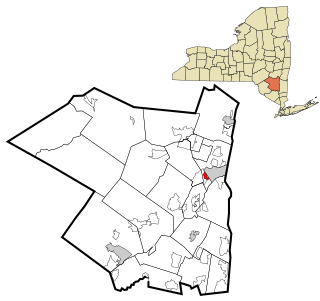
Walton Park is a census-designated place (CDP) in Orange County, New York, United States. As of the 2010 census, the CDP had a total population of 2,669.

<span class="mw-page-title-main">Washington Heights, New York</span> CDP in New York, United States

Washington Heights is a census-designated place (CDP) in Orange County, New York, United States. The population was 2,205 at the 2020 census.

<span class="mw-page-title-main">Clintondale, New York</span> CDP in New York, United States

Clintondale is a hamlet in Ulster County, New York, United States. The population was 1,452 at the 2010 census.

<span class="mw-page-title-main">Hillside, New York</span> CDP in New York, United States

Hillside is a census-designated place (CDP) in Ulster County, New York, United States. The population was 877 at the 2010 census.

<span class="mw-page-title-main">Tillson, New York</span> CDP in New York, United States

Tillson is a hamlet in Ulster County, New York, United States. The population was 1,586 at the 2010 census.

<span class="mw-page-title-main">Woodside, Pennsylvania</span> Census-designated place in Pennsylvania, United States

Woodside is a census-designated place (CDP) in Bucks County, Pennsylvania, United States. The population was 2,425 at the 2010 census.

<span class="mw-page-title-main">Hyde, Pennsylvania</span> Census-designated place in Pennsylvania, United States

Hyde is an unincorporated community and census-designated place (CDP) in Clearfield County, Pennsylvania, United States. The population was 1,303 at the 2020 census.

<span class="mw-page-title-main">Castanea, Pennsylvania</span> Census-designated place in Pennsylvania, United States

Castanea is a census-designated place (CDP) in Castanea Township, Clinton County, Pennsylvania, United States. The population was 1,125 at the 2010 census.

<span class="mw-page-title-main">Guys Mills, Pennsylvania</span> Census-designated place in Pennsylvania, United States

Guys Mills is a census-designated place in Crawford County, Pennsylvania, United States. The population was 124 at the 2010 census.

<span class="mw-page-title-main">Pymatuning South, Pennsylvania</span> Census-designated place in Pennsylvania, United States

Pymatuning South is a census-designated place (CDP) in Crawford County, Pennsylvania, United States. The population was 479 at the 2010 census.

<span class="mw-page-title-main">Lawnton, Pennsylvania</span> Census-designated place in Pennsylvania, United States

Lawnton is an unincorporated area and census-designated place (CDP) in Swatara Township, Dauphin County, Pennsylvania, United States. The population was 3,813 at the 2010 census. It is part of the Harrisburg–Carlisle Metropolitan Statistical Area.

<span class="mw-page-title-main">Slater, Wyoming</span> CDP in Wyoming, United States

Slater is a census-designated place (CDP) in Platte County, Wyoming, United States. The population was 80 at the 2010 census.

<span class="mw-page-title-main">Walpole (CDP), Massachusetts</span> CDP in Massachusetts, United States

Walpole is a small census-designated place (CDP) located within the much larger town of Walpole in Norfolk County, Massachusetts, United States. Walpole Town as it is called by the US Census Bureau, also includes a much larger population. The population of the Census Designated Place was 5,918 at the 2010 census.

<span class="mw-page-title-main">Marshfield (CDP), Massachusetts</span> Census-designated place in Massachusetts, United States

Marshfield is a census-designated place (CDP) in the town of Marshfield in Plymouth County, Massachusetts, United States. The population was 4,335 at the 2010 census.

<span class="mw-page-title-main">Plattekill (CDP), New York</span> CDP in New York, United States

Plattekill is a hamlet in Ulster County, New York, United States. The population was 1,260 at the 2010 census. The community, as is the town, is named after a local stream, the Platte Kill.

References

  1. "ArcGIS REST Services Directory". United States Census Bureau. Retrieved September 20, 2022.
  2. "US Gazetteer files: 2010, 2000, and 1990". United States Census Bureau. 2011-02-12. Retrieved 2011-04-23.
  3. "Census of Population and Housing". Census.gov. Retrieved June 4, 2016.
  4. "U.S. Census website". United States Census Bureau . Retrieved 2008-01-31.