Woodstock (CDP), New York

Last updated

Woodstock, New York
CDP
Woodstock-city-ny.gif
U.S. Census Map
Ulster County New York incorporated and unincorporated areas Woodstock (CDP) highlighted.svg
Location in Ulster County and the state of New York.
Coordinates: 42°2′25″N74°7′2″W / 42.04028°N 74.11722°W / 42.04028; -74.11722
Country United States
State New York
County Ulster
Area
[1]
  Total6.85 sq mi (17.75 km2)
  Land6.84 sq mi (17.73 km2)
  Water0.01 sq mi (0.02 km2)
Elevation
561 ft (171 m)
Population
 (2020)
  Total2,521
  Density368.35/sq mi (142.22/km2)
Time zone UTC-5 (Eastern (EST))
  Summer (DST) UTC-4 (EDT)
ZIP code
12498
Area code 845
FIPS code 36-83041 [2]
GNIS feature ID0971721 [3]

Woodstock is a hamlet (and census-designated place) in Ulster County, New York, United States. The population was 2,088 according to the 2010 census. The community of Woodstock is in the eastern part of the Town of Woodstock and is northwest of Kingston. It is located along NY 212 near its junction with NY 375. Although the name of the community and the town lent its name to the Woodstock Festival, that event did not take place in Woodstock.

Contents

Geography

Woodstock is located at 42°2′24″N74°7′2″W / 42.04000°N 74.11722°W / 42.04000; -74.11722 (42.040269, -74.117258). [4]

According to the United States Census Bureau, the CDP has a total area of 5.9 square miles (15.3 km2), of which 5.9 square miles (15.3 km2) is land and 0.17% is water.

Demographics

Historical population
CensusPop.Note
2020 2,521
U.S. Decennial Census [5]

As of the census [2] of 2000, there were 2,187 people, 1,124 households, and 528 families residing in the CDP. The population density was 370.3 inhabitants per square mile (143.0/km2). There were 1,385 housing units at an average density of 234.5 per square mile (90.5/km2). The racial makeup of the CDP was 93.23% White, 1.55% Black or African American, 0.23% Native American, 1.78% Asian, 0.64% from other races, and 2.56% from two or more races. Hispanic or Latino of any race were 3.89% of the population.

There were 1,124 households, out of which 19.6% had children under the age of 18 living with them, 35.1% were married couples living together, 9.1% had a female householder with no husband present, and 53.0% were non-families. 43.4% of all households were made up of individuals, and 14.1% had someone living alone who was 65 years of age or older. The average household size was 1.94 and the average family size was 2.64.

In the CDP, the population was spread out, with 16.9% under the age of 18, 5.0% from 18 to 24, 23.4% from 25 to 44, 36.0% from 45 to 64, and 18.7% who were 65 years of age or older. The median age was 48 years. For every 100 females, there were 90.0 males. For every 100 females age 18 and over, there were 87.4 males.

The median income for a household in the CDP was $38,594, and the median income for a family was $46,467. Males had a median income of $31,000 versus $30,357 for females. The per capita income for the CDP was $28,478. About 7.5% of families and 11.9% of the population were below the poverty line, including 15.7% of those under age 18 and 4.9% of those age 65 or over.

Related Research Articles

<span class="mw-page-title-main">Morada, California</span> Census-designated place in California, United States

Morada is a census-designated place (CDP) in San Joaquin County, California, United States. The population was 3,166 at the 2020 census, down from 3,828 at the 2010 census.

<span class="mw-page-title-main">Bel Air South, Maryland</span> Census-designated place in Maryland, United States

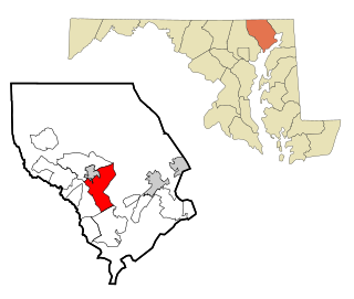
Bel Air South is a census-designated place (CDP) in Harford County, Maryland, United States. The population was 47,709 at the 2010 census, up from 39,711 in 2000.

<span class="mw-page-title-main">Woodstock Township, Michigan</span> Civil township in Michigan, United States

Woodstock Township is a civil township of Lenawee County, Michigan, United States. As of the 2000 census, the township population was 3,468.

<span class="mw-page-title-main">South Woodstock, Connecticut</span> Census-designated place in Connecticut, United States

South Woodstock is a village and census-designated place (CDP) in Woodstock, Windham County, Connecticut, United States. The population was 1,291 at the 2010 census.

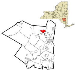
Tribes Hill is a census-designated place (CDP) located in the Towns of Mohawk (80%) and Amsterdam (20%) in Montgomery County, New York, United States. The population was 1,003 at the 2010 census. One theory is the name is based on this location having been a gathering spot for the Mohawk nation, the dominant Iroquois tribe in the area during colonial times. People who live here are referred to as “Tribes Hillbillies”.

<span class="mw-page-title-main">Scotchtown, New York</span> Hamlet and CDP in New York, United States

Scotchtown is a hamlet in the Town of Wallkill, in Orange County, New York, United States. The population was 10,578 at the 2020 census. It has the ZIP Code 10941. The hamlet is located east of the City of Middletown. It is part of the Poughkeepsie–Newburgh–Middletown, NY Metropolitan Statistical Area as well as the larger New York–Newark–Bridgeport, NY-NJ-CT-PA Combined Statistical Area.

<span class="mw-page-title-main">Washington Heights, New York</span> CDP in New York, United States

Washington Heights is a census-designated place (CDP) in Orange County, New York, United States. The population was 2,205 at the 2020 census.

<span class="mw-page-title-main">Duane Lake, New York</span> Census-designated place in New York, United States

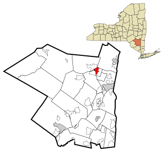
Duane Lake is a census-designated place (CDP) in Schenectady County, New York, United States. The population was 323 at the 2010 census.

<span class="mw-page-title-main">Mariaville Lake, New York</span> Census-designated place in New York, United States

Mariaville Lake is a census-designated place (CDP) in Schenectady County, New York. The population was 722 at the 2010 census.

<span class="mw-page-title-main">West Hurley, New York</span> CDP in New York, United States

West Hurley is a hamlet in Ulster County, New York, United States. The population was 1,917 at the 2020 census.

<span class="mw-page-title-main">Zena, New York</span> CDP in New York, United States

Zena is a hamlet in Ulster County, New York, United States. As of the 2020 census the population was 1,038.

<span class="mw-page-title-main">Summerside, Ohio</span> Census-designated place in Ohio, United States

Summerside is a census-designated place (CDP) in Union Township, Clermont County, Ohio, United States. Its population was 4,941 as of the 2020 census.

<span class="mw-page-title-main">Woodside, Pennsylvania</span> Census-designated place in Pennsylvania, United States

Woodside is a census-designated place (CDP) in Bucks County, Pennsylvania, United States. The population was 2,425 at the 2010 census.

<span class="mw-page-title-main">Mountainhome, Pennsylvania</span> Census-designated place in Pennsylvania, United States

Mountainhome is a census-designated place (CDP) in Barrett Township, Monroe County, Pennsylvania, United States. The population was 1,182 at the 2010 census.

<span class="mw-page-title-main">Madison Heights, Virginia</span> CDP in Virginia, United States

Madison Heights is a census-designated place (CDP) in Amherst County, Virginia, United States. The population was 10,893 at the 2020 census. It is part of the Lynchburg Metropolitan Statistical Area.

<span class="mw-page-title-main">Rowley (CDP), Massachusetts</span> Census-designated place in Massachusetts, United States

Rowley is a census-designated place (CDP) in the town of Rowley in Essex County, Massachusetts, United States. The population was 1,416 at the 2010 census.

<span class="mw-page-title-main">Tonawanda (CDP), New York</span> Census-designated place in New York, United States

Tonawanda is a census-designated place (CDP) in Erie County, New York, United States. The CDP comprises the town of Tonawanda minus its subsidiary village of Kenmore. As of the 2010 census, the CDP population was 58,144.

Cairo is a hamlet and census-designated place (CDP) in the town of Cairo in Greene County, New York, United States. The population of the CDP was 1,402 at the 2010 census, out of 6,610 people in the entire town.

Greenville is a hamlet and census-designated place (CDP) in the town of Greenville, in Greene County, New York, United States. The population of the CDP was 688 at the 2010 census, out of a total 3,739 people in the town as a whole.

<span class="mw-page-title-main">North Woodstock, New Hampshire</span> Census-designated place in New Hampshire, United States

North Woodstock is a census-designated place (CDP) and the primary village in the town of Woodstock in Grafton County, New Hampshire, United States. It had a population of 739 at the 2020 census.

References

  1. "ArcGIS REST Services Directory". United States Census Bureau. Retrieved September 20, 2022.
  2. 1 2 "U.S. Census website". United States Census Bureau . Retrieved January 31, 2008.
  3. "US Board on Geographic Names". United States Geological Survey. October 25, 2007. Retrieved January 31, 2008.
  4. "US Gazetteer files: 2010, 2000, and 1990". United States Census Bureau. February 12, 2011. Retrieved April 23, 2011.
  5. "Census of Population and Housing". Census.gov. Retrieved June 4, 2016.