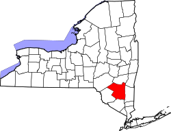
Krumville (also Kromville) is a hamlet in the southeastern corner of the town of Olive in Ulster County, New York, United States. It takes its name from one of the most prominent of the early Dutch families who settled the area. Krumville is bordered on the northwest by the Olive hamlet of Samsonville, on the north by the hamlet of Olivebridge, on the southeast by the town of Marbletown and on the southwest by the town of Rochester. It lies at an elevation of 774 feet (236 m) above sea level.
The major commercial business in Krumville is the Country Inn, [1] a bed-and-breakfast/restaurant in what was once known as the Deer Park Falls House, a long-time boarding house and inn. The Deer Park (or Deerhaven) is a long, low gorge that drains into Beaver Lake and Beaverdam Creek below the Deer Park Falls. [2] The center of the hamlet is the intersection of Ulster County Route 2, which connects Kripplebush and Samsonville, and County Route 2A, also known as the Krumville Road or Krumville-Davis Corners Road. The Krumville Reformed Church was located nearby. The building was originally located in Samsonville but was taken down and rebuilt in Krumville in 1873. [3] That church burned down in 1946. The former Krumville schoolhouse was converted into a replacement church dedicated in 1955. [4] The church conducted its final service in 2011. [5]
Krumville once had its own Post Office but now shares the ZIP code 12461 with neighboring Olivebridge. The U.S. Postal Service recognizes Krumville as a valid address within that ZIP. [6]
Krumville is mentioned in Spalding Gray's Swimming to Cambodia and Terrors of Pleasure . It also is the song title of one of the tracks on Oneohtrix Point Never's 2023 album Again .
Ulster County is a county in the U.S. state of New York. It is situated along the Hudson River. As of the 2020 census, the population was 181,851. The county seat is Kingston. The county is named after the Irish province of Ulster.
Middletown is the largest city in Orange County, New York, United States. It lies in New York's Hudson Valley region, near the Wallkill River and the foothills of the Shawangunk Mountains. Middletown is situated between Port Jervis and Newburgh, New York. At the 2020 United States census, the city's population was 30,345, reflecting an increase of 2,259 from the 28,086 counted in the 2010 census. The zip code is 10940. Middletown falls within the Kiryas Joel–Poughkeepsie–Newburgh Metropolitan Statistical Area, which belongs to the larger New York–Newark–Bridgeport, NY–NJ–CT–PA Combined Statistical Area.
Pine Bush is a hamlet located in the town of Crawford and adjacent to Shawangunk, New York, within Orange and adjacent to Ulster counties in the U.S. It is roughly coterminous with the 12566 ZIP code and 744 telephone exchange in the 845 area code. These both extend into adjacent regions of the town of Shawangunk in Ulster County.. The population was 1,751 at the 2020 census.
Fayette is a town in Seneca County, New York, United States. The population was 3,617 at the 2020 census. The town is in the north-central part of the county and is southeast of Geneva, New York.
Esopus is a town in Ulster County, New York, United States. The population was 9,548 at the 2020 census. The town was named after the local indigenous tribe and means "small river" in English. They were one of the Lenape (Delaware) bands, belonging to a people who ranged from western Connecticut through lower New York, western Long Island, and parts of New Jersey and Pennsylvania along the Delaware River. The town is on the west bank of the Hudson River south of the city of Kingston. Its center is in Port Ewen. US Route 9W passes along the eastern side of the town.
Kerhonkson is a hamlet and census-designated place (CDP) in Ulster County, New York, United States. The population was 1,722 at the 2020 census.
Olive is a town in Ulster County, New York, United States. The town is west of Kingston, New York and is inside the Catskill Park. The population was 4,226 at the 2020 census.
Area codes 845 and 329 are telephone area codes in the North American Numbering Plan (NANP) for the U.S. state of New York. The numbering plan area comprises the mid- and lower Hudson Valley, specifically Orange, Putnam, Rockland, and Ulster counties, and parts of Columbia, Delaware, Dutchess, Greene, and Sullivan counties.
New York State Route 28A (NY 28A) is an east–west state highway in Ulster County, New York, in the United States. It extends for nearly 20 miles (32 km) along the south side of Ashokan Reservoir in Catskill Park, serving as a southerly alternate route of NY 28 through the area. Many of the communities along its length, such as West Shokan and Olivebridge, are relocated versions of those condemned for the reservoir's construction. Near Olivebridge, NY 28A intersects NY 213, the only other state route that NY 28A intersects aside from its parent, NY 28.
New York State Route 213 (NY 213) is a state highway located entirely in Ulster County. It runs from the eastern Catskills to downtown Kingston.
Palentown is a hamlet in Ulster County, New York, United States.
Olivebridge is a hamlet in the town of Olive, Ulster County, New York, United States, within Catskill Park and the Catskill Mountains.
The Wallkill Valley Rail Trail is a 23.7-mile (38.1 km) rail trail and linear park that runs along the former Wallkill Valley Railroad rail corridor in Ulster County, New York, United States. It stretches from Gardiner through New Paltz, Rosendale and Ulster to the Kingston city line, just south of a demolished, concrete Conrail railroad bridge that was located on a team-track siding several blocks south of the also-demolished Kingston New York Central Railroad passenger station. The trail is separated from the Walden–Wallkill Rail Trail by two state prisons in Shawangunk, though there have been plans to bypass these facilities and to connect the Wallkill Valley Rail Trail with other regional rail-trails. The northern section of the trail forms part of the Empire State Trail.
Lew Beach is a hamlet in the town of Rockland, New York, United States. It is at the northernmost corner of the town and thus also of Sullivan County, near the tripoint with Delaware and Ulster counties, within the Catskill Park. Its ZIP code, 12758, extends into the neighboring sections of the latter county's town of Hardenburgh, and some of those areas are considered part of Lew Beach as well.
Onteora High School, located in Boiceville, New York, is part of the Onteora Central School District. The High School shares its building with the Onteora Middle School. However, the two schools remain administratively separate.
Linwood is a hamlet and census-designated place (CDP) in the town of York, Livingston County, New York, United States. Its population was 74 as of the 2010 census. Linwood had a post office until February 6, 1993; it still has its own ZIP code, 14486.
Ruby is a hamlet in Ulster County, New York, United States. The community is 6.3 miles (10.1 km) north of Kingston. Ruby has a post office with ZIP code 12475, which opened on June 2, 1896. The population was 918 at the 2020 census.
Ulster Park is a hamlet in Ulster County, New York, United States. The community is located near U.S. Route 9W and 5 miles (8.0 km) south of Kingston, in the town of Esopus. Ulster Park has a post office with ZIP code 12487, which opened on November 29, 1847.
West Shokan is a hamlet in the town of Olive in Ulster County, New York, United States. The community is located near New York State Route 28A and is 15.2 miles (24.5 km) west of Kingston. West Shokan has a post office with the ZIP code 12494.
Samsonville is a hamlet in the southwestern part of the town of Olive in Ulster County, New York, United States. Bordered to the north by Mombaccus Mountain and Ashokan High Point, it is within the Catskill Park on the southeastern slopes of the high Catskills.