Glasco, New York

Last updated

Glasco, New York
CDP
Ulster County New York incorporated and unincorporated areas Glasco highlighted.svg
Location in Ulster County and the state of New York.
Coordinates: 42°2′51″N73°57′10″W / 42.04750°N 73.95278°W / 42.04750; -73.95278
Country United States
State New York
County Ulster
Area
[1]
  Total2.29 sq mi (5.92 km2)
  Land1.62 sq mi (4.19 km2)
  Water0.67 sq mi (1.74 km2)
Elevation
151 ft (46 m)
Population
 (2020)
  Total2,013
  Density1,245.67/sq mi (480.82/km2)
Time zone UTC-5 (EST)
  Summer (DST) UTC-4 (EDT)
ZIP code
12432
Area code 845
FIPS code 36-29014
GNIS feature ID0951155

Glasco is a hamlet (and census-designated place) in Ulster County, New York, United States. The population was 2,013 at the 2020 census.

Contents

Glasco is a community in the Town of Saugerties east of U.S. Route 9W. The community is north of Kingston.

Geography

Glasco is located at 42°2′51″N73°57′10″W / 42.04750°N 73.95278°W / 42.04750; -73.95278 (42.047539, -73.952860). [2]

According to the United States Census Bureau, the CDP has a total area of 2.6 square miles (6.7 km2), of which, 1.9 square miles (4.9 km2) of it is land and 0.8 square miles (2.1 km2) of it (29.92%) is water.

Glasco is on the west bank of the Hudson River.

History

Glasco's name was taken from a glass company located in the mountain area several miles inland. The glass was carried by horse down the "Glasco Turnpike" to the banks of the Hudson where it was shipped on for ports of sale. The settlement along the river where the glass was loaded became known as Glasco. [3]

Settled largely by unskilled workers, first from Ireland and then from Italy, they came to the area in great numbers in the late 19th century by ferry after landing in New York City. They tended to live in company housing on the banks of the river. At one point, the town boasted over six brick factories, a ferry service, a school, churches and several saloons. [3] Bricks were sent down the Hudson River by barge to furnish the construction of America's cities. The Hudson River also played a role in other economic activities. Some entrepreneurial immigrants opened small businesses to service the community, such as harvesting ice from the Hudson River, which was stored in large ice houses along the banks of the river and sold in the summers to homes and businesses. Fishing was also a cottage industry among those not working in the brickyards. In the bluffs above the clay mining operations of the brickyards, small estates and dairy farms were established.

By the mid 20th century, the brick yards had all closed down. One family operator, Washburn, allegedly relocated to Virginia to continue brick making. Other brickyards were abandoned and simply vanished into the undergrown of trees and wildlife.

Recently, residents of New York City have begun to purchase weekend homes within the boundaries of Glasco. At the foot of the Catskill Mountains, and within walking distance of the Hudson River (relatively unpolluted at that point), the hamlet has seen real estate prices skyrocket since 2000, along with an increase in single-family home construction. [4]

Demographics

Historical population
CensusPop.Note
2000 1,692
2010 2,09924.1%
2020 2,013−4.1%
U.S. Decennial Census [5]

As of the census [6] of 2000, there were 1,692 people, 700 households, and 476 families residing in the CDP. The population density was 915.0 inhabitants per square mile (353.3/km2). There were 726 housing units at an average density of 392.6 per square mile (151.6/km2). The racial makeup of the CDP was 95.86% White, 1.48% African American, 0.06% Native American, 0.65% Asian, 0.35% from other races, and 1.60% from two or more races. Hispanic or Latino of any race were 1.89% of the population.

There were 700 households, out of which 29.6% had children under the age of 18 living with them, 51.7% were married couples living together, 11.6% had a female householder with no husband present, and 31.9% were non-families. 26.3% of all households were made up of individuals, and 10.7% had someone living alone who was 65 years of age or older. The average household size was 2.40 and the average family size was 2.91.

In the CDP, the population was spread out, with 23.1% under the age of 18, 5.7% from 18 to 24, 30.9% from 25 to 44, 22.6% from 45 to 64, and 17.6% who were 65 years of age or older. The median age was 39 years. For every 100 females, there were 90.5 males. For every 100 females age 18 and over, there were 88.6 males.

The median income for a household in the CDP was $37,917, and the median income for a family was $45,909. Males had a median income of $32,917 versus $23,696 for females. The per capita income for the CDP was $21,964. About 11.5% of families and 9.3% of the population were below the poverty line, including 17.1% of those under age 18 and 6.6% of those age 65 or over.

Related Research Articles

Claverack-Red Mills, commonly known as Claverack, is a census-designated place (CDP) in Columbia County, New York, United States. The population was 913 at the 2010 census.

Lorenz Park is a census-designated place (CDP) in Columbia County, New York, United States. The population was 2,001 in 2020, a slight decrease from the 2,053 at the 2010 census.

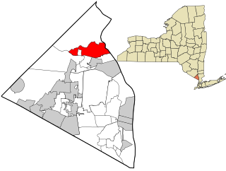
Stottville is a hamlet and census-designated place (CDP) in Columbia County, New York, United States. The population was 1,375 at the 2010 census.

Jefferson Heights is a hamlet and census-designated place (CDP) in Greene County, New York, United States. The population was 1,122 at the 2020 census.

<span class="mw-page-title-main">Fort Montgomery, New York</span> CDP in New York, United States

Fort Montgomery is a hamlet in Orange County, New York, United States. The population was 1,627 at the 2020 census. It is part of the Poughkeepsie–Newburgh–Middletown, NY Metropolitan Statistical Area as well as the larger New York–Newark–Bridgeport, NY-NJ-CT-PA Combined Statistical Area.

<span class="mw-page-title-main">East Kingston, New York</span> CDP in New York, United States

East Kingston is a hamlet in Ulster County, New York, United States. The population was 277 at the 2020 census.

<span class="mw-page-title-main">Malden, New York</span> CDP in New York, United States

Malden-on-Hudson (-), commonly known as Malden, is a hamlet in Ulster County, New York, United States. The population was 365 at the 2020 census.

<span class="mw-page-title-main">Saugerties South, New York</span> CDP in New York, United States

Saugerties South is a hamlet in Ulster County, New York, United States. The population was 2,442 at the 2020 census.

<span class="mw-page-title-main">Fairview, Westchester County, New York</span> CDP in New York, United States

Fairview is a hamlet and a census-designated place (CDP) located in the town of Greenburgh, Westchester County, New York, United States. The population was 3,099 at the 2010 census. As of 2000, Fairview had the fourth-highest percentage of African-Americans in New York.

<span class="mw-page-title-main">West Providence Township, Pennsylvania</span> Township in Pennsylvania, United States

West Providence Township is a township in Bedford County, Pennsylvania, United States. The population was 3,078 at the 2020 census.

<span class="mw-page-title-main">Valley View, York County, Pennsylvania</span> CDP in Pennsylvania, United States

Valley View is a census-designated place (CDP) in York County, Pennsylvania, United States. The population was 2,817 at the 2010 census.

<span class="mw-page-title-main">Williamstown (CDP), Massachusetts</span> Census-designated place in Massachusetts, United States

Williamstown is a census-designated place (CDP) in the town of Williamstown in Berkshire County, Massachusetts, United States. The population of the CDP was 4,325 at the 2010 census, out of 7,754 in the entire town.

Coeymans is a hamlet in Albany County, New York, United States. It is located on Route 144 in the southeastern part of the Town of Coeymans. The population was 835 at the 2000 census, which listed the community as a census-designated place (CDP), but it was not included as a CDP in the 2010 census.

Germantown is a census-designated place (CDP) in the town of Germantown in Columbia County, New York, United States, on the east side of the Hudson River. The population of the CDP was 845 at the 2010 census, out of a total town population of 1,954.

Ghent is a census-designated place (CDP) in the town of Ghent in Columbia County, New York, United States. The population of the CDP was 564 at the 2010 census, out of a total town population of 5,402.

<span class="mw-page-title-main">Pine Plains (CDP), New York</span> Census-designated place in New York, United States

Pine Plains is a hamlet and census-designated place (CDP) in Dutchess County, New York, United States. The population was 1,142 at the 2020 census. It is part of the Poughkeepsie–Newburgh–Middletown, NY Metropolitan Statistical Area as well as the larger New York–Newark–Bridgeport, NY-NJ-CT-PA Combined Statistical Area.

<span class="mw-page-title-main">Pleasant Valley (CDP), New York</span> Census-designated place in New York, United States

Pleasant Valley is a census-designated place (CDP) in the southwestern part of the town of Pleasant Valley in Dutchess County, New York, United States. The population was 1,145 at the 2010 census. It is part of the Poughkeepsie–Newburgh–Middletown, NY Metropolitan Statistical Area as well as the larger New York–Newark–Bridgeport, NY-NJ-CT-PA Combined Statistical Area.

Cairo is a hamlet and census-designated place (CDP) in the town of Cairo in Greene County, New York, United States. The population of the CDP was 1,368 at the 2020 census, out of 6,644 people in the entire town.

<span class="mw-page-title-main">Stony Point (CDP), New York</span> Census-designated place in New York, United States

Stony Point is a hamlet and census-designated place in the town of Stony Point, Rockland County, New York, United States. It is located north of West Haverstraw, east of Harriman State Park, south of Tomkins Cove, and west of the Hudson River. The population was 12,147 at the 2010 census.

<span class="mw-page-title-main">Hudson (CDP), Massachusetts</span> Census-designated place in Massachusetts, United States

Hudson is a census-designated place (CDP) comprising the densely developed central part of the town of Hudson in Middlesex County, Massachusetts, United States. The population of the CDP was 15,749 at the 2020 census, out of 20,092 in the entire town.

References

  1. "ArcGIS REST Services Directory". United States Census Bureau. Retrieved September 20, 2022.
  2. "US Gazetteer files: 2010, 2000, and 1990". United States Census Bureau. February 12, 2011. Retrieved April 23, 2011.
  3. 1 2 "Down the hill: An oral history of Glasco - Hudson Valley One". August 26, 2011. Retrieved February 18, 2024.
  4. "Glasco, NY". BestPlaces. Retrieved February 18, 2024.
  5. "Census of Population and Housing". Census.gov. Retrieved June 4, 2016.
  6. "U.S. Census website". United States Census Bureau . Retrieved January 31, 2008.