Saugerties South, New York

Last updated

Saugerties South, New York
CDP
Saugerties-south.gif
U.S. Census reference map
Ulster County New York incorporated and unincorporated areas Saugerties South highlighted.svg
Location in Ulster County and the state of New York.
Coordinates: 42°3′34″N73°57′22″W / 42.05944°N 73.95611°W / 42.05944; -73.95611
Country United States
State New York
County Ulster
Area
[1]
  Total1.29 sq mi (3.34 km2)
  Land1.07 sq mi (2.76 km2)
  Water0.22 sq mi (0.58 km2)
Population
 (2020)
  Total2,442
  Density2,290.81/sq mi (884.39/km2)
Time zone UTC-5 (EST)
  Summer (DST) UTC-4 (EDT)
FIPS code 36-65310

Saugerties South is a hamlet (and census-designated place) in Ulster County, New York, United States. The population was 2,442 at the 2020 census.

Contents

Saugerties South is a community south of the Village of Saugerties and Esopus Creek in the Town of Saugerties. U.S. Route 9W passes through the community.

Geography

Saugerties South, also known as Barclay Heights, is located at 42°3′34″N73°57′22″W / 42.05944°N 73.95611°W / 42.05944; -73.95611 (42.059450, -73.955975). [2]

According to the United States Census Bureau, the CDP has a total area of 1.2 square miles (3.1 km2), of which 1.0 square miles (2.5 km2) is land and 0.2 square mile (0.6 km2) (19.83%) is water.

The community lies on the west bank of the Hudson River.

Demographics

Historical population
CensusPop.Note
2000 2,285
2010 2,218−2.9%
2020 2,44210.1%
U.S. Decennial Census [3]

As of the census [4] of 2000, there were 2,285 people, 865 households, and 642 families residing in the CDP. The population density was 2,339.9 inhabitants per square mile (903.4/km2). There were 885 housing units at an average density of 906.3 per square mile (349.9/km2). The racial makeup of the CDP was 96.06% White, 1.44% African American, 0.09% Native American, 0.79% Asian, 0.35% from other races, and 1.27% from two or more races. Hispanic or Latino of any race were 2.76% of the population.

There were 865 households, out of which 35.5% had children under the age of 18 living with them, 60.5% were married couples living together, 10.1% had a female householder with no husband present, and 25.7% were non-families. 23.2% of all households were made up of individuals, and 12.5% had someone living alone who was 65 years of age or older. The average household size was 2.62 and the average family size was 3.07.

In the CDP, the population was spread out, with 25.8% under the age of 18, 5.4% from 18 to 24, 28.6% from 25 to 44, 24.2% from 45 to 64, and 16.1% who were 65 years of age or older. The median age was 39 years. For every 100 females, there were 90.4 males. For every 100 females age 18 and over, there were 85.2 males.

The median income for a household in the CDP was $52,468, and the median income for a family was $60,212. Males had a median income of $42,639 versus $27,155 for females. The per capita income for the CDP was $22,197. About 5.4% of families and 7.0% of the population were below the poverty line, including 11.9% of those under age 18 and 2.4% of those age 65 or over.

Related Research Articles

<span class="mw-page-title-main">Mineral, California</span> Census designated place in California, United States

Mineral is a boundaried but unincorporated forest village in Tehama County, California, United States. It has been part of a much larger census-designated place since 1980, for which the population was 123 at the 2010 census, down from 143 at the 2000 census.

<span class="mw-page-title-main">Strathmore, California</span> Census-designated place in California, United States

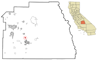
Strathmore is a census-designated place (CDP) in Tulare County, California, United States. The population was 2,819 at the 2010 census, up from 2,584 at the 2000 census.

<span class="mw-page-title-main">Girdletree, Maryland</span> CDP in Maryland, United States

Girdletree is a census-designated place in Worcester County, Maryland, United States. The population was 149 at the 2010 census. It is part of the Salisbury, Maryland-Delaware Metropolitan Statistical Area.

<span class="mw-page-title-main">Cedar Crest, New Mexico</span> Census-designated place in New Mexico, United States

Cedar Crest is a census-designated place (CDP) in Bernalillo County, New Mexico, United States. The population was 958 at the 2010 census. It is part of the Albuquerque Metropolitan Statistical Area.

Melrose Park is a suburban community and census-designated place (CDP) in Cayuga County, New York, United States. The population was 2,294 at the 2010 census. It is a suburb of Auburn, located south of the city in the town of Owasco.

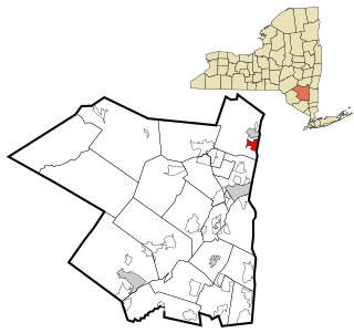
Claverack-Red Mills, commonly known as Claverack, is a census-designated place (CDP) in Columbia County, New York, United States. The population was 913 at the 2010 census.

<span class="mw-page-title-main">Glasco, New York</span> CDP in New York, United States

Glasco is a hamlet in Ulster County, New York, United States. The population was 2,013 at the 2020 census.

<span class="mw-page-title-main">Malden, New York</span> CDP in New York, United States

Malden-on-Hudson (-), commonly known as Malden, is a hamlet in Ulster County, New York, United States. The population was 365 at the 2020 census.

<span class="mw-page-title-main">Skyline View, Pennsylvania</span> Census-designated place in Pennsylvania, United States

Skyline View is an unincorporated community and census-designated place (CDP) in West Hanover Township, Dauphin County, Pennsylvania, United States. The population was 4,003 at the 2010 census, up from 2,307 at the 2000 census. It is part of the Harrisburg–Carlisle Metropolitan Statistical Area.

<span class="mw-page-title-main">Cecil-Bishop, Pennsylvania</span> CDP in Pennsylvania, United States

Cecil-Bishop is a census-designated place (CDP) in Washington County, Pennsylvania, United States. The population was 2,730 at the 2020 census. The census-designated place encompasses two unincorporated communities: larger Cecil in the west and smaller Bishop in the east.

<span class="mw-page-title-main">West Pike Run Township, Washington County, Pennsylvania</span> Township in Pennsylvania, United States

West Pike Run Township is a township in Washington County, Pennsylvania, United States. The population was 1,542 at the 2020 census.

Vista West is a census-designated place (CDP) in Natrona County, Wyoming, United States. It is part of the Casper, Wyoming Metropolitan Statistical Area. The population was 951 at the 2010 census.

<span class="mw-page-title-main">Lee (CDP), Massachusetts</span> Census-designated place in Massachusetts, United States

Lee is a census-designated place (CDP) located in the town of Lee in Berkshire County, Massachusetts, United States. The population was 2,051 at the 2010 census, out of 5,943 in the entire town of Lee.

Ghent is a census-designated place (CDP) in the town of Ghent in Columbia County, New York, United States. The population of the CDP was 564 at the 2010 census, out of a total town population of 5,402.

Cairo is a hamlet and census-designated place (CDP) in the town of Cairo in Greene County, New York, United States. The population of the CDP was 1,402 at the 2010 census, out of 6,610 people in the entire town.

<span class="mw-page-title-main">East Greenbush (CDP), New York</span> CDP in New York, United States

East Greenbush is a census-designated place (CDP) in Rensselaer County, New York, United States. The population was 4,487 at the 2010 census.

<span class="mw-page-title-main">Poestenkill (CDP), New York</span> CDP in New York, United States

Poestenkill is a hamlet in Rensselaer County, New York, United States. The population was 1,061 at the 2010 census. The name is taken from Poesten Kill, a stream in the area.

<span class="mw-page-title-main">Townsend (CDP), Massachusetts</span> Census-designated place in Massachusetts, United States

Townsend is a census-designated place (CDP) comprising the main village in the town of Townsend in Middlesex County, Massachusetts, United States. The population was 1,213 at the 2020 census, out of 9,127 in the entire town.

<span class="mw-page-title-main">Saugerties (village), New York</span> Village in Ulster County, New York, United States

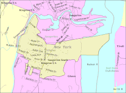
Saugerties is a village in Ulster County, New York, United States. The population was 3,899 at the 2020 census, showing a slight decline from the 3,971 counted at the 2010 census.

Warrensburg is a census-designated place (CDP) in Warren County, New York, United States. The population was 3,208 at the 2000 census. It is part of the Glens Falls Metropolitan Statistical Area.

References

  1. "ArcGIS REST Services Directory". United States Census Bureau. Retrieved September 20, 2022.
  2. "US Gazetteer files: 2010, 2000, and 1990". United States Census Bureau. February 12, 2011. Retrieved April 23, 2011.
  3. "Census of Population and Housing". Census.gov. Retrieved June 4, 2016.
  4. "U.S. Census website". United States Census Bureau . Retrieved January 31, 2008.