Lincoln Park, New York

Last updated
Lincoln Park, New York
CDP
Ulster County New York incorporated and unincorporated areas Lincoln Park highlighted.svg
Location in Ulster County and the state of New York.
Coordinates: 41°57′5″N73°59′40″W / 41.95139°N 73.99444°W / 41.95139; -73.99444 Coordinates: 41°57′5″N73°59′40″W / 41.95139°N 73.99444°W / 41.95139; -73.99444
Country United States
State New York
County Ulster
Area
[1]
  Total1.56 sq mi (4.04 km2)
  Land1.53 sq mi (3.96 km2)
  Water0.03 sq mi (0.08 km2)
Elevation
187 ft (57 m)
Population
 (2020)
  Total2,545
  Density1,663.40/sq mi (642.08/km2)
Time zone UTC-5 (Eastern (EST))
  Summer (DST) UTC-4 (EDT)
FIPS code 36-42488
GNIS feature ID0955377 [2]

Lincoln Park is a hamlet (and census-designated place) in Ulster County, New York, United States. The population was 2,366 at the 2010 census.

Lincoln Park is in the southern part of the Town of Ulster, adjacent to the northern city boundary of the City of Kingston.

Lincoln Park is at coordinates 41°57′5″N73°59′40″W / 41.95139°N 73.99444°W / 41.95139; -73.99444 .

Demographics

Historical population
CensusPop.
2020 2,545
U.S. Decennial Census [3]

At the 2000 census, [4] there were 2,337 people, 1,064 households and 619 families residing in the CDP. The population density was 1,716.7 per square mile (663.5/km2). There were 1,114 housing units at an average density of 818.3/sq mi (316.3/km2). The racial makeup of the CDP was 93.37% White, 3.34% African American, 0.30% Native American, 1.50% Asian, 0.04% Pacific Islander, 0.30% from other races, and 1.16% from two or more races. Hispanic or Latino of any race were 2.57% of the population.

There were 1,064 households, of which 24.2% had children under the age of 18 living with them, 43.7% were married couples living together, 10.2% had a female householder with no husband present, and 41.8% were non-families. 36.7% of all households were made up of individuals, and 21.3% had someone living alone who was 65 years of age or older. The average household size was 2.18 and the average family size was 2.86.

20.6% of the population were under the age of 18, 6.7% from 18 to 24, 28.2% from 25 to 44, 21.4% from 45 to 64, and 23.2% who were 65 years of age or older. The median age was 42 years. For every 100 females there were 84.5 males. For every 100 females age 18 and over, there were 80.0 males.

The median household income was $34,583 and the median family income was $44,279. Males had a median income of $35,000 compared with $24,769 for females. The per capita income for the CDP was $19,863. About 10.2% of families and 12.9% of the population were below the poverty line, including 26.6% of those under age 18 and 13.4% of those age 65 or over.

Related Research Articles

<span class="mw-page-title-main">Paulden, Arizona</span> CDP in Yavapai County, Arizona

Paulden is a census designated place (CDP) in Yavapai County, Arizona, United States. The population was 5,231 at the 2010 census.

<span class="mw-page-title-main">Harlem, Florida</span> Census-designated place in Florida, United States

Harlem is a census-designated place (CDP) in Hendry County, Florida, United States. The population is 2,397 as of 2022.

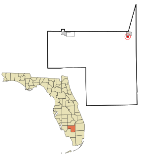
Plantation Mobile Home Park is a census-designated place (CDP) in Palm Beach County, Florida, United States. The population was 1,218 at the 2000 census.

<span class="mw-page-title-main">Frankfort Square, Illinois</span> Census-designated place in Illinois, United States

Frankfort Square is a census-designated place (CDP) in Will County, Illinois, United States. Per the 2020 census, the population was 8,968. Frankfort Square has a fountain lake near Frankfort Square Road and Saint Francis Road and schools like Lincoln-Way North High School and Summit Hill Junior High.

<span class="mw-page-title-main">West Wareham, Massachusetts</span> Census-designated place in Massachusetts, United States

West Wareham is a census-designated place (CDP) in the town of Wareham in Plymouth County, Massachusetts, United States. The population was 2,064 at the 2010 census.

<span class="mw-page-title-main">Accord, New York</span> Hamlet in the state of New York, United States

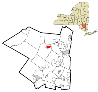
Accord is a hamlet and census-designated place (CDP) in Ulster County, New York, United States. Accord is located in the eastern part of the Town of Rochester along US 209. Accord is the seat of town government.

<span class="mw-page-title-main">East Kingston, New York</span> CDP in New York, United States

East Kingston is a hamlet in Ulster County, New York, United States. The population was 276 at the 2010 census.

<span class="mw-page-title-main">Highland, Ulster County, New York</span> Census-designated place in New York, United States

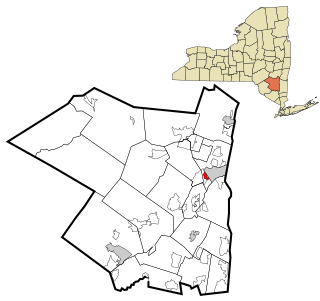
Highland is a hamlet in Ulster County, New York, United States. The population was 5,647 at the 2010 census. It is part of the New York City Combined Statistical area.

<span class="mw-page-title-main">Hillside, New York</span> CDP in New York, United States

Hillside is a census-designated place (CDP) in Ulster County, New York, United States. The population was 877 at the 2010 census.

<span class="mw-page-title-main">Lake Katrine, New York</span> CDP in New York, United States

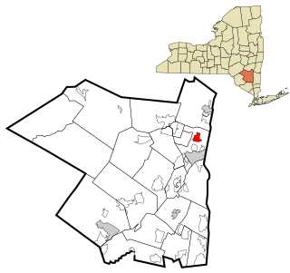
Lake Katrine is a hamlet in Ulster County, New York, United States. The population was 2,397 at the 2010 census.

<span class="mw-page-title-main">Malden, New York</span> CDP in New York, United States

Malden-on-Hudson (-), commonly known as Malden, is a hamlet in Ulster County, New York, United States. The population was 405 at the 2010 census.

<span class="mw-page-title-main">Marlboro, New York</span> CDP in New York, United States

Marlboro is a hamlet in Ulster County, New York, United States. The population was 3,669 at the 2010 census. Marlboro is in the southeastern part of the town of Marlborough, located in the southeastern corner of the county.

<span class="mw-page-title-main">Port Ewen, New York</span> CDP in New York, United States

Port Ewen is a hamlet in Ulster County, New York, United States. The population was 3,546 at the 2010 census.

<span class="mw-page-title-main">Shokan, New York</span> CDP in New York, United States

Shokan is a hamlet located in the town of Olive in Ulster County, New York, United States, within the Catskill Park. The population was 1,183 at the 2010 census.

<span class="mw-page-title-main">Stone Ridge, New York</span> CDP in New York, United States

Stone Ridge is a hamlet in Ulster County, New York, United States. The population was 1,173 at the 2010 census.

West Wyomissing is a census-designated place (CDP) in Spring Township, Berks County, Pennsylvania, United States. The population was 3,407 at the 2010 census.

Lawson Heights is a census-designated place (CDP) in Unity Township, Westmoreland County, Pennsylvania, United States. The population was 2,339 at the 2000 census.

Fairfield Glade is a resort, retirement community and census-designated place (CDP) in Cumberland County, Tennessee, United States. The population was 9,152 at the 2020 census, up over 3,000 from the 2010 census.

<span class="mw-page-title-main">Lyndhurst, Virginia</span> CDP in Virginia, United States

Lyndhurst is a census-designated place (CDP) in Augusta County, Virginia, United States. The population was 1,490 at the 2010 census. It is part of the Staunton–Waynesboro Micropolitan Statistical Area.

<span class="mw-page-title-main">Rutland (CDP), Massachusetts</span> CDP in Massachusetts, United States

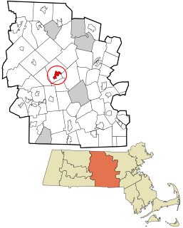
Rutland is a census-designated place (CDP) in the town of Rutland in Worcester County, Massachusetts, United States. The population was 2,111 at the 2010 census.

References

  1. "ArcGIS REST Services Directory". United States Census Bureau. Retrieved September 20, 2022.
  2. "Lincoln Park". Geographic Names Information System . United States Geological Survey, United States Department of the Interior . Retrieved 2009-02-24.
  3. "Census of Population and Housing". Census.gov. Retrieved June 4, 2016.
  4. "U.S. Census website". United States Census Bureau . Retrieved 2008-01-31.