West Hurley, New York

Last updated

West Hurley, New York
CDP
Ulster County New York incorporated and unincorporated areas West Hurley highlighted.svg
Location in Ulster County and the state of New York.
Coordinates: 42°0′16″N74°6′34″W / 42.00444°N 74.10944°W / 42.00444; -74.10944
Country United States
State New York
County Ulster
Area
[1]
  Total3.79 sq mi (9.81 km2)
  Land3.79 sq mi (9.81 km2)
  Water0.00 sq mi (0.00 km2)
Elevation
597 ft (182 m)
Population
 (2020)
  Total1,917
  Density506.21/sq mi (195.43/km2)
Time zone UTC-5 (Eastern (EST))
  Summer (DST) UTC-4 (EDT)
ZIP code
12491
Area code 845
FIPS code 36-80291 [2]
GNIS feature ID0969272 [3]

West Hurley is a hamlet (and census-designated place) in Ulster County, New York, United States. The population was 1,917 at the 2020 census.

Contents

West Hurley is located in the Town of Hurley and is inside the Catskill Park. The community is northwest of Kingston on Route 28.

It was one of many villages that were flooded during the creation of the Ashokan Reservoir. The village was moved, and currently resides on the northern bank of the reservoir.

Geography

West Hurley is located at 42°0′16″N74°6′34″W / 42.00444°N 74.10944°W / 42.00444; -74.10944 (42.004442, -74.109312). [4]

According to the United States Census Bureau, the CDP has a total area of 3.8 square miles (9.8 km2), all land.

Demographics

Historical population
CensusPop.Note
2000 2,105
2010 1,939−7.9%
2020 1,917−1.1%
U.S. Decennial Census [5]

As of the census [2] of 2000, there were 2,105 people, 866 households, and 600 families residing in the CDP. The population density was 557.2 inhabitants per square mile (215.1/km2). There were 954 housing units at an average density of 252.5 per square mile (97.5/km2). The racial makeup of the CDP was 94.54% White, 1.47% African American, 1.76% Asian, 0.10% Pacific Islander, 0.76% from other races, and 1.38% from two or more races. Hispanic or Latino of any race were 2.09% of the population.

There were 866 households, out of which 29.0% had children under the age of 18 living with them, 56.7% were married couples living together, 9.1% had a female householder with no husband present, and 30.7% were non-families. 25.3% of all households were made up of individuals, and 11.0% had someone living alone who was 65 years of age or older. The average household size was 2.40 and the average family size was 2.89.

In the CDP, the population was spread out, with 22.4% under the age of 18, 4.1% from 18 to 24, 21.0% from 25 to 44, 34.5% from 45 to 64, and 17.9% who were 65 years of age or older. The median age was 46 years. For every 100 females, there were 88.5 males. For every 100 females age 18 and over, there were 84.9 males.

The median income for a household in the CDP was $54,615, and the median income for a family was $66,250. Males had a median income of $50,114 versus $30,000 for females. The per capita income for the CDP was $27,992. About 4.7% of families and 6.5% of the population were below the poverty line, including 10.6% of those under age 18 and 5.6% of those age 65 or over.

Related Research Articles

<span class="mw-page-title-main">Avocado Heights, California</span> Census-designated place in California, United States

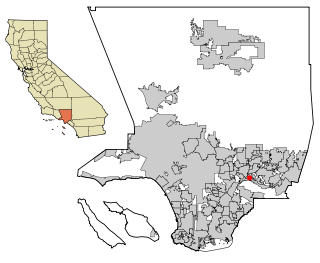
Avocado Heights is an unincorporated census-designated place (CDP) in the San Gabriel Valley of Los Angeles County, California, United States. It is almost entirely surrounded by the City of Industry with only a small strip of unincorporated Los Angeles County separating it from South El Monte. It is in close proximity to both the Pomona (SR-60) and San Gabriel (I-605) freeways. To the west is the San Gabriel River and the California Country Club. Avocado Heights is approximately 15 miles (24 km) from the downtown Los Angeles Civic Center. The population was 15,411 at the 2010 census, up from 15,148 at the 2000 census.

<span class="mw-page-title-main">North Tustin, California</span> Place in California, United States

North Tustin is an unincorporated community in Orange County, California. The population was 24,917 at the 2010 Census, up from 24,044 in 2000. For statistical purposes, the United States Census Bureau has defined North Tustin as a census-designated place (CDP). It is both the largest CDP and largest unincorporated community in Orange County. The CDP's name was changed from Tustin Foothills in 2005. Located outside the city limits of Tustin, North Tustin has 92705 and 92780 ZIP Codes.

<span class="mw-page-title-main">Cypress Lakes, Florida</span> Unincorporated place in Florida, United States

Cypress Lakes was a census-designated place (CDP) in Palm Beach County, Florida, United States. The population was 1,468 at the 2000 census.

<span class="mw-page-title-main">Shokan, New York</span> CDP in New York, United States

Shokan is a hamlet located in the town of Olive in Ulster County, New York, United States, within the Catskill Park. The population was 1,075 at the 2020 census.

<span class="mw-page-title-main">Northridge, Clark County, Ohio</span> Census-designated place in Ohio, United States

Northridge is a census-designated place (CDP) in Clark County, Ohio, United States. The population was 7,518 at the 2020 census. It is part of the Springfield, Ohio Metropolitan Statistical Area.

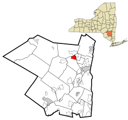
Reiffton is a census-designated place (CDP) in Exeter Township, Berks County, Pennsylvania, United States. The population was 4,178 at the 2010 census.

<span class="mw-page-title-main">Woodside, Pennsylvania</span> Census-designated place in Pennsylvania, United States

Woodside is a census-designated place (CDP) in Bucks County, Pennsylvania, United States. The population was 2,425 at the 2010 census.

<span class="mw-page-title-main">Pymatuning Central, Pennsylvania</span> Census-designated place in Pennsylvania, United States

Pymatuning Central is a census-designated place (CDP) in Crawford County, Pennsylvania, United States. The population was 2,269 at the 2010 census.

<span class="mw-page-title-main">Trevorton, Pennsylvania</span> CDP in Pennsylvania, United States

Trevorton is a census-designated place (CDP) in Zerbe Township, Northumberland County, Pennsylvania, United States. The population was 1,834 at the 2010 census.

<span class="mw-page-title-main">York Haven, Pennsylvania</span> Borough in Pennsylvania, United States

York Haven is a borough in York County, Pennsylvania, United States. The population was 691 at the 2020 census. The borough is the home of the Brunner Island coal-fired electrical generation plant, located on the Susquehanna River on Wago Road and operated by PPL Corporation.

<span class="mw-page-title-main">Lopeño, Texas</span> CDP in Texas, United States

Lopeño is a census-designated place (CDP) in Zapata County, Texas, United States. The population was 174 at the 2010 census.

<span class="mw-page-title-main">Greenville, Virginia</span> CDP in Virginia, United States

Greenville is a census-designated place (CDP) in Augusta County, Virginia, United States. The population was 832 at the 2010 census. It is part of the Staunton–Waynesboro Micropolitan Statistical Area.

<span class="mw-page-title-main">John Sam Lake, Washington</span> Former CDP in Washington, United States

John Sam Lake is a former census-designated place (CDP) in Snohomish County, Washington, United States. The population was 753 at the 2000 census. The CDP was discontinued at the 2010 census.

<span class="mw-page-title-main">Warm Beach, Washington</span> CDP in Washington, United States

Warm Beach is a census-designated place (CDP) in Snohomish County, Washington, United States. The population was 2,437 at the 2010 census.

<span class="mw-page-title-main">Casper Mountain, Wyoming</span> CDP in Wyoming, United States

Casper Mountain is a census-designated place (CDP) on Casper Mountain in Natrona County, Wyoming, United States. It is part of the Casper, Wyoming Metropolitan Statistical Area. The population was 401 at the 2010 census.

<span class="mw-page-title-main">Oxford (CDP), Massachusetts</span> CDP in Massachusetts, United States

Oxford is a census-designated place (CDP) in the town of Oxford in Worcester County, Massachusetts, United States. The population was 6,103 at the 2010 census.

<span class="mw-page-title-main">Sturbridge (CDP), Massachusetts</span> CDP in Massachusetts, United States

Sturbridge is a census-designated place (CDP) in the town of Sturbridge in Worcester County, Massachusetts, United States. The population was 2,253 at the 2010 census.

<span class="mw-page-title-main">Rib Mountain (CDP), Wisconsin</span> CDP in Wisconsin, United States

Rib Mountain is a census-designated place (CDP) in the town of Rib Mountain in Marathon County, Wisconsin, United States. The population was 6,061 at the 2020 census.

<span class="mw-page-title-main">Woodstock (CDP), New York</span> CDP in New York, United States

Woodstock is a hamlet in Ulster County, New York, United States. The population was 2,088 according to the 2010 census. The community of Woodstock is in the eastern part of the Town of Woodstock and is northwest of Kingston. It is located along NY 212 near its junction with NY 375. Although the name of the community and the town lent its name to the Woodstock Festival, that event did not take place in Woodstock.

Andrews Air Force Base is a census-designated place (CDP) covering the residential population of Andrews Air Force Base/Joint Base Andrews, in Prince George's County, Maryland, Maryland, United States. The population at the 2020 Census was 3,025.

References

  1. "ArcGIS REST Services Directory". United States Census Bureau. Retrieved September 20, 2022.
  2. 1 2 "U.S. Census website". United States Census Bureau . Retrieved January 31, 2008.
  3. "US Board on Geographic Names". United States Geological Survey. October 25, 2007. Retrieved January 31, 2008.
  4. "US Gazetteer files: 2010, 2000, and 1990". United States Census Bureau. February 12, 2011. Retrieved April 23, 2011.
  5. "Census of Population and Housing". Census.gov. Retrieved June 4, 2016.