Stonehenge is a prehistoric monument on Salisbury Plain in Wiltshire, England, two miles (3 km) west of Amesbury. It consists of an outer ring of vertical sarsen standing stones, each around 13 feet (4.0 m) high, seven feet (2.1 m) wide, and weighing around 25 tons, topped by connecting horizontal lintel stones. Inside is a ring of smaller bluestones. Inside these are free-standing trilithons, two bulkier vertical sarsens joined by one lintel. The whole monument, now ruinous, is aligned towards the sunrise on the summer solstice. The stones are set within earthworks in the middle of the densest complex of Neolithic and Bronze Age monuments in England, including several hundred tumuli.

The Preseli Hills or, as they are known locally and historically, Preseli Mountains is a range of hills in north Pembrokeshire, west Wales, mostly within the Pembrokeshire Coast National Park.

Bluestone is a cultural or commercial name for a number of dimension or building stone varieties, including:

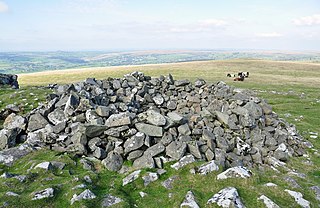
Bedd Arthur is a possibly Neolithic hengiform monument megalithic site in the Preseli Hills in the Welsh county of Pembrokeshire. Thirteen upright stones and at least 2 fallen ones, each around 0.6 metres (2.0 ft) high form an oval horseshoe with similarities to the earliest form of Stonehenge.

Mynachlog-ddu is a village, parish and community in the Preseli Hills, Pembrokeshire, Wales. The community includes the parish of Llangolman.
Michael Parker Pearson, is an English archaeologist specialising in the study of the Neolithic British Isles, Madagascar and the archaeology of death and burial. A professor at the UCL Institute of Archaeology, he previously worked for 25 years as a professor at the University of Sheffield in England, and was the director of the Stonehenge Riverside Project. A prolific author, he has also written a variety of books on the subject.

The Altar Stone is a recumbent central megalith at Stonehenge in England, dating to Stonehenge phase 3i, around 2600 BCE. It is identified as Stone 80 in scholarly articles.

Mynydd Carningli is a mountain in the Preseli Hills near the town of Newport, Pembrokeshire, Wales. It has both prehistoric and historic remains.

Banc Du is a prominent, fairly flat-topped southwards-projecting promontory of Foel Eryr, at about 334m OD at the west end of the Preseli Hills in north Pembrokeshire, Wales. First spotted during an aerial photographic survey of the region in 1990, this hilltop enclosure consists of two non-concentric and incomplete earthworks that define a roughly oval area around the hilltop, amidst a series of cultivation features and abandoned trackways.
Stonehenge has been the subject of many theories about its origin, ranging from the academic worlds of archaeology to explanations from mythology and the paranormal.

Whitesands Bay is a Blue Flag beach situated on the St David's peninsula in the Pembrokeshire Coast National Park, Wales. Whitesand Bay, on some maps, located 2 miles (3.2 km) west of St. Davids and 1 mile (1.6 km) south of St Davids Head, has been described as the best surfing beach in Pembrokeshire.

The Q and R Holes are a series of concentric sockets which currently represent the earliest known evidence for a stone structure on the site of Stonehenge.

Bluestonehenge or Bluehenge is a prehistoric henge and stone circle monument that was discovered by the Stonehenge Riverside Project about 1 mile (1.6 km) south-east of Stonehenge in Wiltshire, England. All that remains of the site is the ditch of the henge and a series of stone settings, none of which is visible above ground.
Bringing Back the Bluestones is a stage play by Derek Webb about a pressure group from Pembrokeshire campaigning to have the Stonehenge bluestones returned to Wales. It followed the fortunes of Roy Brown as he sets up the group, Carreg Las, and campaigns for the return of the stones to the Preseli Hills.
Timothy Darvill OBE is an English archaeologist and author, best known for his publications on prehistoric Britain and his excavations in England, Wales, and the Isle of Man. He is Professor of Archaeology in the Faculty of Science and Technology Bournemouth University in England. In April 2008 he co-directed excavations within Stonehenge, together with Professor Geoffrey Wainwright and Dr Miles Russell, to examine the early stone structures on the site. The work featured heavily in a BBC Timewatch programme which examined the theory that Stonehenge was a prehistoric centre of healing. He was appointed OBE in the 2010 Queen's Birthday Honours.

The Fishguard Volcanic Group is an Ordovician lithostratigraphic group in west Wales. The name is derived from the town of Fishguard in Pembrokeshire. This assemblage of rocks has also been referred to as the Fishguard Volcanic Series or Fishguard Volcanic Complex. These rocks are believed to be the source of the 'bluestones' which form a part of the well-known prehistoric monument of Stonehenge in southern England.
A tor cairn is a prehistoric cult site occurring in the British Isles, especially in Cornwall and Devon but also in Wales. It consists of a circular enclosure of stones or a platform of loose rocks surrounding a natural tor, sometimes encircled by a ditch. The diameter of the roughly 35 tor cairns ranges from 12 to over 30 metres and their height varies from 0.5 to 4.0 metres. There is usually an entrance to the enclosed area and pits in the ground between the rock outcrop (tor) itself and the enclosure.
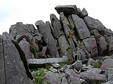
Craig Rhos-y-felin is a rocky outcrop on the north side of the Preseli Mountains in Wales, which is designated as a RIGS site on the basis of its geological and geomorphological interest. It is accepted by some in the archaeological community that it is the site of a quarry, used together with one at Carn Goedog, for gathering stones used at Stonehenge, most notably as the source of some of the foliated rhyolite found in the Stonehenge "debitage". This is disputed by others, who believe that all of the features at the site, apart from evidence of intermittent occupation over a long period, are of natural origin. Some believe that the site was used as a quarry in both the Neolithic and Bronze Ages, around 4000 to 5000 years ago, and the rock's shape, like a pillar, allowed the stones to be quarried with relative ease compared to stones taken from other places. Others argue that if prehistoric men had wanted to obtain monoliths for use as standing stones, all they had to do was collect them from the abundant glacial erratics littering the landscape.

Waun Mawn is the site of a possible dismantled Neolithic stone circle in the Preseli Hills of Pembrokeshire, Wales. The diameter of the postulated circle is estimated to be 110 m (360 ft), the third largest diameter for a British stone circle.
The geology of Pembrokeshire in Wales inevitably includes the geology of the Pembrokeshire Coast National Park which extends around the larger part of the county’s coastline and where the majority of rock outcrops are to be seen. Pembrokeshire’s bedrock geology is largely formed from a sequence of sedimentary and igneous rocks originating during the late Precambrian and the Palaeozoic era, namely the Ediacaran, Cambrian, Ordovician, Silurian, Devonian and Carboniferous periods, i.e. between 635 and 299 Ma. The older rocks in the north of the county display patterns of faulting and folding associated with the Caledonian Orogeny. On the other hand, the late Palaeozoic rocks to the south owe their fold patterns and deformation to the later Variscan Orogeny.