Kinnear is an unincorporated community in central Fremont County, Wyoming, United States. It lies along U.S. Route 26 near its intersection with Wyoming Highway 133, northwest of the city of Riverton and north of the city of Lander, the county seat of Fremont County. Its elevation is 5,400 feet (1,646 m). Kinnear has a post office, with the ZIP code of 82516.
Emblem is an unincorporated community in western Big Horn County, Wyoming, United States. The community has an official population of 10, although the surrounding rural area increases the number to over 100. It lies along the concurrent U.S. Routes 14, 16 and 20, west-northwest of the town of Basin, the county seat of Big Horn County. Its elevation is 4,449 ft (1,356 m). Although Emblem is unincorporated, it has a post office, with the ZIP code of 82422.
Freedom is an unincorporated community in both northeastern Caribou County, Idaho, and northwestern Lincoln County, Wyoming, in the United States; the Wyoming portion of the community is also a census-designated place (CDP). The population was 214 at the 2010 census.
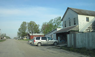
Watkins is an unincorporated community and census-designated place in southeastern Benton County, Iowa, United States. As of the 2010 census, it had a population of 118. Watkins lies along local roads south of the city of Vinton, the county seat of Benton County. Its elevation is 830 feet (250 m) above sea level. Although Watkins is unincorporated, it has a post office, with the ZIP code of 52354, which opened on 15 December 1873.
Oran is an unincorporated community in southwestern Fayette County, Iowa, United States. It lies along local roads southwest of the city of West Union, the county seat of Fayette County, and west of the city of Oelwein, the largest city in Fayette County. Its elevation is 1,043 feet (318 m). Although Oran is unincorporated, it has a post office with the ZIP code of 50664.
Argyle is an unincorporated community in southwestern Lee County, Iowa, United States. As of the 2020 census, its population was 91.

Arminto is an unincorporated community in northwestern Natrona County, Wyoming, United States. It lies along local roads west of the city of Casper, the county seat of Natrona County. Its elevation is 6,053 feet (1,845 m).
Banner is an unincorporated community in southern Sheridan County, Wyoming, United States. It lies near Interstate 90, south of the city of Sheridan, the county seat of Sheridan County. Its elevation is 4,580 feet (1,400 m). Although Banner is unincorporated, it had a post office, with the ZIP code of 82832, which closed in 2004. Public education in the community of Banner is provided by Sheridan County School District #2.

Beulah is a census-designated place (CDP) in eastern Crook County, Wyoming, United States, along Sand Creek, a tributary of the Belle Fourche River. According to local residents, the population is 33. When the 2010 census reported the population as 73, the highway sign at the town entrance was changed. In 2012, Beulah residents succeeded in appealing to the Wyoming Governor to remove the new sign and replace it with one that proclaimed the population to be 33.
Garrett is an unincorporated community in northern Albany County, Wyoming, United States, along the North Laramie River. It lies along local roads north of the city of Laramie, the county seat of Albany County. Its elevation is 6,785 ft (2,068 m), and it is located at 42°6′48″N105°36′36″W. Although Garrett is unincorporated, it once had a post office, with the ZIP code of 82058. The building remains, though is no longer in use. Garrett is also home to River Bridge School, a one-room schoolhouse that is part of Albany County School District #1. Aside from the schoolhouse, the land is privately owned.
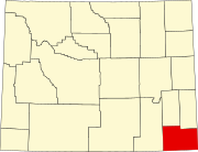
Hillsdale is an unincorporated community and census-designated place in southeastern Laramie County, Wyoming, United States. As of the 2010 census, it had a population of 47. It lies along local roads east of the city of Cheyenne, the county seat of Laramie County. Its elevation is 5,640 feet (1,720 m) above sea level. Although Hillsdale is unincorporated, it has a post office, with the ZIP code of 82060. Public education in the community of Hillsdale is provided by Laramie County School District #2.
Horse Creek is an unincorporated community in western Laramie County, Wyoming, United States. It lies between Horse Creek to the north, and the South Fork of Horse Creek to the south, along WYO 211 northwest of the city of Cheyenne, the county seat of Laramie County. Its elevation is 6,506 feet (1,983 m). Although Horse Creek is unincorporated, it does not have a post office, but it does have a ZIP code of 82061. As of the 2010 census, Horse Creek had an estimated population of 39.
Jay Em is an unincorporated community in northern Goshen County, Wyoming, United States, just below the headwaters of the Rawhide Creek, on the old Texas Trail. It lies along U.S. Route 85, 35 miles north of the city of Torrington, the county seat of Goshen County. Its elevation is 4,590 feet (1,399 m). Although unincorporated, Jay Em has a post office, with ZIP code 82219.

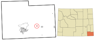
Savery is an unincorporated community in southeastern Carbon County, Wyoming, United States, on the upper Little Snake River. It lies along WYO 70 south of the city of Rawlins, the county seat of Carbon County. Its elevation is 6,473 feet (1,973 m). Although Savery is unincorporated, it has a post office with ZIP code 82332, and is home to the Little Snake River Museum.
Maryneal is an unincorporated community in southern Nolan County, Texas, United States. It lies along FM 608 south of the city of Sweetwater, the county seat of Nolan County. Its elevation is 2,566 feet (782 m). Although Maryneal is unincorporated, it has a post office, with the ZIP code of 79535; the ZCTA for ZIP Code 79535 had a population of 181 at the 2000 census.
Dawn is an unincorporated community in eastern Deaf Smith County, Texas, United States. It lies along FM 809 northeast of the city of Hereford, the county seat of Deaf Smith County. Its elevation is 3,802 feet (1,159 m). Although Dawn is unincorporated, it has a post office, with the ZIP code of 79025; the ZCTA for ZIP Code 79025 had a population of 138 at the 2000 census.
Carlsbad is a census-designated place and unincorporated community in northwest Tom Green County, Texas, United States. It lies along U.S. Route 87 northwest of the city of San Angelo, the county seat of Tom Green County. Its elevation is 2,024 feet (617 m). Although Carlsbad is unincorporated, it has a post office, with the ZIP code of 76934; the ZCTA for ZIP Code 76934 had a population of 1,332 at the 2000 census.
Mereta is an unincorporated community in eastern Tom Green County, Texas, United States. It lies along local roads east of the city of San Angelo, the county seat of Tom Green County. Its elevation is 1,755 feet (535 m). Although Mereta is unincorporated, it has a post office, with the ZIP code of 76940; the ZCTA for ZIP Code 76940 had a population of 138 at the 2000 census.

Waring is an unincorporated community in northwestern Kendall County, Texas, United States. It lies along local roads and the Guadalupe River, northwest of the city of Boerne, the county seat of Kendall County. Its elevation is 1,345 feet (410 m). Although Waring is unincorporated, it has a post office, with the ZIP code of 78074; the ZCTA for ZIP Code 78074 had a population of 59 at the 2000 census. The community is part of the San Antonio Metropolitan Statistical Area.
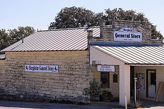
Bergheim is an unincorporated community in eastern Kendall County, Texas, United States known for its German-Texan culture and heritage. It lies along State Highway 46 east of the city of Boerne, the county seat of Kendall County. Its elevation is 1,437 feet (438 m). Although Bergheim is unincorporated, it has a post office, with the ZIP code of 78004; the ZCTA for ZIP Code 78004, consisting mostly of rural land, had a population of 1,183 at the 2010 census. The community is part of the San Antonio metropolitan statistical area. Bergheim is still a predominantly a ranching and agricultural community.