Related Research Articles
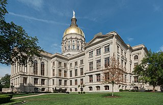
The Georgia State Capitol is an architecturally and historically significant building in Atlanta, Georgia, United States. The building has been named a National Historic Landmark which is listed on the National Register of Historic Places. As the primary office building of Georgia's government, the capitol houses the offices of the governor, lieutenant governor, and secretary of state on the second floor, chambers in which the General Assembly, consisting of the Georgia State Senate and Georgia House of Representatives, meets annually from January to April. The fourth floor houses visitors' galleries overlooking the legislative chambers and a museum located near the rotunda in which a statue of Miss Freedom caps the dome.

Alfred Holt Colquitt was an American lawyer, preacher, soldier, and politician. Elected as the 49th Governor of Georgia (1877–1882), he was one of numerous Democrats elected to office as white conservatives took back power in the state at the end of the Reconstruction era. He was elected by the Georgia state legislature to two terms as U.S. Senator, serving from 1883 to 1894 and dying in office. He had served as a United States officer in the Mexican-American War and in the Confederate States Army during the American Civil War, reaching the rank of major general.
The Georgia Railroad and Banking Company also seen as "GARR", was a historic railroad and banking company that operated in the U.S. state of Georgia. In 1967 it reported 833 million revenue-ton-miles of freight and 3 million passenger-miles; at the end of the year it operated 331 miles (533 km) of road and 510 miles (820 km) of track.

The Central of Georgia Railway started as the Central Rail Road and Canal Company in 1833. As a way to better attract investment capital, the railroad changed its name to Central Rail Road and Banking Company of Georgia. This railroad was constructed to join the Macon and Western Railroad at Macon, Georgia, in the United States, and run to Savannah. This created a rail link from Chattanooga, on the Tennessee River, to seaports on the Atlantic Ocean. It took from 1837 to 1843 to build the railroad from Savannah to the eastern bank of the Ocmulgee River at Macon; a bridge into the city was not built until 1851.
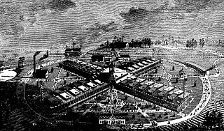
International Cotton Exposition (I.C.E.) was a world's fair held in Atlanta, Georgia, from October 4 to December 31 of 1881. The location was along the Western & Atlantic Railroad tracks near the present-day King Plow Arts Center development in the West Midtown area. It planned to show the progress made since the city's destruction during the Battle of Atlanta and new developments in cotton production. It demonstrated the rebirth of Atlanta and the South by announcing an end to the Reconstruction Era and the sectional hostilities that had plagued the nation for several decades.
The Kimball House was the name of two historical hotels in Atlanta, Georgia. United States. Both were constructed on an entire city block at the south-southeast corner of Five Points, bounded by Whitehall Street, Decatur Street, Pryor Street, and Wall Street, a block now occupied by a multi-story parking garage.

The Telegraph, frequently called The Macon Telegraph, is the primary print news organ in Middle Georgia. It is the third-largest newspaper in the State of Georgia. Founded in 1826, The Telegraph has undergone several name changes, mergers, and publishers. As of June 2006, the paper is owned by The McClatchy Company, a publicly traded American publishing company.

The Georgia Trust for Historic Preservation is the United States' largest statewide, nonprofit preservation organization with more than 8,000 members. Founded in 1973 by Mary Gregory Jewett and others, the Trust is committed to preserving and enhancing Georgia's communities and their diverse historic resources for the education and enjoyment of all.

Interstate 75 (I-75) in the US state of Georgia travels north–south along the U.S. Route 41 (US 41) corridor in the central part of the state, traveling through the cities of Valdosta, Macon, and Atlanta. It is also designated—but not signed—as State Route 401 (SR 401).

Rufus Brown Bullock was an American politician and businessman from Georgia. A Republican, he served as the state's governor during the Reconstruction Era. He called for equal economic opportunity and political rights for blacks and whites in Georgia. He also promoted public education for both, and encouraged railroads, banks, and industrial development. During his governorship, he requested federal military help to ensure the rights of freedmen; this made him "the most hated man in the state", and he had to flee the state without completing his term. After returning to Georgia and being found "not guilty" of corruption charges, for three decades afterwards he was an esteemed private citizen.

Mark Anthony Cooper was an American politician, businessman and lawyer who was a U.S. Representative from Georgia. He owned an iron works in Etowah and was president of the Cartersville-Van Wert Railroad.

The Union Station built in 1930 in Atlanta was the smaller of two principal train stations in downtown, Terminal Station being the other. It was the third "union station" or "union depot", succeeding the 1853 station, burned in mid-November 1864 when Federal forces left Atlanta for the March to the Sea, and the 1871 station.
The Georgia Rail Passenger Program (GRPP) was a set of plans, as yet unbuilt, for intercity and commuter rail in the U.S. state of Georgia.

The 2000 United States Senate special election in Georgia was held on November 7, 2000. Incumbent Democratic U.S. Senator Zell Miller, who was appointed by Governor Roy Barnes to replace the deceased Paul Coverdell, overwhelmingly won election to serve the remainder of the term. Miller defeated Republican Mack Mattingly, a former U.S. Senator in a landslide of over 20 points, carrying 149 of the state's 159 counties.
The Augusta, Knoxville and Greenwood Railroad (AK&G) was a South Carolina railroad company chartered shortly after the end of the Reconstruction period.

The Macon and Brunswick Railroad ran from Macon, Georgia to Brunswick, Georgia. Its construction was interrupted by the American Civil War, and initially only ran from Macon to Cochran, Georgia. The 5 ft gauge line was completed and extended to the Georgia coast when it opened in its entirety in December 1869. Construction of the line stimulated the lumber industry along its path, and the founding of new towns and counties.
The following is a timeline of the history of the city of Atlanta, Georgia, United States.
Oglethorpe Park was a municipal park in Atlanta, Georgia, United States. The park, consisting of about 50 acres (20 ha), was created in 1869 and hosted numerous fairs, most notably the International Cotton Exposition in 1881. Following this exposition, the park was sold by the city and was converted into the Exposition Cotton Mills, utilizing facilities that had been built for the event. The closure of the park indirectly contributed to the creation of two later parks in Atlanta: Grant Park and Piedmont Park.
References
- 1 2 Caldwell 2001, p. 124.
- ↑ Acts of the General Assembly of the State of Georgia, Passed in Milledgeville, at an Annual Session, in November and December 1866. Macon, GA: J.W. Burke & Co. 1867. pp. 121–123 – via Google Books.
- ↑ "State Items". Daily Constitutionalist. Vol. 26, no. 178. Augusta, GA. July 29, 1869. p. 1.
On the line ... are found white marble, black marble, variegated marble, grindstones, slate, ... fancy building rocks, iron, copper, gold, oil stone, ...
- ↑ "(untitled)". The Methodist Advocate. Atlanta, GA. February 16, 1870. p. 3.
When [the Cartersville and Van Wert Railroad is] completed it will open up perhaps the largest slate mines in the world, (Wales not excepted.)
- ↑ "Railroad Meeting at Cartersville". The Constitution. Atlanta, GA. April 10, 1869. p. 1.
... in his official capacity as Superintendent of the Western and Atlantic Railroad, he was willing to extend to it every aid in his power.
- ↑ "(untitled)". Daily Constitutionalist. Vol. 26, no. 172. Augusta, GA. July 22, 1869. p. 1.
... owing to differences about the right of way, have been unable to get out of the town of Cartersville with their road, and the entire project is lying still.
- ↑ "The Cartersville and Van Wert Railroad". Daily Constitutionalist. Vol. 26, no. 162. Augusta, GA. July 10, 1869. p. 4.
Some anxiety, colored somewhat with curiosity, is being manifested by the people along the projected line ... to know why this enterprise is not pushed forward with more vigor.
- 1 2 Jones 2017, p. 69.
- ↑ Boifeuillet, John T. (February 10, 1923). "Henry Clews' and Georgia Bonds". Atlanta Tri-Weekly Journal. Vol. 25, no. 58. Atlanta, GA. p. 5.
- ↑ "Rufus B. Bullock". Augusta Chronicle. Augusta, GA. January 3, 1872. p. 4.
... bonds of the company were endorsed by Bullock and delivered to Kimball, and by Kimball were illegally and fraudulently disposed of ...
- ↑ "Who Owns the Cartersville and Van Wert Railroad". Augusta Chronicle. Augusta, GA. March 6, 1872. p. 2.
- ↑ "Kimball's Innocence". Augusta Chronicle. Augusta, GA. July 10, 1874. p. 1.
- ↑ "The Fraudulent Bonds". Augusta Chronicle. Augusta, GA. March 27, 1877. p. 2.
... Governor Colquitt has ordered an election for the purpose of submitting to a vote of the people an amendment to the Constitution of the State prohibiting the recognition or payment of what are known as the "bogus bonds" — bonds issued or endorsed by Bullock when Governor ...
- Caldwell, Wilber W. (2001). The Courthouse and the Depot: The Architecture of Hope in an Age of Despair. Macon, GA: Mercer University Press. ISBN 0-86554-748-3 – via Google Books.
- Hilton, George W. (1990). American Narrow Gauge Railroads. Stanford, California: Stanford University Press. ISBN 0-8047-2369-9.
- Jones, Robert C. (2017). A History of Georgia Railroads. Charleston, SC: The History Press. ISBN 9781467137775 – via Google Books.
| | This United States rail–related article is a stub. You can help Wikipedia by expanding it. |
| | This article about transportation in the U.S. state of Georgia is a stub. You can help Wikipedia by expanding it. |