
The Federal Dependencies of Venezuela encompass most of Venezuela's offshore islands in the Caribbean Sea and the Gulf of Venezuela, excluding those islands that form the State of Nueva Esparta and some Caribbean coastal islands that are integrated with nearby states. These islands, with a total area of 342 square kilometres, are sparsely populated – according to the preliminary results of the 2011 Census only 2,155 people live there permanently, with another hundred from Margarita Island who live there seasonally to engage in fishing. Local government is officially under the authority of Central government in Caracas, although de facto power is often held by the heads of the sparse and somewhat isolated communities that decorate the territories.

Spittal Pond Nature Reserve is the largest wildlife sanctuary in Bermuda, located close to the Atlantic coast of Smith's Parish. Surrounding the third largest pond in Bermuda, Spittal Pond, it covers an area of 60 acres (24 ha). It is one of 13 parks or reserves managed by the Bermuda Department of Conservation Services which protects and conserves environmentally critical areas and habitats. The pond reserve, a wetland site, is one of the seven Ramsar Sites in Bermuda, which was approved on 10 May 1999 for the criteria of its unique characteristics such as its lagoon which is permanently brackish, ecology featuring wet grassland and mangrove forests, seasonal shorebirds, other ver run waterbirds and European eels. It is also home to many types of species mostly including birds.

Green Cay National Wildlife Refuge, encompasses the 6 ha (14 acre) island of Green Cay lying midway between the town of Christiansted and Buck Island Reef National Monument, just north of Saint Croix in the United States Virgin Islands of the Caribbean. It is administered as part of the Caribbean Islands National Wildlife complex. There is a smaller "Green Cay" off the coast of Saint Thomas.

The fauna of Puerto Rico is similar to other island archipelago faunas, with high endemism, and low, skewed taxonomic diversity. Bats are the only extant native terrestrial mammals in Puerto Rico. All other terrestrial mammals in the area were introduced by humans, and include species such as cats, goats, sheep, the small Indian mongoose, and escaped monkeys. Marine mammals include dolphins, manatees, and whales. Of the 349 bird species, about 120 breed in the archipelago, and 47.5% are accidental or rare.

Cabo Rojo National Wildlife Refuge is an 1,836-acre National Wildlife Refuge located in southwestern Puerto Rico, in the municipality of Cabo Rojo. The refuge is a habitat for number of native bird species including the endangered yellow-shouldered blackbird, locally known as mariquita de Puerto Rico or capitán. Many birds find their way to the refuge while migrating between North and South America, and more than 118 bird species have been recorded near the area.
The Old Providence McBean Lagoon National Natural Park is a national park located on the northeast side of Providencia Island in the Archipelago of San Andrés, Providencia and Santa Catalina, Colombia.

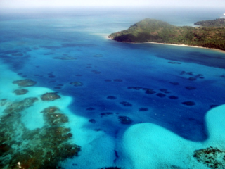
Morrocoy National Park is located on the easternmost coast of Falcón State and the northwest side of Golfo Triste, in the west central Venezuelan coast, near the towns of Boca de Aroa, Tucacas, Sanare, Chichiriviche, and Tocuyo de la Costa. It consists of 79,300 acres, and was declared a national park on May 26, 1974.
Great Pond is a 50 ha saline coastal lagoon on the south-eastern shoreline of the island of Saint Croix in the United States Virgin Islands. The pond is part of St Croix East End Marine Park. It the second largest salt pond in the Virgin Islands, and is one of the largest remaining mangrove tracts in St. Croix.

The Prickly Pear Cays, sometimes spelt as Prickley Pear Cays, are a small pair of uninhabited islands about six miles from Road Bay, Anguilla, in the Leeward Islands of the Caribbean. They are divided by a narrow boat channel between Prickly Pear East and Prickly Pear West. Prickly Pear Cays were classified as 'wildlands' by the "Eastern Caribbean Natural Area Management Programme" (ECNAMP). In addition, Prickly Pear Cays are one of six marine protected areas of Anguilla.

The fauna of the United States Virgin Islands consists of 144 species of birds, 22 species of mammals, 302 species of fish and 7 species of amphibians. The wildlife of the U.S.V.I. includes numerous endemic species of tropical birds, fish, and land reptiles as well as sea mammals. The only endemic land mammals are six species of native bats: the greater bulldog bat, Antillean fruit-eating bat, red fruit bat, Brazilian free-tailed bat, velvety free-tailed bat and the Jamaican fruit bat. Some of the nonnative land mammals roaming the islands are the white-tailed deer, small Asian mongoose, goats, feral donkeys, rats, mice, sheep, hogs, dogs and cats.

Solitary Islands Marine Park (SIMP) is a marine park in New South Wales State waters, Australia. It adjoins the Solitary Islands Marine Reserve and was declared under the Marine Parks Act 1997 (NSW) in January 1998. Prior to this it was declared a marine reserve in 1991. The Park was one of the first declared in NSW and stretches along the northern NSW coast, from Muttonbird Island, Coffs Harbour, to Plover Island near Sandon River, 75 kilometres to the north. It includes coastal estuaries and lakes and extends from the mean high water mark, to three nautical miles out to sea, covering an area of around 72,000 hectares. There are five main islands in the Park, North Solitary Island, North West Solitary Island, South West Solitary Island, South Solitary Island and Split Solitary Island, as well as other significant outcrops such as Muttonbird Island and submerged reefs.

Île Frégate is a small, uninhabited island in the Caribbean Sea located off the north coast of Saint Barthélemy, an overseas collectivity of France. Île Frégate is situated within the Nature Reserve of Saint Bartholomew, which was established in 1996 with the objective of conserving coral reefs, sea grass beds and marine life.
Saba Island is a rocky Caribbean island in the United States Virgin Islands, situated three miles south of Cyril E. King Airport on St. Thomas and 2.6 miles west of Water Island. It is a steep, 200 feet high island with a sandy beach on the northern side. Turtledove Cay is connected by a shallow sandbar. Saba Island has salt ponds on both the eastern and western sides, which is popular bird observation posts, and has numerous rocky cliffs with sea birds on its southern shores. Besides for bird observation, the island is visited by scuba divers and snorkelers. In addition to coral reefs, the waters here are home to numerous ship wrecks, such as the Witshoal II, Witconcrete II, Grainton, and Witservice IV.
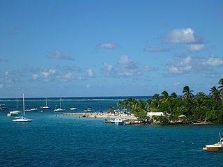
Protestant Cay is a four-acre triangular islet in the Christiansted Harbor, 200 yards north of Christiansted. The island is home to a resort, the Hotel on the Cay, which is home to a protected sand beach, small shop and beach bar. It also has the closest beach to Downtown Christiansted. With one of the ferries, which run from 7 a.m. to 12 a.m., every ten minutes, it will only take about two minutes to get there. The ride is free of charge after 4 p.m., and for guests of the Hotel on the Cay. To get on the ferry, passengers have to stand near the boardwalk in front of the King Christian Hotel and wave to the boat captain on duty.
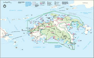
Henley Cay, previously known as Women's Cay, is an 11-acre tropical islet in the United States Virgin Islands. The cay is 300 yards in diameter and the largest and southernmost of the Durloe Cays in the Virgin Islands National Park. Henley Cay is situated 2,200 feet northwest of Turtle Bay on the island of Saint John, separated from the island by the Durloe Channel. The cay is 70 feet high and has a pier on its southern side, although it is uninhabited. The island is known as a snorkeling and kayaking destination, but is also visited for its white sandy beaches. Companies offer guided kayak tours from Cruz Bay, Honeymoon Bay, and Caneel Bay to Henley- and Lovango Cays.

East End is an administrative subdistrict of the island of St. Thomas in the United States Virgin Islands. The largest community is Red Hook, while smaller communities include Benner, Nazareth, Nadir, Frydendal, and Smith Bay. The subdistrict includes the offshore islands of Great Saint James, Little Saint James, Bovoni Cay, Patricia Cay, Cas Cay, Rotto Cay, Thatch Cay, Shark Island, and Dog Island.
Petite Terre Islands National Nature Reserve is a reserve of the Petite Terre Islands in Guadeloupe. The reserve was established by Decree No. 98-801 of 3 September 1998 as the nature reserve for the islands of Petite Terre. It covers an area of about 990 hectares, which is demarcated by five points fixed with buoys, and includes a land area of 148.6 hectares with the balance as sea area.
The St. Croix East End Marine Park (STXEEMP) was established to "protect territorially significant marine resources, and promote sustainability of marine ecosystems, including coral reefs, sea grass beds, wildlife habitats and other resources, and to conserve and preserve significant natural areas for the use and benefit of future generations." It is the U.S. Virgin Islands’ first territorially designated and managed marine protected area (MPA).
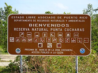
Reserva Natural Punta Cucharas is a nature reserve in Barrio Canas, Ponce, Puerto Rico. It consists of both a land area component as well as an offshore marine area. The land component has an area of 698 cuerdas while the marine component has an expanse of 3,516 cuerdas, for a total area of 4,214 cuerdas. The Reserve consists of mangrove ecosystems, coastal sand dunes, a saline lagoon known as Laguna Las Salinas, open water, and a century-old local community. The lagoon occupies and area of 347,898 m2 Ecological protection is managed and enforced by the Puerto Rico Department of Natural and Environmental Resources. Eight activities are allowed at the Reserve: scuba diving, boating, fishing, hiking, sun bathing, photography, bird watching and canoeing. Activities prohibited are: Camping, crabbing/trapping, horseback riding, water crafting, and hunting. Pets, ATVs, and fireplaces are also prohibited.
The Gales Point Wildlife Sanctuary is in the Belize District approximately 23.7 southwest of Belize City and 34 km north of Dangriga. The Sanctuary includes Southern Lagoon, Sapodilla Lagoon, Western Lagoon, Quashie Trap Lagoon and a portion of the Manatee river. It has a shoreline of 66-foot that is along all the lagoons and waterways except for the peninsula. The Wildlife Sanctuary covers a complex matrix of creeks, mangroves, mudflats and brackish lagoons. Both the rivers and creeks drains into the lagoon from the west. The lagoon is also connected to the Caribbean Sea via the Bar River.


