Cashelore

Last updated

Cashelore
Native name
Irish: Caisleán an Uabhair
Cashel Bir
Bawnboy
Ireland adm location map.svg
Red pog.svg
Location of Cashelore in Ireland
Typestone ringfort
LocationCastleore, Ballintogher,
County Sligo, Ireland
Coordinates 54°12′36″N8°22′39″W / 54.210069°N 8.377572°W / 54.210069; -8.377572 Coordinates: 54°12′36″N8°22′39″W / 54.210069°N 8.377572°W / 54.210069; -8.377572
Area500 m2 (5,400 sq ft)
Elevation49 m (161 ft)
Official name: Cashel Bir Stone Fort
Reference no.277.02

Cashelore, also called Cashel Bir or Bawnboy, is a stone ringfort (cashel) and National Monument located in County Sligo, Ireland. [1]

Contents

Location

Cashelore is located on the southern slopes of Benbo Mountain, 1.3 km (¾ mile) northwest of Ballintogher. [2]

History

Cashelore was built in the early Christian period (AD 400–1100). The name may mean "Fort Pride", while Cashel Bir is caiseal bir, "stone ringfort of stakes", presumably meaning that there was a palisade surrounding it, and Bawnboy is bábhún buidhe, "yellow walled enclosure." [3]

Skeletons were formerly found near the fort.

It is believed to be identical with Caislen-in-nuabhair, mentioned in the Annals of Loch Cé, entry for 1389:

Ó Ruairc subsequently brought the sons of Cathal Óg to him, and the war grew fierce after that. Eoghan O'Ruairc and the sons of Cathal Og went to Caislen-in-nuabhair, when the cavalry of Muintir hÉilidhe opposed them, and made an attack on them; and the son of Ó hÉilidhe was killed by them, together with Maghnus Ó hÉilidhe. Muintir hÉilidhe were plundered by O'Ruairc, and by the sons of Cathal Óg. Muirchertach Ó hÉilidhe was slain in this war. Maghnus Ó Ruairc was taken prisoner, per dolum, by Cormac Ó Fearghail. Peace was concluded by Ó Ruairc, and by Domhnall son of Muirchertach, and by the Clann-Donnchaidh, respectively. [4]

The O'Rourkes were kings of West Breifne (roughly County Leitrim), while the Ó hÉilidhe (Healys) were based around the Curlew Mountains, Ballinafad and the west of Lough Arrow. Per dolum is Latin for "by trickery." The Ó Fearghail ruled Angaile (roughly County Longford). [5]

Description

This is a stone ringfort 23 m (75 ft) long E-W and 16 m (52 ft) NS, with walls 3 m (9.8 ft) thick and 2.4 m (7 ft 10 in) high. [6]

A souterrain led to the bottom of the hill and could have functioned as an escape route. [7] [8]

Related Research Articles

Ruaidrí Ua Conchobair High King of Ireland

Ruaidrí mac Tairrdelbach Ua Conchobair was King of Connacht from 1156 to 1186, and High King of Ireland from 1166 to 1193. He was the last High King of Ireland before the Anglo-Normans invaded Ireland.

The Second Battle of Athenry took place at Athenry in Ireland on 10 August 1316 during the Bruce campaign in Ireland.

Toirdhealbhach Mór Ua Conchobhair anglicised Turlough Mór O'Connor / O'Conor, was King of Connacht (1106–1156) and High King of Ireland.

The Ó Duibhgeannáin clan were a family of professional historians in medieval and early modern Ireland.

Brian Luighneach Ua Conchobhair, Prince of Connacht, died 23 May 1181.

Grianan of Aileach fort in County Donegal, Ireland

The Grianan of Aileach is a hillfort atop the 244 metres (801 ft) high Greenan Mountain at Inishowen in County Donegal, Ireland. The main structure is a stone ringfort, thought to have been built by the Northern Uí Néill, in the sixth or seventh century CE; although there is evidence that the site had been in use before the fort was built. It has been identified as the seat of the Kingdom of Ailech and one of the royal sites of Gaelic Ireland. The wall is about 4.5 metres (15 ft) thick and 5 metres (16 ft) high. Inside it has three terraces, which are linked by steps, and two long passages within it. Originally, there would have been buildings inside the ringfort. Just outside it are the remains of a well and a tumulus.

Kingdom of Breifne former country

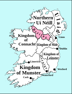
The Kingdom of Breifne or Bréifne was a medieval overkingdom in Gaelic Ireland. It comprised what is now County Leitrim, County Cavan and parts of neighbouring counties, and corresponds roughly to the Roman Catholic Diocese of Kilmore. It had emerged by the 10th century, as a confederation of túatha headed by an overking drawn from the Uí Briúin Bréifne.

Events from the year 1347 in Ireland.

Glangevlin Town in Ulster, Ireland

Glangevlin is situated in the northwest of County Cavan, Ireland, in the townlands of Gub (Glangevlin) and Tullytiernan, at the junction of the R200 and R207 regional roads. It is surrounded by the Cuilcagh Mountains and borders the counties of Leitrim and Fermanagh.

Ruaidrí Ua Conchobair, called Ruaidrí na Saide Buide was King of Connacht, perhaps twice.

Ballymagauran Village in Ulster, Ireland

Ballymcgovern is a village and townland in County Cavan, Ireland. It lies on the border with County Leitrim, within the parish of Templeport and barony of Tullyhaw on the Ballinamore to Ballyconnell road, the regional R205 road (Ireland).

Eaghra Poprigh mac Saorghus, eponym and ancestor of the clan Ó hEaghra, King of Luighne Connacht, died 928.

McGovern (name)

The surname McGovern, is of Irish origin and is found predominantly in the counties of Cavan, Fermanagh and Leitrim.

Tomás mac Brian Breaghach Mág Samhradháin, was chief of the McGovern Clan and Baron or Lord of Tullyhaw barony, County Cavan from before 1325 until his death in 1340.

Niall Mag Samhradháin, was chief of the McGovern Clan and Baron or Lord of Tullyhaw barony, County Cavan from 1340 until his death in 1359.

Maghnus Ruadh Mág Samhradháin, the Second, was chief of the McGovern Clan and Baron or Lord of Tullyhaw barony, County Cavan from 1393 until his murder in 1408.

Macraith Mág Tighearnán was chief of the McKiernan Clan and Baron or Lord of Tullyhunco barony, County Cavan from c.1240 until his death in 1258.

Cú Connacht Mág Tighearnán was chief of the McKiernan Clan of Tullyhunco, County Cavan from 1383 until his death in 1412.

Cashelmore stone ringfort in County Sligo, Ireland

Cashelmore, also called Clogher Stone Fort, is a stone ringfort (cashel) and National Monument located in County Sligo, Ireland.

Seltanahunshin is a townland in the civil parish of Oughteragh, barony of Carrigallen, County Leitrim, Ireland.

References

  1. http://www.sligococo.ie/media/CouncilDownloads/Planning/Media,1935,en.pdf [ dead link ]
  2. Gerrard, David (1 January 2004). The Hidden Places of Ireland. Travel Publishing Ltd. ISBN   9781904434108 via Google Books.
  3. Greenwood, Margaret; Connolly, Mark; Wallis, Geoff (1 January 2003). Ireland. Rough Guides. ISBN   9781843530596 via Google Books.
  4. "Part 2 of Annals of Loch Cé".
  5. Woulfe, Patrick. "Ó hÉilidhe".
  6. Milligan, Seaton Forrest; (L.), Alice Milligan (1 January 1888). "Glimpses of Erin: Containing an Account of the Ancient Civilisation, Manners, Customs, and Antiquities of Ireland: Short Sketches of the More Important Events in History, and of the Social Condition of the Country, Past and Present; and Papers on Tours Off the Beaten Track ..." M. Ward & Company, Limited via Google Books.
  7. Wood-Martin, William Gregory (1 January 1888). "The Rude Stone Monuments of Ireland. (Co. Sligo and the Island of Achill.)". Hodges, Figgis, & Company via Google Books.
  8. "Archaeology in Sligo - FunThings to do in Sligo - Sligo Southern Hotel". Archived from the original on 6 October 2016. Retrieved 5 October 2016.