
Dorset is a ceremonial county in South West England. It is bordered by Somerset to the north-west, Wiltshire to the north and the north-east, Hampshire to the east, the Isle of Wight across the Solent to the south-east, the English Channel to the south, and Devon to the west. The largest settlement is Bournemouth, and the county town is Dorchester.

Corfe Castle is a village and civil parish in the English county of Dorset. It is the site of a ruined castle of the same name. The village and castle stand over a gap in the Purbeck Hills on the route between Wareham and Swanage. The village lies in the gap below the castle and is around four miles (6.4 km) south-east of Wareham, and four miles (6.4 km) north-northwest of Swanage. Both the main A351 road from Lytchett Minster to Swanage and the Swanage Railway thread their way through the gap and the village.

Poole is a coastal town and seaport on the south coast of England in the Bournemouth, Christchurch and Poole unitary authority area in Dorset, England. The town is 21 miles (34 km) east of Dorchester and adjoins Bournemouth to the east. Since 1 April 2019, the local authority is Bournemouth, Christchurch and Poole Council. The town had an estimated population of 151,500 making it the second-largest town in the ceremonial county of Dorset. Together with Bournemouth and Christchurch, the conurbation has a total population of nearly 400,000.

Studland is a village and civil parish on the Isle of Purbeck in Dorset, England. The village is located about 2 miles (3.2 km) north of the town of Swanage, over a steep chalk ridge, and 3 miles (4.8 km) south of the South East Dorset conurbation at Sandbanks, from which it is separated by Poole Harbour. The parish includes Brownsea Island within the harbour. In the 2011 census the parish had 182 households and a population of 425, though many of the houses in the village are holiday homes, second homes, or guest houses, and the village's population varies depending upon the season.
The Isle of Purbeck is a peninsula in Dorset, England. It is bordered by water on three sides: the English Channel to the south and east, where steep cliffs fall to the sea; and by the marshy lands of the River Frome and Poole Harbour to the north. Its western boundary is less well defined, with some medieval sources placing it at Flower's Barrow above Worbarrow Bay. John Hutchins, author of The History and Antiquities of the County of Dorset, defined Purbeck's western boundary as the Luckford Lake stream, which runs south from the Frome. According to writer and broadcaster Ralph Wightman, Purbeck "is only an island if you accept the barren heaths between Arish Mell and Wareham as cutting off this corner of Dorset as effectively as the sea." The most southerly point is St Alban's Head.
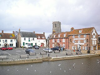
Wareham is a historic market town and, under the name Wareham Town, a civil parish, in the English county of Dorset. The town is situated on the River Frome eight miles (13 km) southwest of Poole.

Corfe Mullen is a village in Dorset, England, on the north-western urban fringe of the South East Dorset conurbation. The community had a population of 10,133 at the 2011 Census. It is served by six churches, four pubs, five schools, a library, various shops and local businesses, a village hall, and many community and sports organisations. On 10 December 2019 The Corfe Mullen Parish Council resolved to adopt Town Council status, citing potential financial benefits. In all other aspects Corfe Mullen is still very much a village, albeit a large one.

Dorset is a rural county in south west England. Its archaeology documents much of the history of southern England.

Poole Grammar School is an 11–18 selective boys grammar school and academy in the coastal town of Poole in Dorset, on the south coast of England. It is a member of the South West Academic Trust (SWAT). The school was a mathematics and computing school, with an additional specialism, cognition, added in 2006.

Broadstone is a suburb of Poole in Dorset, England. It is located 3 miles (4.8 km) from Hamworthy railway station and 7 miles (11 km) from Bournemouth International Airport. The ward had a population of 10,303 at the 2011 Census, increasing from 10,256 at the 2001 Census.

Corfe Hills School is a co-educational upper school in Broadstone, Poole, Dorset, England, in the urban fringe between Poole and Wimborne. The school became an academy in 2011. The school serves Corfe Mullen, Broadstone, Wimborne, Merley and Sturminster Marshall. The current headteacher is James Sankey.

Beacon Hill is one of the highest viewpoints in the hinterland of Poole Harbour, Dorset. Its tree-covered summit reaches 84 metres (276 ft) above sea level and there is a public footpath running roughly north to south over the top. Historically it was one of a series of beacons used to warn of the advancing Spanish Armada. The earlier name for the hill was Lytchett Beacon.
Barrow Hill is a small settlement in Dorset, England, situated in the East Dorset administrative district on the A350 road approximately 4 miles (6.4 km) northwest of Poole. It lies between Lytchett Matravers and Corfe Mullen, though is in the civil parish of Sturminster Marshall.

Wilts & Dorset was a bus and coach operator providing services in East Dorset, South Wiltshire and West Hampshire. It was purchased by Go-Ahead Group in 2003 and was rebranded as Morebus in Dorset and Salisbury Reds in Wiltshire in 2012.

Corfe Castle is a fortification standing above the village of the same name on the Isle of Purbeck peninsula in the English county of Dorset. Built by William the Conqueror, the castle dates to the 11th century and commands a gap in the Purbeck Hills on the route between Wareham and Swanage. The first phase was one of the earliest castles in England to be built at least partly using stone when the majority were built with earth and timber. Corfe Castle underwent major structural changes in the 12th and 13th centuries.

Stoney Down or Stony Down is both a hill and an area of forested countryside in the county of Dorset, England, that has been designated an "Area of Great Landscape Value" (AGLV) in the East Dorset Local Plan. The forest is known as the Stoney Down Plantation or Stony Down Plantation. It covers an area of 51.13 hectares. The area is popular with riders and walkers.


