
Shaftesbury is a town and civil parish in Dorset, England. It is situated on the A30 road, 20 miles west of Salisbury, near the border with Wiltshire. It is the only significant hilltop settlement in Dorset, being built about 215 metres above sea level on a greensand hill on the edge of Cranborne Chase.

Kimmeridge is a small village and civil parish on the Isle of Purbeck, a peninsula on the English Channel coast in Dorset, England. It is situated about 4.5 miles (7.2 km) south of Wareham and 7 miles (11 km) west of Swanage. In 2013 the estimated population of the civil parish was 90.

Studland is a village and civil parish on the Isle of Purbeck in Dorset, England. The village is located about 2 miles (3.2 km) north of the town of Swanage, over a steep chalk ridge, and 3 miles (4.8 km) south of the South East Dorset conurbation at Sandbanks, from which it is separated by Poole Harbour. The parish includes Brownsea Island within the harbour. In the 2011 census the parish had 182 households and a population of 425, though many of the houses in the village are holiday homes, second homes, or guest houses, and the village's population varies depending upon the season.

East Dorset was a local government district in Dorset, England. Its council met in Wimborne Minster between 2016 and 2019.

Purbeck was a local government district in Dorset, England. The district was named after the Isle of Purbeck, a peninsula that forms a large proportion of the district's area. However, it extended significantly further north and west than the traditional boundary of the Isle of Purbeck which is the River Frome. The district council was based in the town of Wareham, which is itself north of the Frome.

Corfe Mullen is a village in Dorset, England, on the north-western urban fringe of the South East Dorset conurbation. The village had a population of 10,133 at the 2011 Census. It is served by six churches, four pubs, five schools, a library, various shops and local businesses, a village hall, and many community and sports organisations. On 10 December 2019 The Corfe Mullen Parish Council resolved to adopt Town Council status, citing potential financial benefits. In all other aspects Corfe Mullen is still very much a village, albeit a large one.
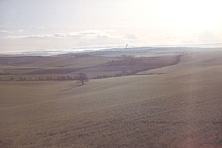
The Dorset Downs are an area of chalk downland in the centre of the county Dorset in south west England. The downs are the most western part of a larger chalk formation which also includes Cranborne Chase, Salisbury Plain, Hampshire Downs, Chiltern Hills, North Downs and South Downs.
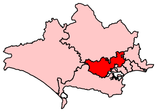
Mid Dorset and North Poole is a constituency represented in the House of Commons of the UK Parliament since 2015 by Michael Tomlinson, a Conservative.
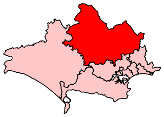
North Dorset is a constituency represented in the House of Commons of the UK Parliament since 2015 by Simon Hoare, a Conservative.

Djursland is a 44 km × 33 km hilly lowland peninsula in Denmark at the entrance to the Baltic Sea, between Denmark and Sweden in Northern Europe. Djursland protrudes into the Kattegat sea, as part of the larger peninsula of Jutland, which itself extends from the Central European continent. Djursland comprises the two municipalities of Norddjurs and Syddjurs.

The West Pennine Moors is an area of the Pennines covering approximately 90 square miles (230 km2) of moorland and reservoirs in Lancashire and Greater Manchester, England. It is a Site of Special Scientific Interest.

Wareham railway station serves the town of Wareham in Dorset, England. It is situated about 0.6 miles (1 km) north of the town centre. It is 120 miles 70 chains (194.5 km) down the line from London Waterloo. On tickets it is printed "Wareham Dorset" to avoid confusion with Ware railway station.

Beacon Hill is one of the highest viewpoints in the hinterland of Poole Harbour, Dorset. Its tree-covered summit reaches 84 metres (276 ft) above sea level and there is a public footpath running roughly north to south over the top. Historically it was one of a series of beacons used to warn of the advancing Spanish Armada. The earlier name for the hill was Lytchett Beacon.

Upton Heath is one of the largest remaining fragments of a heath that once stretched across central southern England from Dorchester to Christchurch and beyond. Today it is confined to an area immediately west of Upton and Poole, much of which is protected. From the Heath there are views across Poole Harbour, Corfe Castle and the Isle of Purbeck.
At 248 metres (814 ft), Dogbury Hill is one of the highest hills in the county of Dorset, England. It is the site of a prehistoric hill fort.

The Dorset Heaths form an important area of heathland within the Poole Basin in southern England. Much of the area is protected.

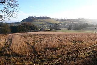
The Stonehill Down Nature Reserve is a downland nature reserve on the Purbeck Hills in the county of Dorset, England. It is managed by the Dorset Wildlife Trust.

Mols Bjerge National Park or Nationalpark Mols Bjerge is a Danish national park in the area known as Mols Bjerge in Syddjurs Municipality, Central Jutland, inaugurated on 29 August 2009. The protected area, measures 180 square kilometres (69 sq mi) in size. The Mols Hills, reaching a height of 137 metres (449 ft), are centrally located in the park, and take up 2,500 ha. "More than half of all wild Danish plant species" can be found at Mols Bjerge.

Castle Court School is a co-educational, preparatory school located near the village of Corfe Mullen in the county of Dorset, England.

