Castle Frankenburg

Last updated
Castle Frankenburg
Feste Frankenburg
Frankenburg am Hausruck, Austria
Frankenburg Vischer.jpg
Frankenburg (in ruins depicted on the top right corner) after an engraving by Georg Matthäus Vischer from 1674 "Topographia Austriae superioris modernae"
Austria adm location map.svg
Red pog.svg
Castle Frankenburg
Coordinates 48°5′9″N13°30′2″E / 48.08583°N 13.50056°E / 48.08583; 13.50056
TypeCastle
Site history
BuiltUnknown. First mentioned in documents dated 1160.


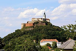
Castle Frankenburg, formerly known as Feste Frankenburg, in German, or Francoburgum Castrum, in Latin, is an abandoned hilltop castle in the municipality of Frankenburg am Hausruck in Upper Austria on the Hofberg hilltop, [1] formerly Am Vogl. It was first mentioned in a document in 1160 and abandoned as an administrative centre in 1511. The area is used for hiking, with the 'Hofberghütte' on the site of the former castle serving as a vantage point. [2]

Contents

Location

Frankenburg was located on the Upper Austrian side of the old Bavarian border. As the division of territory was not yet secure at the time, it is often counted as part of the Bavarian territory in historical accounts. In addition to protecting the citizens, the aim was also to secure the border to the north.

The castle was built on a plateau at an altitude of around 723 metres. The former cemetery is also located on the Hofberg. Over the course of time, human remains were found in various places during excavations. No ruins are recognisable on the surface today. After it was abandoned, it served as a source of stone for the local population. In the 16th century, fires were even lit to make it easier to obtain building materials. The high proportion of wood was also partly responsible for the severe decay.

History

The first medieval estate was built in the area of the village church, but no traces of it can be found today. The subsequent building was erected on the Hofberg, where archaeological excavations (2003 and 2005) brought fragments of the wall to light. Today's market town of Frankenburg was still known as Zwispallen at the time. There is also evidence of Celtic graves in the vicinity of the castle. These suggest the existence of a previous, even older castle complex.

In the course of the settlement of the area around Zwispallen, the need for defences arose. The first Frankish immigrants cleared the wooded Hofberg. The surrounding settlements had various functions, which can also be seen in their names, e.g. Pehigen (formerly also Bechigen, from Pechsieder) or Badstuben. The local settlers built the defences themselves. In the second half of the 11th century, Rappoto von Julbach was commissioned by the nobility to complete the Frankenburg fortress. This is why Frankenburg Castle was very similar to the castle in Julbach. [3] The builders continued the work of the settlers with stone. The Frankenburg was largely made of wood, but finds show that it was not completely wooden.

During the first expansion phase, the people of Julbach forced the unfree peasants around the Frankenburg castle to perform bonded labour. The region belonged to the bishopric of Bamberg (Bavaria), which disapproved of the exploitation of the settlers' property. Their aim was to run the forestry in Frankenburg.

Frankenburg Castle was later extended from a purely defensive castle to an administrative castle (Vogteiburg). Some of the additional buildings were also constructed with bricks. The building was completed under Otto I in the 12th century. In a letters patent, Emperor Frederick Barbarossa officially confirmed the 'fortress' of Frankenburg and its goods to his successor. With this confirmation, the castle could also be lent, pledged or given away. The emperor's demand in the same document that he be given a say in the allocation of bailiwicks also increased the political significance of the castle. On 15 February 1160, the fortress is also referred to as Francoburgum castrum for the first time. [2]

A decade later (1170), Engelschalk von Reit handed over Zwispallen and with it the castle to Asbach Abbey. Until 1438, Frankenburg was nevertheless subject to the supreme authority of the Bamberg diocese. The monastery was also the owner of various estates, which had to pay taxes. Such donations were intended to pave the way for the founders into the afterlife. [3]

In 1581, Emperor Rudolf II granted his envoy in Madrid, Hans Khevenhüller, the dominions of Frankenburg (with the then still intact seat of Frankenburg Castle) and Frein Castle, as well as the dominions of Kogl Castle (where the Khevenhüllers built Kogl Castle in 1750) and Kammer Castle, which were united to form the 'County of Frankenburg' in 1593.

Ruins

Remains of the wall were found at the front, but they are too thin to have been part of the tower. During the excavation at the beginning of the 21st century, many everyday objects were found. These included piles of medieval nails, which indicate the presence of wooden structures at this location.

During excavations in 2007, a brick with the fingerprints of a labourer was also found. Investigations show that the man, who was about 156 cm tall, was right-handed. The searchers also unearthed fragments of pottery, almost half of which were made of light-coloured pottery known as 'Hausruck pottery'. Some of the ceramics are stamped or have border motifs, and some bear wheel crosses, an early form of marking ceramic ware. This light-coloured pottery is rather rare in contrast to the dark-coloured pottery.

One special find was a ceramic mouthpiece made of light-coloured clay. Instruments of this type are not usually preserved, but this broken piece can still be used to elicit sounds today.

Collections of old oven tiles were found in two different places, including one decorated with a winged griffin from the 15th century, together with charred animal bones. These ovens were either used as a cooking area or the castle inhabitants threw rubbish into the fire. However, the tiles were not made to a high standard, they are very coarse-grained. Furthermore, part of a brick floor was found above a thick layer of fire debris. The traces of fire are evidence of various fires in the castle, which affected all parts.

Reconstruction of the plant

Castle's stable ruins on the Hofberg hilltop. Frankenburg am Hausruck ehemalige Burg.JPG
Castle's stable ruins on the Hofberg hilltop.

The castle measured 302 metres from north to south, of which the castle plateau and outer bailey accounted for around 150 metres. The main castle was 74 metres long and a maximum of 32 metres wide. The path up the Hofberg, which is still used today (for agricultural purposes), leads to the historic entrance. This was followed by two ramparts that could be passed through gates. The ramparts were a maximum of six metres high. A small square was then reached, from which the first moat could be crossed via a bridge. Those seeking entry then reached the outer bailey. The main bridge led over the main moat to the main castle. Today's ground structure still clearly shows the plateaus and moats. The remains of the outer wall have been preserved; it was around 120 cm thick. The inner walls, on the other hand, were only around 37 cm thick. Remains of a defence wall are also still present. The keep was completely demolished towards the end of the Middle Ages. However, a surface measurement revealed an original size of around 9 × 9 metres. A painting in Hochosterwitz Castle clearly shows the old tower. It can be seen that it consisted of at least two upper storeys, which corresponds to a height of 25 to 30 metres. [2]

The reconstruction was based on old paintings, ground measurements and excavations. An extensive archaeological excavation would probably provide more precise information, but is currently (2010) not feasible.

Related Research Articles

<span class="mw-page-title-main">Königsburg</span> Ruined medieval castle

The Königsburg is a ruined medieval castle southeast of Königshütte, a village in the borough of Oberharz am Brocken, in Harz district in the German state of Saxony-Anhalt.

<span class="mw-page-title-main">Belvoir Castle (Israel)</span> Crusader castle in northern Israeli

Belvoir Castle, also called Coquet by the Crusaders, also Kochav HaYarden and Kawkab al-Hawa, is a Crusader castle in northern Israel, on a hill on the eastern edge of the Issachar Plateau, on the edge of Lower Galilee 20 kilometres (12 mi) south of the Sea of Galilee. Gilbert of Assailly, Grand Master of the Knights Hospitaller, began construction of the castle in 1168. The castle ruin is located in Belvoir National Park, officially Kochav HaYarden National Park. It is the best-preserved Crusader castle in Israel.

<span class="mw-page-title-main">Ir Ovot</span> Village in southern Israel

Ir Ovot is a small village in southern Israel. Located in the northeastern Arabah, it falls under the jurisdiction of Central Arava Regional Council. It operated as a kibbutz from 1967 until the 1980s. In 2019 it had a population of 54.

<span class="mw-page-title-main">Teishebaini</span> Archaeological site near Yerevan, Armenia

Teishebaini was the capital of the Transcaucasian provinces of the ancient kingdom of Urartu. It is located near the modern city of Yerevan in Armenia. The site was once a fortress and governmental centre with towered and buttressed perimeter walls, massive gates, a parade ground within its walls, and storage rooms that entirely occupied the ground floor. The site of the city, palace and citadel together measure over 0.45 km2. The name Karmir Blur translates to "Red Hill" because of the hill's reddish hue. It became this color after the city was set on fire and the upper walls which were made of tuff fell and crumbled because of the heat. After the tuff was heated by the fire, it took on a more intense red color and therefore the hill became red. The lower portions of the walls were left standing after the fire since they were built with a stronger stone. Teishebaini is situated at a height of 901 metres (2,956 ft).

<span class="mw-page-title-main">Pevensey Castle</span> Castle in East Sussex, England

Pevensey Castle is a medieval castle and former Roman Saxon Shore fort at Pevensey in the English county of East Sussex. The site is a scheduled monument in the care of English Heritage and is open to visitors. Built around 290 AD and known to the Romans as Anderitum, the fort appears to have been the base for a fleet called the Classis Anderidaensis. The reasons for its construction are unclear; long thought to have been part of a Roman defensive system to guard the British and Gallic coasts against Saxon pirates, it has more recently been suggested that Anderitum and the other Saxon Shore forts were built by a usurper in an ultimately unsuccessful attempt to prevent Rome from reimposing its control over Britain.

<span class="mw-page-title-main">Acciano</span> Comune in Abruzzo, Italy

Acciano is a comune in the Province of L'Aquila in the Abruzzo region of Italy. The small, medieval village is in the Subequana valley and is a part of the Sirentina Mountain Community.

<span class="mw-page-title-main">Frankenburg am Hausruck</span> Place in Upper Austria, Austria

Frankenburg am Hausruck is a municipality in the district of Vöcklabruck in the Austrian state of Upper Austria.

<span class="mw-page-title-main">Circular rampart</span> Embankment built in the shape of a circle

A circular rampart is an embankment built in the shape of a circle that was used as part of the defences for a military fortification, hill fort or refuge, or was built for religious purposes or as a place of gathering.

<span class="mw-page-title-main">Irgenhausen Castrum</span> Former Roman fort in Irgenhausen, Switzerland

Irgenhausen Castrum is a Roman fort at Irgenhausen, situated on Pfäffikersee lake shore in Switzerland. It was a square fort, measuring 60 metres (197 ft) in square, with four corner towers and three additional towers. The remains of a stone wall in the interior were probably a spa.

<span class="mw-page-title-main">Calenberg Castle</span> Castle ruins in Lower Saxony, Germany

Calenberg Castle was a medieval lowland castle in central Germany, near Schulenburg in the borough of Pattensen, 13 kilometres (8.1 mi) west of the city of Hildesheim. It was built as a water castle in 1292 by the Welf duke, Otto the Strict, in der Leine river meadows between two branches of the Leine river on the southern part of the chalk marl hill of the Calenberg. At the start of the 16th century it was converted into a fort (Feste). In the 15th century, Fort Calenberg gave its name to the Welf Principality of Calenberg. Following the Thirty Years' War it lost its military importance and was slighted. Today it is a ruin with underground vaults that are surrounded by high ramparts.

<span class="mw-page-title-main">Amelungsburg (Süntel)</span>

The Amelungsburg is a former ringfort that is located on the Amelungsberg hill on the Süntel ridge in the district of Hameln-Pyrmont in the German state of Lower Saxony.

<span class="mw-page-title-main">Late Antiquity and Medieval sites in Kosovo</span>

Part of series of articles upon Archaeology of Kosovo

<span class="mw-page-title-main">Frankenburg (Palatinate)</span>

The Frankenburg is a natural monument with the ruins of a rock castle in the county of Südliche Weinstraße in the German state of Rhineland-Palatinate. It lies above the Modenbach valley on a rocky outcrop of the Frankenberg called the Frankenfelsen and was built to guard the road opposite Meistersel Castle.

<span class="mw-page-title-main">Neideck Castle</span> Castle in Germany

Neideck Castle is a former high mediaeval nobleman's castle above the village of Streitberg, in the municipality of Wiesenttal in the Upper Franconian county of Forchheim in the German state of Bavaria. As a result of its exposed location above the valley of the Wiesent, it has become a symbol of Franconian Switzerland.

The burgstall of Dietrichstein Castle, also called the Diederichstein Ruins, is the site of an old, probably high mediaeval, aristocratic, castle, situated high above the valley of the River Trubach in the municipality of Pretzfeld in the Upper Franconian county of Forchheim in Bavaria, Germany.

<span class="mw-page-title-main">Medieval Louvre Castle</span> Demolished castle in Paris, France

The Louvre Castle, also referred to as the Medieval Louvre, was a castle begun by Philip II of France on the right bank of the Seine, to reinforce the city wall he had built around Paris. Over time it was expanded but was generally demolished above ground in stages between 1528 and 1660 to make way for expanding the Louvre Palace, while some parts of the castle's foundations were incorporated in construction of the later palace.

<span class="mw-page-title-main">Holter Burg</span>

The Holter Burg is the oldest castle site in the municipality of Bissendorf near Osnabrück in the German state of Lower Saxony. It is the ruin of a hill castle. It was the third hill castle in Osnabrück Land along with the Iburg and the Wittekindsburg near Rulle.

<span class="mw-page-title-main">Tancred's Tower</span> Former tower in Jerusalems Old City walls

Tancred's Tower, known in Arabic as Qasr (al-)Jalud, was a large tower at the northwest corner of the Old City of Jerusalem, of which only meager remains were unearthed by archaeologists.

<span class="mw-page-title-main">Frein Castle</span> Historic site in Vöcklabruck, Upper Austria

Frein Castle is located in the Frein division of the municipality of Frankenburg am Hausruck in the Vöcklabruck district of Upper Austria.

<span class="mw-page-title-main">Pinxton Castle</span> Archaeological site in Between Pinxton and South Normanton, Derbyshire

Pinxton Castle, Derbyshire, is a scheduled monument in Castle Wood that straddles Pinxton and South Normanton. In its designation as a scheduled monument, Historic England describes it as having been a motte and fortified manor, with a moated site and five fishponds. Unlike most of the about 6000 moated sites in England, a large, fortified enclosure surrounded the moat.

References

  1. "Wechselvolle Geschichte mit Weitblick". nachrichten.at (in German). Retrieved 2024-09-01.
  2. 1 2 3 Ottinger, Franz (2008). Die Frankenburg: Geschichte der "Frankenburg" und der Versuch einer Rekonstruktion der Feste auf dem Hofberg. Edition Heimatgeschichte. Ried im Innkreis: Moserbauer. ISBN   978-3-902121-91-2.
  3. 1 2 Kaiser, Martin (2021). 400 Jahre Markt Frankenburg 1621-2021. Linz: Heimatverein Frankenburg. ISBN   9783950290141.