Androusa is a village and a former municipality in Messenia, Peloponnese, Greece. Since the 2011 local government reform it is part of the municipality Messini, of which it is a municipal unit. The municipal unit has an area of 50.514 km2. Predominantly a farming region, the principal exports include kalamata olives, olive oil, and livestock. It is located 22 km north-west of the regional capital Kalamata. Municipal unit population 1,800 (2021), village population 522 (2021).
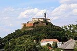
Celje Castle, also known as Celje Upper Castle or Old Castle, is a castle ruin in Celje, Slovenia, formerly the seat of the Counts of Celje. It stands on three hills to the southeast of Celje, where the river Savinja meanders into the Laško valley. Today, the castle is in the process of being restored. It was once the largest fortification on Slovenian territory.

Finkenstein Castle is a ruined medieval castle in the market town of Finkenstein, in the Austrian state of Carinthia. It is situated on a steep cliff at the southern foot of the Karawanks mountain range, high above Lake Faak, at a height of 788 metres (2,585 ft). Today the castle ruin is the backdrop of the Burgarena, an amphitheatre with 1150 seats mainly used for concerts and festivals.

Burgruine Hardegg is a small Romanesque twin castle complex on a wooded hill north of the town of Zweikirchen in Carinthia, Austria. Nearby are the ruins of Liebenfels, Gradenegg and Liemberg, which, together with Hardegg, were among the main castles in the castle ring that surrounded the ducal capital of St. Veit.

Prägrad Castle is a ruined medieval castle in Carinthia, Austria. It is located near Feldkirchen on a hillside above the road to Lake Ossiach.

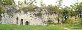
Burgruine Steuerberg is the ruins of a castle near Feldkirchen in Carinthia, Austria; 779 metres (2,556 ft) above sea level.

Aggstein Castle is a ruined castle on the right bank of the Danube in Wachau, Austria. The castle dates to the 12th century. Aggstein Castle is 480 metres (1,570 ft) above sea level.

Dürnstein Castle is the ruin of a medieval rock castle in Austria. It is located in Dürnstein, in the Lower Austrian Wachau region on the Danube river, at 312 metres (1,024 ft) above sea level.

Burg Krems is a castle in Styria, Austria. Burg Krems is 330 metres (1,080 ft) above sea level.

Burgruine Steinschloß is a castle in Styria, Austria.
Scharzfels Castle is the medieval ruin of a fortification located east of the village of Scharzfeld in the borough of Herzberg am Harz in central Germany. It lies in a wood on a ridge about 150 m above the Oder valley. For centuries after its construction in the 10th or 11th century it remained an impregnable fortress. The inner ward is built on a dolomite rock outcrop about 20 m high. The castle was first captured after a siege in 1761 during the Seven Years' War and then blown up.

The Wachau is an Austrian valley with a picturesque landscape formed by the Danube river. It is one of the most prominent tourist destinations of Lower Austria, located midway between the towns of Melk and Krems that also attracts "connoisseurs and epicureans" for its high-quality wines. It is 36 kilometres (22 mi) in length and was already settled in prehistoric times. A well-known place and tourist attraction is Dürnstein, where King Richard I of England was held captive by Leopold V, Duke of Austria. The architectural elegance of its ancient monasteries, castles and ruins combined with the urban architecture of its towns and villages, and the cultivation of vines as an important agricultural produce are the dominant features of the valley.

Burgruine Landsee is a ruined castle located in the middle of the Austrian state of Burgenland, east of the village of Landsee in the Markt Sankt Martin municipality in the Oberpullendorf district. It is one of the largest castle ruins in Central Europe. Burgruine Landsee stands 537 metres (1,762 ft) above sea level.

Greifenstein Castle is a ruined castle in the municipality of Filisur of the Canton of Graubünden in Switzerland. It is included on the register of the Swiss Inventory of Cultural Property of National and Regional Significance.

Rottenegg Castle is a ruined castle near the village of Rottenegg in the municipality of Sankt Gotthard im Mühlkreis, Austria. It dates to the 13th century, and was built to protect a medieval trade route. After 1712 the castle was allowed to decay, and much of it has disappeared.

Scherenburg Castle is a ruined hill castle at an elevation of 200 m above sea level (NN) which stands on a hillside above the town of Gemünden am Main in the province of Lower Franconia in the German state of Bavaria.

Grenzau Castle is a ruined spur castle at 250 m above sea level (NN) near Höhr-Grenzhausen in the county of Westerwaldkreis in the state of Rhineland-Palatinate. It is the only castle in Germany with a triangular bergfried.

Neideck Castle is a former high mediaeval nobleman's castle above the village of Streitberg, in the municipality of Wiesenttal in the Upper Franconian county of Forchheim in the German state of Bavaria. As a result of its exposed location above the valley of the Wiesent, it has become a symbol of Franconian Switzerland.

On a hill spur above the Eifel village of Monreal in Germany's Elzbach valley, at a height of 350 m above sea level (NHN), stand two neighbouring ruined hill castles: the Löwenburg, also called Monreal Castle, and the Philippsburg. The latter is also known locally as das Rech.

Hohenrechberg Castle is a ruined castle in Schwäbisch Gmünd in Baden-Württemberg, Germany. It was built as a spur castle on the spur of the Hohenrechberg mountain, which forms together with the Hohenstaufen Mountain and Stuifen the Three Emperors Mountains, just a few kilometers next to the family seat Hohenstaufen castle of the Staufer dynasty.