You can help expand this article with text translated from the corresponding article in German. (July 2009)Click [show] for important translation instructions.
|
Golling Castle | |
---|---|
Burg Golling | |
Golling an der Salzach, Salzburg, Austria | |
Type | Hill castle |
Height | 469 metres (1,539 ft) |
Site information | |
Open to the public | Yes |
Condition | Preserved |
Site history | |
Built | 13th century |
Built by | Prince-archbishops of Salzburg |
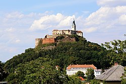
Burg Golling is a castle in Golling an der Salzach, in the Austrian state of Salzburg, erected by the Prince-Archbishops of Salzburg in the 13th century. The large fortress is located on a rock above the Salzach valley near the strategically important narrows between the Hagen and Tennen Mountains, at 469 metres (1,539 ft) above sea level. [1]
Salzburg is an Austrian federal state. In German it is called a Bundesland, a German-to-English dictionary translates that to federal state and the European Commission calls it a province. In German, its official name is Land Salzburg, to distinguish it from its eponymous capital Salzburg. For centuries, it was an independent Prince-Bishopric of the Holy Roman Empire. It borders Germany & Italy.
Hohenwerfen Castle is a medieval rock castle, situated at an altitude of 623 metres (2,044 ft), on a 155-metre (509 ft) rock pillar overlooking the Austrian market town of Werfen in the Salzach valley, approximately 40 kilometres (25 mi) south of Salzburg. The fortress is surrounded by the Berchtesgaden Alps and the adjacent Tennen Mountains. Hohenwerfen is a "sister" of Hohensalzburg Fortress, both built by the Archbishops of Salzburg in the 11th century.
The Bezirk Hallein is an administrative district (Bezirk) in the federal state of Salzburg, Austria, and congruent with the Tennengau region.
Golling an der Salzach is a market town in the Hallein district of Salzburg, Austria.
Kuchl is a market town in the Hallein district of Salzburg, Austria.
The Arenberg Castle is a castle on the right bank of the river Salzach in Salzburg.
The Lammer is a river of Salzburg, Austria, a right tributary of the Salzach.
Aigen is a district in the city of Salzburg, Salzburgerland, Austria and is known as one of the most expensive residential areas of the provincial capital. It is one of the 24 districts in which Salzburg is organized. The Salzach river is its western border and the municipality of Elsbethen is to the south. Many celebrities such as the Families Porsche and Piech, Franz Beckenbauer, Renate Thyssen-Henne, DJ Ötzi and others live in Aigen.
The Salzkammergut Mountains are a mountain range of the Northern Limestone Alps, located in the Austrian states of Salzburg and Upper Austria. They are named after the Salzkammergut historic region, part of the Hallstatt-Dachstein / Salzkammergut Cultural Landscape UNESCO World Heritage Site.
Finstergrün Castle is a castle in the state of Salzburg, Austria. Burg Finstergrün is 1,087 metres (3,566 ft) above sea level. The castle is believed to have been built in 1296/97 by Rudolf von Fohnsdorf. In 1300 it was described as “a border fortress” between the Archbishopric of Salzburg and the Duchy of Styria. During the 14th and 15th centuries it became the seat of the administrator who was in charge of managing the silver mines in Ramingstein. The first documented mention of the name Burg Finstergruen occurred in 1629.
Moosham Castle is a medieval castle near Unternberg in the Lungau region of Salzburg, Austria. The spur castle is situated at a height of 1,079 metres (3,540 ft).
Saalegg Castle is a ruined castle in the state of Salzburg, Austria.
The Historic Centre of the City of Salzburg, also known as the Altstadt, is a district of Salzburg, Austria, recognized as UNESCO World Heritage Site since 1996. It corresponds with the historic city center, situated on the left and right banks of the Salzach river.
The Ahornbüchsenkopf is a northern subpeak of the Hoher Göll, 1,604 m above sea level (NN) high, in the Berchtesgaden Alps in the county of Berchtesgadener Land, Bavaria, Germany, and the state of Salzburg in Austria.
The Hoher Göll is a 2,522 m (8,274 ft) mountain in the Berchtesgaden Alps. It is the highest peak of the Göll massif, which straddles the border between the German state of Bavaria and the Austrian state of Salzburg.
The Schneibstein is a mountain, 2,276 m (7,467 ft) above sea level, in the Hagen Mountains range of the Berchtesgaden Alps. Located on the border between Germany (Bavaria) and Austria (Salzburg), it is popular with tourists and day-trippers due to its ease of access and panoramic views.
The Salzburg-Tyrol Railway is a main line railway in Austria. It runs through the states of Salzburg and Tyrol from the city of Salzburg to Wörgl and belongs to the core network (Kernnetz) of the Austrian Federal Railways (ÖBB). The section between Salzburg and Schwarzach-Sankt Veit is part of the Salzburg S-Bahn urban railway network.
The Rupertiwinkel is a small historic region on the southeastern border of Bavaria, Germany. Part of the Archbishopric of Salzburg until the early 19th century, it is named after the first Salzburg bishop Saint Rupert (c.660–710), apostle to the Duchy of Bavaria.
Salzachöfen, sometimes translated as Salzachöfen Gorge, is a narrow gorge in the Northern Limestone Alps of Salzburg State, Austria. The gap is formed by the Salzach river as it cuts between the Hagen Mountains and Tennen Mountains. Lueg Pass provides a route along the Salzach above Salzachöfen. The terms Lueg Pass and Salzachöfen are sometimes used interchangeably to refer to the whole canyon.
Lueg Pass is a mountain pass or defile above the Salzachöfen Gorge in Salzburg State, Austria. The pass is at the western edge of the Tennen Mountains and is approximately 100 m (330 ft) above the Salzach river where Salzachöfen is at its narrowest. The terms Lueg Pass and Salzachöfen are sometimes used interchangeably to refer to the whole canyon. Lueg Pass, providing a natural access through the narrow gap, was historically one of the primary routes across the Northern Limestone Alps.
47°35′51″N13°10′04″E / 47.597488°N 13.167646°E